


<< Our Photo Pages >> Spout Well - Holy Well or Sacred Spring in Scotland in Fife
Submitted by KiwiBetsy on Monday, 04 September 2006 Page Views: 7446
Springs and Holy WellsSite Name: Spout WellCountry: Scotland
NOTE: This site is 0.158 km away from the location you searched for.
County: Fife Type: Holy Well or Sacred Spring
Nearest Town: Ceres
Map Ref: NO400114
Latitude: 56.291232N Longitude: 2.970919W
Condition:
| 5 | Perfect |
| 4 | Almost Perfect |
| 3 | Reasonable but with some damage |
| 2 | Ruined but still recognisable as an ancient site |
| 1 | Pretty much destroyed, possibly visible as crop marks |
| 0 | No data. |
| -1 | Completely destroyed |
| 5 | Superb |
| 4 | Good |
| 3 | Ordinary |
| 2 | Not Good |
| 1 | Awful |
| 0 | No data. |
| 5 | Can be driven to, probably with disabled access |
| 4 | Short walk on a footpath |
| 3 | Requiring a bit more of a walk |
| 2 | A long walk |
| 1 | In the middle of nowhere, a nightmare to find |
| 0 | No data. |
| 5 | co-ordinates taken by GPS or official recorded co-ordinates |
| 4 | co-ordinates scaled from a detailed map |
| 3 | co-ordinates scaled from a bad map |
| 2 | co-ordinates of the nearest village |
| 1 | co-ordinates of the nearest town |
| 0 | no data |
Internal Links:
External Links:
")
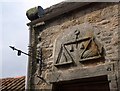
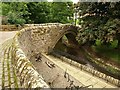
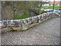
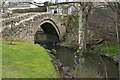
The Spout Well is located just across the iron footbridge over Ceres Burn.
You may be viewing yesterday's version of this page. To see the most up to date information please register for a free account.
Do not use the above information on other web sites or publications without permission of the contributor.
Nearby Images from Geograph Britain and Ireland:
©2008(licence)
©2008(licence)
©2012(licence)
©2011(licence)
©2011(licence)
The above images may not be of the site on this page, they are loaded from Geograph.
Please Submit an Image of this site or go out and take one for us!
Click here to see more info for this site
Nearby sites
Key: Red: member's photo, Blue: 3rd party photo, Yellow: other image, Green: no photo - please go there and take one, Grey: site destroyed
Download sites to:
KML (Google Earth)
GPX (GPS waypoints)
CSV (Garmin/Navman)
CSV (Excel)
To unlock full downloads you need to sign up as a Contributory Member. Otherwise downloads are limited to 50 sites.
Turn off the page maps and other distractions
Nearby sites listing. In the following links * = Image available
4.2km SSE 167° Norrie's Law* Round Barrow(s) (NO409073)
5.3km W 269° Walton Symbol Stone Class I Pictish Symbol Stone (NO34651135)
6.2km ENE 72° Drumcarrow Craig* Broch or Nuraghe (NO459132)
8.3km SSE 163° Largo Pictish Stone* Class II Pictish Symbol Stone (NO42340347)
8.3km SSW 195° Aithernie (Scoonie) Cairn (NO37690339)
8.7km S 176° Lundin Links* Stone Circle (NO40480272)
8.8km SSW 196° Balgrummo* Standing Stone (Menhir) (NO375029)
9.3km NNW 346° Lochmaloney Farmm (Kilmany) Rock Art (NO37902049)
10.8km W 279° Collessie* Standing Stone (Menhir) (NO293132)
10.9km W 279° Newton of Collessie Class I Pictish Symbol Stone (NO292132)
11.0km ENE 64° St. Andrews Museum* Museum (NO5016)
11.2km N 358° Kilmany Cursus Cursus (NO39742263)
11.4km NNE 27° St Bunyan's Well (Leuchars) Holy Well or Sacred Spring (NO4525221483)
11.6km NNE 28° Lady's Well (Leuchars) Holy Well or Sacred Spring (NO4557321645)
11.8km ENE 62° The Blue Stane (St Andrews)* Standing Stone (Menhir) (NO5055216707)
12.2km SE 127° Easter Pitcorthie* Standing Stone (Menhir) (NO497039)
12.5km ENE 65° Monk's Well, St Andrews* Holy Well or Sacred Spring (NO514166)
12.5km NW 319° Creich Manse* Class I Pictish Symbol Stone (NO319210)
13.0km E 91° Dunino Stone Circle (NO530110)
13.9km NNW 342° Monk's Well (Balmerino)* Holy Well or Sacred Spring (NO358247)
14.0km E 91° Dunino Den* Stone Row / Alignment (NO540109)
14.0km E 92° Druid's Well (Dunino)* Holy Well or Sacred Spring (NO540108)
14.1km SW 233° Balfarg Riding School mortuary enclosure and henge* Henge (NO28480314)
14.2km SW 233° Balbirnie* Stone Circle (NO2858702969)
14.4km SW 234° Balfarg Henge* Henge (NO2819803123)
View more nearby sites and additional images


 We would like to know more about this location. Please feel free to add a brief description and any relevant information in your own language.
 Wir möchten mehr über diese Stätte erfahren. Bitte zögern Sie nicht, eine kurze Beschreibung und relevante Informationen in Deutsch hinzuzufügen.
 Nous aimerions en savoir encore un peu sur les lieux. S'il vous plaît n'hesitez pas à ajouter une courte description et tous les renseignements pertinents dans votre propre langue.
 Quisieramos informarnos un poco más de las lugares. No dude en añadir una breve descripción y otros datos relevantes en su propio idioma.