


<< Text Pages >> Kirkhead Cave - Cave or Rock Shelter in England in Cumbria
Submitted by Anonymous on Friday, 30 April 2021 Page Views: 1002
Natural PlacesSite Name: Kirkhead Cave Alternative Name: Kirkhead CavernCountry: England
NOTE: This site is 2.764 km away from the location you searched for.
County: Cumbria Type: Cave or Rock Shelter
Map Ref: SD391758
Latitude: 54.174357N Longitude: 2.934454W
Condition:
| 5 | Perfect |
| 4 | Almost Perfect |
| 3 | Reasonable but with some damage |
| 2 | Ruined but still recognisable as an ancient site |
| 1 | Pretty much destroyed, possibly visible as crop marks |
| 0 | No data. |
| -1 | Completely destroyed |
| 5 | Superb |
| 4 | Good |
| 3 | Ordinary |
| 2 | Not Good |
| 1 | Awful |
| 0 | No data. |
| 5 | Can be driven to, probably with disabled access |
| 4 | Short walk on a footpath |
| 3 | Requiring a bit more of a walk |
| 2 | A long walk |
| 1 | In the middle of nowhere, a nightmare to find |
| 0 | No data. |
| 5 | co-ordinates taken by GPS or official recorded co-ordinates |
| 4 | co-ordinates scaled from a detailed map |
| 3 | co-ordinates scaled from a bad map |
| 2 | co-ordinates of the nearest village |
| 1 | co-ordinates of the nearest town |
| 0 | no data |
Be the first person to rate this site - see the 'Contribute!' box in the right hand menu.
Internal Links:
External Links:
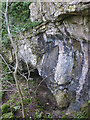
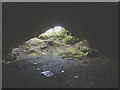
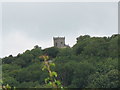
Limestone cavern with upper palaeolithic human finds, one of the earliest such sites in Northern Britain. Horse and elk bones were also found.
You may be viewing yesterday's version of this page. To see the most up to date information please register for a free account.
Do not use the above information on other web sites or publications without permission of the contributor.
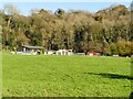
Nearby Images from Geograph Britain and Ireland:
©2023(licence)
©2018(licence)
©2018(licence)
©2016(licence)
©2009(licence)
The above images may not be of the site on this page, they are loaded from Geograph.
Please Submit an Image of this site or go out and take one for us!
Click here to see more info for this site
Nearby sites
Key: Red: member's photo, Blue: 3rd party photo, Yellow: other image, Green: no photo - please go there and take one, Grey: site destroyed
Download sites to:
KML (Google Earth)
GPX (GPS waypoints)
CSV (Garmin/Navman)
CSV (Excel)
To unlock full downloads you need to sign up as a Contributory Member. Otherwise downloads are limited to 50 sites.
Turn off the page maps and other distractions
Nearby sites listing. In the following links * = Image available
1.9km S 182° Holy Well (Humphrey Head)* Holy Well or Sacred Spring (SD39017391)
2.4km S 178° Fairy Stone (Humphrey Head)* Natural Stone / Erratic / Other Natural Feature (SD39157344)
3.6km WNW 296° Holker Labyrinth and Standing Stones Modern Stone Circle etc (SD3590677373)
4.9km NE 37° Castle-Head (Lindale) Promontory Fort / Cliff Castle (SD421797)
5.9km ENE 67° Grubbins Wood Stone Natural Stone / Erratic / Other Natural Feature (SD446780)
7.1km ESE 104° Woodwell* Holy Well or Sacred Spring (SD4674)
8.4km E 83° Bowk Stone Natural Stone / Erratic / Other Natural Feature (SD475767)
8.5km ENE 72° Hazelslack Stone* Standing Stone (Menhir) (SD473783)
8.8km E 81° Haweswater Stones* Misc. Earthwork (SD478770)
8.8km E 82° Haweswater Cairns and Propped Stone Cairn (SD479769)
9.2km ESE 107° Ings Point Natural Stone / Erratic / Other Natural Feature (SD479730)
9.5km ESE 107° Badger Hole (Lancashire)* Cave or Rock Shelter (SD48187285)
9.6km ESE 106° Dog Holes* Cave or Rock Shelter (SD48337303)
9.9km NW 309° Sheriff's Well (Greenodd) Holy Well or Sacred Spring (SD3150082130)
9.9km ESE 112° Cote Stones Cairn (SD482719)
9.9km ENE 63° Haverbrack Cairn Cairn (SD480802)
9.9km ENE 64° Dog Hole possible dolmen/propped stone* Natural Stone / Erratic / Other Natural Feature (SD481801)
10.0km WSW 259° Druids Temple (Cumbria)* Stone Circle (SD29237396)
10.0km ENE 64° The Dog Hole Cave or Rock Shelter (SD482801)
10.2km WNW 288° Hoad Hill* Cairn (SD294790)
10.2km ENE 71° The Fairy Steps* Natural Stone / Erratic / Other Natural Feature (SD488790)
10.3km W 261° Birkrigg Common Round Cairn 2 Round Cairn (SD289743)
10.3km W 262° Birkrigg Common Settlement* Ancient Village or Settlement (SD28837453)
10.3km NW 312° Greenodd Holy Well (Egton with Newland) Holy Well or Sacred Spring (SD3144082770)
10.3km W 263° Birkrigg Common Round Cairn 3 Round Cairn (SD288746)
View more nearby sites and additional images


 We would like to know more about this location. Please feel free to add a brief description and any relevant information in your own language.
 Wir möchten mehr über diese Stätte erfahren. Bitte zögern Sie nicht, eine kurze Beschreibung und relevante Informationen in Deutsch hinzuzufügen.
 Nous aimerions en savoir encore un peu sur les lieux. S'il vous plaît n'hesitez pas à ajouter une courte description et tous les renseignements pertinents dans votre propre langue.
 Quisieramos informarnos un poco más de las lugares. No dude en añadir una breve descripción y otros datos relevantes en su propio idioma.