


<< Our Photo Pages >> Church of Saint Peter and Saint Paul - Carving in England in Lancashire
Submitted by Elthollr on Tuesday, 06 December 2011 Page Views: 8068
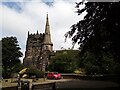
Multi-periodSite Name: Church of Saint Peter and Saint Paul Alternative Name: Ormskirk Parish ChurchCountry: England
NOTE: This site is 11.162 km away from the location you searched for.
County: Lancashire Type: Carving
Nearest Town: Ormskirk
Map Ref: SD4130608436
Latitude: 53.569232N Longitude: 2.887746W
Condition:
| 5 | Perfect |
| 4 | Almost Perfect |
| 3 | Reasonable but with some damage |
| 2 | Ruined but still recognisable as an ancient site |
| 1 | Pretty much destroyed, possibly visible as crop marks |
| 0 | No data. |
| -1 | Completely destroyed |
| 5 | Superb |
| 4 | Good |
| 3 | Ordinary |
| 2 | Not Good |
| 1 | Awful |
| 0 | No data. |
| 5 | Can be driven to, probably with disabled access |
| 4 | Short walk on a footpath |
| 3 | Requiring a bit more of a walk |
| 2 | A long walk |
| 1 | In the middle of nowhere, a nightmare to find |
| 0 | No data. |
| 5 | co-ordinates taken by GPS or official recorded co-ordinates |
| 4 | co-ordinates scaled from a detailed map |
| 3 | co-ordinates scaled from a bad map |
| 2 | co-ordinates of the nearest village |
| 1 | co-ordinates of the nearest town |
| 0 | no data |
Internal Links:
External Links:
")
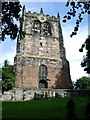
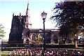
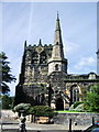
Possible Anglo-Scandinavian carving located in the masonry of the church's east wall. The carving depicts a man and a woman. It appears that the stone slab on which the image is carved has been taken from another site, perhaps the earlier Anglo-Scandinavian church as it seems to have been carved in a portrait orientation but is now on its side in line with the other bricks in the wall. According to the church's website, the earliest part of the building is the Norman window in the chancel which dates to c. 1170. Little has been written on the church's early medieval history as Ormskirk does not appear in the Domesday survey of 1086 but due to the Old Norse place name it is likely the current church stands on the site of a much earlier building, possibly tenth century around the time of the Scandinavian settlement of the north-west. To the left of the carving is another carving depicting a bird which is clearly much later as it is carved into one of the sandstone bricks that make up the east wall.
You may be viewing yesterday's version of this page. To see the most up to date information please register for a free account.
")
Do not use the above information on other web sites or publications without permission of the contributor.
Nearby Images from Geograph Britain and Ireland:
©2007(licence)
©2020(licence)
©2014(licence)
©2007(licence)
©2021(licence)
The above images may not be of the site on this page, they are loaded from Geograph.
Please Submit an Image of this site or go out and take one for us!
Click here to see more info for this site
Nearby sites
Key: Red: member's photo, Blue: 3rd party photo, Yellow: other image, Green: no photo - please go there and take one, Grey: site destroyed
Download sites to:
KML (Google Earth)
GPX (GPS waypoints)
CSV (Garmin/Navman)
CSV (Excel)
To unlock full downloads you need to sign up as a Contributory Member. Otherwise downloads are limited to 50 sites.
Turn off the page maps and other distractions
Nearby sites listing. In the following links * = Image available
8.6km SW 227° Lunt Meadows* Ancient Village or Settlement (SD349027)
9.2km SW 219° St Helen's Well (Sefton) Holy Well or Sacred Spring (SD35450129)
10.8km ENE 75° Boar's Den* Round Barrow(s) (SD51771116)
12.1km NE 49° Robin Hood Well (Mawdesley)* Holy Well or Sacred Spring (SD50571628)
13.3km W 262° The Godstone* Marker Stone (SD28070668)
13.8km W 267° Formby Point* Ancient Trackway (SD27500800)
14.6km SSW 201° St Mary (Walton on the Hill) Ancient Cross (SJ35889482)
14.7km E 83° Standish Well Holy Well or Sacred Spring (SD560100)
14.8km SSW 197° Modern stone circle on Cherry Avenue* Modern Stone Circle etc (SJ3687894265)
15.4km ENE 76° Hic-bibi Well* Holy Well or Sacred Spring (SD56331208)
17.3km E 96° Mabs Cross* Ancient Cross (SD5852706268)
18.3km NE 43° Leyland Town Cross Ancient Cross (SD5400221602)
18.8km SSW 199° World Museum Liverpool* Museum (SJ348908)
18.8km ENE 58° Astley Hall Farm Bronze Age Burial Round Barrow(s) (SD574183)
18.9km S 185° Monk's Well (Wavertree)* Holy Well or Sacred Spring (SJ39288959)
19.1km SSE 152° St Anne's Well (St Helens)* Holy Well or Sacred Spring (SJ49969143)
19.4km SE 132° Windmill Hill (Earlestown)* Round Barrow(s) (SJ55639531)
20.8km ESE 120° Lady Hill* Round Barrow(s) (SJ5916497670)
20.8km S 182° The Calderstones* Chambered Tomb (SJ4040287622)
21.0km ENE 77° Grimeford Headless Cross* Ancient Cross (SD6190113018)
21.4km NNE 26° Howick Cross* Ancient Cross (SD5081927574)
21.5km ENE 75° Rivington Stone* Rock Art (SD62181378)
22.0km ESE 123° Castle Hill (Newton Le Willows)* Round Barrow(s) (SJ59609617)
22.0km S 185° Solomon's Tomb Modern Stone Circle etc (SJ391865)
22.1km S 183° Robin Hood's Stone* Standing Stone (Menhir) (SJ3997886383)
View more nearby sites and additional images


 We would like to know more about this location. Please feel free to add a brief description and any relevant information in your own language.
 Wir möchten mehr über diese Stätte erfahren. Bitte zögern Sie nicht, eine kurze Beschreibung und relevante Informationen in Deutsch hinzuzufügen.
 Nous aimerions en savoir encore un peu sur les lieux. S'il vous plaît n'hesitez pas à ajouter une courte description et tous les renseignements pertinents dans votre propre langue.
 Quisieramos informarnos un poco más de las lugares. No dude en añadir una breve descripción y otros datos relevantes en su propio idioma.