

<< Our Photo Pages >> Rolstone - Standing Stone (Menhir) in England in Somerset
Submitted by richbaber on Friday, 27 March 2015 Page Views: 3496
Neolithic and Bronze AgeSite Name: RolstoneCountry: England County: Somerset Type: Standing Stone (Menhir)
Nearest Town: Weston-super-Mare Nearest Village: Banwell
Map Ref: ST38736120
Latitude: 51.346563N Longitude: 2.881108W
Condition:
| 5 | Perfect |
| 4 | Almost Perfect |
| 3 | Reasonable but with some damage |
| 2 | Ruined but still recognisable as an ancient site |
| 1 | Pretty much destroyed, possibly visible as crop marks |
| 0 | No data. |
| -1 | Completely destroyed |
| 5 | Superb |
| 4 | Good |
| 3 | Ordinary |
| 2 | Not Good |
| 1 | Awful |
| 0 | No data. |
| 5 | Can be driven to, probably with disabled access |
| 4 | Short walk on a footpath |
| 3 | Requiring a bit more of a walk |
| 2 | A long walk |
| 1 | In the middle of nowhere, a nightmare to find |
| 0 | No data. |
| 5 | co-ordinates taken by GPS or official recorded co-ordinates |
| 4 | co-ordinates scaled from a detailed map |
| 3 | co-ordinates scaled from a bad map |
| 2 | co-ordinates of the nearest village |
| 1 | co-ordinates of the nearest town |
| 0 | no data |
Internal Links:
External Links:
I have visited· I would like to visit
ermine would like to visit
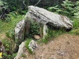
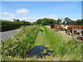
philw visited on 1st Aug 2020 - their rating: Cond: 3 Amb: 3 Access: 4 Just a single stone, access is via hopping over a gate into the field. I cycled here as it's not far from where I live, but theres a few wider parts of the road you could probably park in.
Lots of quartz in the stone.
TheCaptain have visited here
")
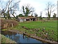
Access is over a small bridge over a rhyne, where it is possible to park. A farm gate then provides access to the field where the stone is clearly visible.
My local research has drawn a blank as to the stone's origin. There are standing stones a few kilometres away at Compton Bishop and Yarberry. Hill forts abound in the North Somerset area. I am convinced that this is a stone from the same period. Images to follow.
You may be viewing yesterday's version of this page. To see the most up to date information please register for a free account.
")
")
")
Do not use the above information on other web sites or publications without permission of the contributor.
Nearby Images from Geograph Britain and Ireland:
©2019(licence)
©2021(licence)
©2019(licence)
©2019(licence)
©2018(licence)
The above images may not be of the site on this page, they are loaded from Geograph.
Please Submit an Image of this site or go out and take one for us!
Click here to see more info for this site
Nearby sites
Key: Red: member's photo, Blue: 3rd party photo, Yellow: other image, Green: no photo - please go there and take one, Grey: site destroyed
Download sites to:
KML (Google Earth)
GPX (GPS waypoints)
CSV (Garmin/Navman)
CSV (Excel)
To unlock full downloads you need to sign up as a Contributory Member. Otherwise downloads are limited to 50 sites.
Turn off the page maps and other distractions
Nearby sites listing. In the following links * = Image available
3.1km SE 135° Banwell Camp Hillfort (ST409590)
3.4km S 174° Wook's Quoit* Standing Stone (Menhir) (ST39045783)
3.7km SSW 193° Flagstaff Hill* Stone Circle (ST3785257630)
4.7km SSW 207° Loxton Hill Barrows Round Barrow(s) (ST36565704)
4.7km NNW 332° Wick St Lawrence Village Cross* Ancient Cross (ST3660565388)
5.3km ESE 120° The Wimblestone* Standing Stone (Menhir) (ST43355848)
5.5km ENE 62° Congresbury Church Cross* Ancient Cross (ST4359863744)
5.5km S 191° Loxton Churchyard Cross* Ancient Cross (ST3762455813)
5.6km ENE 62° Congresbury Village Cross* Ancient Cross (ST4373263818)
5.7km SSE 159° Wavering Down cairn* Round Cairn (ST40705590)
5.8km NNE 13° Kingston Seymour Churchyard Cross* Ancient Cross (ST4010166846)
5.9km S 171° Compton Bishop Church Cross* Ancient Cross (ST3959955378)
5.9km NNE 14° Kingston Seymour Village Cross* Ancient Cross (ST4022366941)
6.1km NE 46° Yatton Churchyard Cross* Ancient Cross (ST4312665395)
6.3km SW 226° Bleadon Cross* Ancient Cross (ST3411056921)
6.5km W 272° North Somerset Museum Museum (ST322615)
6.6km W 273° Weston-super-Mare Museum* Museum (ST3217061568)
6.6km NE 55° Cadbury Hill* Hillfort (ST442649)
6.7km ESE 110° Dolebury Camp* Hillfort (ST450589)
6.8km SSE 161° Compton Bishop* Standing Stones (ST409548)
6.8km ESE 114° Barrow at Rowberrow* Round Barrow(s) (ST44925834)
6.9km NW 323° Middle Hope Round Barrow(s) (ST34656676)
7.0km NW 322° Woodspring Priory Field System Misc. Earthwork (ST345668)
7.3km W 280° Worlebury Camp* Hillfort (ST315625)
7.8km S 183° Biddisham Churchyard Cross* Ancient Cross (ST3819353429)
View more nearby sites and additional images


 We would like to know more about this location. Please feel free to add a brief description and any relevant information in your own language.
 Wir möchten mehr über diese Stätte erfahren. Bitte zögern Sie nicht, eine kurze Beschreibung und relevante Informationen in Deutsch hinzuzufügen.
 Nous aimerions en savoir encore un peu sur les lieux. S'il vous plaît n'hesitez pas à ajouter une courte description et tous les renseignements pertinents dans votre propre langue.
 Quisieramos informarnos un poco más de las lugares. No dude en añadir una breve descripción y otros datos relevantes en su propio idioma.