 with our Megalithic Portal iPhone app")


<< Our Photo Pages >> Norton Stones - Misc. Earthwork in England in Worcestershire
Submitted by rogerkread on Friday, 06 October 2023 Page Views: 136
Multi-periodSite Name: Norton StonesCountry: England
NOTE: This site is 1.363 km away from the location you searched for.
County: Worcestershire Type: Misc. Earthwork
Nearest Town: Tewkesbury Nearest Village: Bredon's Norton
Map Ref: SO386940
Latitude: 52.540379N Longitude: 2.90674W
Condition:
| 5 | Perfect |
| 4 | Almost Perfect |
| 3 | Reasonable but with some damage |
| 2 | Ruined but still recognisable as an ancient site |
| 1 | Pretty much destroyed, possibly visible as crop marks |
| 0 | No data. |
| -1 | Completely destroyed |
| 5 | Superb |
| 4 | Good |
| 3 | Ordinary |
| 2 | Not Good |
| 1 | Awful |
| 0 | No data. |
| 5 | Can be driven to, probably with disabled access |
| 4 | Short walk on a footpath |
| 3 | Requiring a bit more of a walk |
| 2 | A long walk |
| 1 | In the middle of nowhere, a nightmare to find |
| 0 | No data. |
| 5 | co-ordinates taken by GPS or official recorded co-ordinates |
| 4 | co-ordinates scaled from a detailed map |
| 3 | co-ordinates scaled from a bad map |
| 2 | co-ordinates of the nearest village |
| 1 | co-ordinates of the nearest town |
| 0 | no data |
Internal Links:
External Links:
")
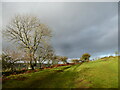
A group of stones beside a public footpath at the top of a field below Aldwick Wood, Bredon. They are not an outcrop; they are earthfast; they lie apparently scattered not heaped so unlikely to be field clearance; the pattern of them in the field does not suggest either that they have been placed deliberately nor that they are the remains of a building of other structure . The lack of any other stones in the neighbourhood makes it unlikely that they have merely rolled down the hill. So something of an enigma. There is apparently some feeling locally that they may be of archaeological significance which is why I decided to upload the photos.
You may be viewing yesterday's version of this page. To see the most up to date information please register for a free account.
")
")
")
Do not use the above information on other web sites or publications without permission of the contributor.
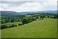
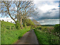
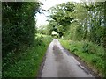
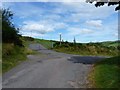
Nearby Images from Geograph Britain and Ireland:
©2016(licence)
©2018(licence)
©2012(licence)
©2012(licence)
©2020(licence)
The above images may not be of the site on this page, they are loaded from Geograph.
Please Submit an Image of this site or go out and take one for us!
Click here to see more info for this site
Nearby sites
Key: Red: member's photo, Blue: 3rd party photo, Yellow: other image, Green: no photo - please go there and take one, Grey: site destroyed
Download sites to:
KML (Google Earth)
GPX (GPS waypoints)
CSV (Garmin/Navman)
CSV (Excel)
To unlock full downloads you need to sign up as a Contributory Member. Otherwise downloads are limited to 50 sites.
Turn off the page maps and other distractions
Nearby sites listing. In the following links * = Image available
1.4km ESE 123° Robury Ring* Misc. Earthwork (SO39799321)
2.5km E 92° Pole Cottage* Round Barrow(s) (SO411939)
2.8km WNW 300° Linley Hill Camp* Misc. Earthwork (SO362954)
3.0km ESE 103° Long Mynd B* Round Barrow(s) (SO41539330)
3.7km E 80° Boiling Well (Long Mynd)* Round Barrow(s) (SO423946)
3.8km ENE 67° Shooting Box Disc Barrow* Round Barrow(s) (SO421954)
3.9km NNE 32° Ratlinghope Hill Camp* Hillfort (SO407973)
4.0km ENE 67° Long Mynd C* Round Barrow(s) (SO423955)
4.0km E 82° Long Mynd A* Round Barrow(s) (SO426945)
4.2km ESE 107° Barrister's Plain Cross Dyke* Ancient Village or Settlement (SO426927)
4.2km NNE 26° Castle Ring (Stitt Hill)* Hillfort (SO405978)
4.5km ESE 110° Cross Dyke Bowl Barrow South* Round Barrow(s) (SO42869241)
4.6km ESE 109° Cross Dyke Bowl Barrow North* Round Barrow(s) (SO42899244)
4.7km NE 54° Wildmoor Bowl Barrow* Round Barrow(s) (SO42409672)
4.9km NNE 31° Ratlinghope Hill Bowl Barrow* Round Barrow(s) (SO41179817)
4.9km SSE 153° Botley Stone* Ring Cairn (SO408896)
5.1km NE 55° Henley Knap Bowl Barrow* Round Barrow(s) (SO42799685)
5.1km ENE 59° Robin Hood's Butts (Shropshire)* Round Barrow(s) (SO43029655)
5.1km NNW 339° The Stiperstones* Cairn (SO36799880)
5.2km W 274° Heath Mynd Bronze Age Homestead* Misc. Earthwork (SO33369447)
5.3km E 87° The Devil's Mouth Cross Dyke* Misc. Earthwork (SO43959425)
5.4km E 98° Ashlet Hill Bowl Barrow Round Barrow(s) (SO440932)
5.5km NW 311° Ritton Castle* Hillfort (SO34449765)
5.9km E 82° Bodbury Ring* Hillfort (SO445947)
6.1km NNE 20° Leasowes Barrow* Round Barrow(s) (SO408997)
View more nearby sites and additional images


 We would like to know more about this location. Please feel free to add a brief description and any relevant information in your own language.
 Wir möchten mehr über diese Stätte erfahren. Bitte zögern Sie nicht, eine kurze Beschreibung und relevante Informationen in Deutsch hinzuzufügen.
 Nous aimerions en savoir encore un peu sur les lieux. S'il vous plaît n'hesitez pas à ajouter une courte description et tous les renseignements pertinents dans votre propre langue.
 Quisieramos informarnos un poco más de las lugares. No dude en añadir una breve descripción y otros datos relevantes en su propio idioma.