 with our Megalithic Portal iPhone app")


<< Our Photo Pages >> Wart Hill Camp - Hillfort in England in Shropshire
Submitted by TheWhiteRider on Sunday, 04 June 2006 Page Views: 9068
Iron Age and Later PrehistorySite Name: Wart Hill Camp Alternative Name: Wart Hill HillfortCountry: England County: Shropshire Type: Hillfort
Nearest Town: Craven Arms Nearest Village: Hopesay
Map Ref: SO400847
Latitude: 52.456939N Longitude: 2.884421W
Condition:
| 5 | Perfect |
| 4 | Almost Perfect |
| 3 | Reasonable but with some damage |
| 2 | Ruined but still recognisable as an ancient site |
| 1 | Pretty much destroyed, possibly visible as crop marks |
| 0 | No data. |
| -1 | Completely destroyed |
| 5 | Superb |
| 4 | Good |
| 3 | Ordinary |
| 2 | Not Good |
| 1 | Awful |
| 0 | No data. |
| 5 | Can be driven to, probably with disabled access |
| 4 | Short walk on a footpath |
| 3 | Requiring a bit more of a walk |
| 2 | A long walk |
| 1 | In the middle of nowhere, a nightmare to find |
| 0 | No data. |
| 5 | co-ordinates taken by GPS or official recorded co-ordinates |
| 4 | co-ordinates scaled from a detailed map |
| 3 | co-ordinates scaled from a bad map |
| 2 | co-ordinates of the nearest village |
| 1 | co-ordinates of the nearest town |
| 0 | no data |
Internal Links:
External Links:
I have visited· I would like to visit
TheWhiteRider has visited here
")
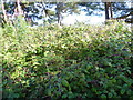
A small hiilfort or settlement on Wart Hill, now largely destroyed by forestry activity in the C20th.
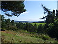
The summit of Wart Hill, reached by a short, but sharp climb, offers rewarding views of the Shropshire Hills. However the location of the Iron Age remains is quite difficult to ascertain as what is left of the site, after heavy duty landscaping for a larch plantation in the 1930s, is reduced to scarp banks at the southern end of the feature.
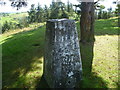
The summit is a really nice spot, the footpath running through a small grassy area with the trig point and a few larch trees. To the edge of the grassy area are the scarp banks. The climb to the summit is signposted just off the Shropshire Way as part of a collection of walks established by The Secret Hills Discovery Centre in Craven Arms.
You may be viewing yesterday's version of this page. To see the most up to date information please register for a free account.
")
")
")
")
Do not use the above information on other web sites or publications without permission of the contributor.
Nearby Images from Geograph Britain and Ireland:

©2015(licence)
©2015(licence)
©2015(licence)
©2015(licence)
©2015(licence)
The above images may not be of the site on this page, they are loaded from Geograph.
Please Submit an Image of this site or go out and take one for us!
Click here to see more info for this site
Nearby sites
Key: Red: member's photo, Blue: 3rd party photo, Yellow: other image, Green: no photo - please go there and take one, Grey: site destroyed
Download sites to:
KML (Google Earth)
GPX (GPS waypoints)
CSV (Garmin/Navman)
CSV (Excel)
To unlock full downloads you need to sign up as a Contributory Member. Otherwise downloads are limited to 50 sites.
Turn off the page maps and other distractions
Nearby sites listing. In the following links * = Image available
2.2km N 2° Castle Ring (Shropshire)* Misc. Earthwork (SO40128689)
2.4km SW 227° Burrow Hill Camp (Shropshire)* Hillfort (SO38218305)
3.1km ESE 102° Belair Bowl Barrow* Round Barrow(s) (SO430840)
3.6km SE 125° Tumpy Hill Round Barrow(s) (SO429826)
4.1km ESE 122° Secret Hills Discovery Centre* Museum (SO435825)
4.3km ENE 75° Strefford Henge Henge (SO442858)
5.0km N 9° Botley Stone* Ring Cairn (SO408896)
5.5km ESE 120° Norton Camp (Shropshire)* Hillfort (SO44728193)
5.8km SSW 208° Fairy Stone* Natural Stone / Erratic / Other Natural Feature (SO37237958)
6.9km SSW 212° Hopton Castle Standing Stone (Menhir) (SO36297883)
7.3km W 261° Bury Ditches (Shropshire)* Hillfort (SO327837)
8.2km NNE 20° Cross Dyke Bowl Barrow South* Round Barrow(s) (SO42869241)
8.3km NNE 20° Cross Dyke Bowl Barrow North* Round Barrow(s) (SO42899244)
8.4km NNE 17° Barrister's Plain Cross Dyke* Ancient Village or Settlement (SO426927)
8.5km N 358° Robury Ring* Misc. Earthwork (SO39799321)
8.5km WSW 249° Radnor Wood Camp* Hillfort (SO320817)
8.7km N 9° Long Mynd B* Round Barrow(s) (SO41539330)
9.3km N 6° Pole Cottage* Round Barrow(s) (SO411939)
9.4km S 182° Leintwardine Cursus Cursus (SO39577534)
9.4km NNE 24° Ashlet Hill Bowl Barrow Round Barrow(s) (SO440932)
9.4km N 351° Norton Stones* Misc. Earthwork (SO386940)
9.8km SW 215° Great Hagley* Standing Stone (Menhir) (SO343767)
9.9km SSW 207° Castle Ditches (Shropshire)* Ancient Village or Settlement (SO35357594)
10.0km SW 232° Fiddler's Elbow Standing Stone (Menhir) (SO32007865)
10.1km NNE 14° Long Mynd A* Round Barrow(s) (SO426945)
View more nearby sites and additional images


 We would like to know more about this location. Please feel free to add a brief description and any relevant information in your own language.
 Wir möchten mehr über diese Stätte erfahren. Bitte zögern Sie nicht, eine kurze Beschreibung und relevante Informationen in Deutsch hinzuzufügen.
 Nous aimerions en savoir encore un peu sur les lieux. S'il vous plaît n'hesitez pas à ajouter une courte description et tous les renseignements pertinents dans votre propre langue.
 Quisieramos informarnos un poco más de las lugares. No dude en añadir una breve descripción y otros datos relevantes en su propio idioma.