


<< Our Photo Pages >> Pople's Well - Holy Well or Sacred Spring in England in Somerset
Submitted by lamaick on Wednesday, 11 March 2015 Page Views: 3740
Springs and Holy WellsSite Name: Pople's WellCountry: England County: Somerset Type: Holy Well or Sacred Spring
Nearest Town: Crewkerne
Map Ref: ST4387909886
Latitude: 50.885723N Longitude: 2.799185W
Condition:
| 5 | Perfect |
| 4 | Almost Perfect |
| 3 | Reasonable but with some damage |
| 2 | Ruined but still recognisable as an ancient site |
| 1 | Pretty much destroyed, possibly visible as crop marks |
| 0 | No data. |
| -1 | Completely destroyed |
| 5 | Superb |
| 4 | Good |
| 3 | Ordinary |
| 2 | Not Good |
| 1 | Awful |
| 0 | No data. |
| 5 | Can be driven to, probably with disabled access |
| 4 | Short walk on a footpath |
| 3 | Requiring a bit more of a walk |
| 2 | A long walk |
| 1 | In the middle of nowhere, a nightmare to find |
| 0 | No data. |
| 5 | co-ordinates taken by GPS or official recorded co-ordinates |
| 4 | co-ordinates scaled from a detailed map |
| 3 | co-ordinates scaled from a bad map |
| 2 | co-ordinates of the nearest village |
| 1 | co-ordinates of the nearest town |
| 0 | no data |
Internal Links:
External Links:
")
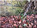
The well is located in Crewkerne, Somerset literally along 'Pople's Well' Road. It has steps leading down to the spring.
You may be viewing yesterday's version of this page. To see the most up to date information please register for a free account.
")
Do not use the above information on other web sites or publications without permission of the contributor.
davidmorgan has found this location on Google Street View:
Nearby Images from Geograph Britain and Ireland:
©2008(licence)
©2016(licence)
©2018(licence)
©2017(licence)
©2008(licence)
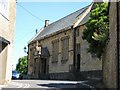
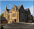
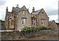
The above images may not be of the site on this page, they are loaded from Geograph.
Please Submit an Image of this site or go out and take one for us!
Click here to see more info for this site
Nearby sites
Key: Red: member's photo, Blue: 3rd party photo, Yellow: other image, Green: no photo - please go there and take one, Grey: site destroyed
Download sites to:
KML (Google Earth)
GPX (GPS waypoints)
CSV (Garmin/Navman)
CSV (Excel)
To unlock full downloads you need to sign up as a Contributory Member. Otherwise downloads are limited to 50 sites.
Turn off the page maps and other distractions
Nearby sites listing. In the following links * = Image available
5.7km SE 145° Pickett Farm Neolithic Site Misc. Earthwork (ST47100519)
7.1km S 184° St Dunstan's Well* Holy Well or Sacred Spring (ST433028)
8.0km NNE 30° Ham Hill (Somerset)* Hillfort (ST480168)
8.2km NNE 28° Ham Hill stone circle* Modern Stone Circle etc (ST478171)
8.6km SE 127° Higher Ground Meadow Modern Burial Mound* Artificial Mound (ST5066904650)
8.7km S 181° Lewesdon Hillfort Hillfort (ST437012)
9.0km SSW 196° Pilsdon Pen* Hillfort (ST413013)
9.1km ESE 124° Corscombe* Standing Stones (ST514048)
9.7km ENE 69° Holy Well (West Coker)* Holy Well or Sacred Spring (ST52951325)
10.0km SSW 200° Bettiscombe Stone Natural Stone / Erratic / Other Natural Feature (ST4036800561)
10.2km SE 129° Hore Stones* Standing Stones (ST5178603403)
12.7km E 89° Closworth Cursus Cursus (ST56581008)
12.7km SSW 211° Lambert's Castle* Hillfort (SY372991)
14.1km SSW 208° Coney's Castle* Hillfort (SY372975)
14.1km NW 309° Skipperhams Well* Holy Well or Sacred Spring (ST329188)
14.3km ESE 111° St John's Well (Evershot)* Holy Well or Sacred Spring (ST5721304596)
14.5km W 279° Combe Beacon Tumulus* Long Barrow (ST295122)
14.6km ESE 110° Evershot Stones* Standing Stones (ST57600469)
15.0km SE 128° Wraxall Cromlech Burial Chamber or Dolmen (ST557006)
15.0km SSW 196° St Candida & Holy Cross (Whitchurch Canonicorum)* Early Christian Sculptured Stone (SY3967895432)
15.1km NNE 32° Ilchester Museum Museum (ST521226)
15.4km NNW 329° St. Catherine's Well (Swell)* Holy Well or Sacred Spring (ST360231)
15.5km E 87° St Andrew (Yetminster) Ancient Cross (ST59421066)
15.8km W 275° Northay Barrow* Long Barrow (ST281115)
16.6km SSW 193° St Candida's Well* Holy Well or Sacred Spring (SY3995193753)
View more nearby sites and additional images


 We would like to know more about this location. Please feel free to add a brief description and any relevant information in your own language.
 Wir möchten mehr über diese Stätte erfahren. Bitte zögern Sie nicht, eine kurze Beschreibung und relevante Informationen in Deutsch hinzuzufügen.
 Nous aimerions en savoir encore un peu sur les lieux. S'il vous plaît n'hesitez pas à ajouter une courte description et tous les renseignements pertinents dans votre propre langue.
 Quisieramos informarnos un poco más de las lugares. No dude en añadir una breve descripción y otros datos relevantes en su propio idioma.