


<< Our Photo Pages >> Medieval Grave Covers (Churchtown) - Sculptured Stone in England in Lancashire
Submitted by cactus_chris on Friday, 11 November 2022 Page Views: 368
Multi-periodSite Name: Medieval Grave Covers (Churchtown)Country: England
NOTE: This site is 5.814 km away from the location you searched for.
County: Lancashire Type: Sculptured Stone
Nearest Town: Garstang Nearest Village: Catterall
Map Ref: SD4818242808
Latitude: 53.878866N Longitude: 2.789699W
Condition:
| 5 | Perfect |
| 4 | Almost Perfect |
| 3 | Reasonable but with some damage |
| 2 | Ruined but still recognisable as an ancient site |
| 1 | Pretty much destroyed, possibly visible as crop marks |
| 0 | No data. |
| -1 | Completely destroyed |
| 5 | Superb |
| 4 | Good |
| 3 | Ordinary |
| 2 | Not Good |
| 1 | Awful |
| 0 | No data. |
| 5 | Can be driven to, probably with disabled access |
| 4 | Short walk on a footpath |
| 3 | Requiring a bit more of a walk |
| 2 | A long walk |
| 1 | In the middle of nowhere, a nightmare to find |
| 0 | No data. |
| 5 | co-ordinates taken by GPS or official recorded co-ordinates |
| 4 | co-ordinates scaled from a detailed map |
| 3 | co-ordinates scaled from a bad map |
| 2 | co-ordinates of the nearest village |
| 1 | co-ordinates of the nearest town |
| 0 | no data |
Internal Links:
External Links:
I have visited· I would like to visit
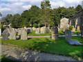
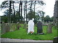
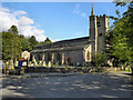
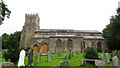
cactus_chris visited on 11th Aug 2022 - their rating: Cond: 4 Amb: 5 Access: 4 These are located around the back of the church.
 (PID:251350)")
https://lancashirepast.com/2017/07/01/st-helens-church-churchtown-near-garstang/
Two medieval grave covers, propped up against the rear wall of the church.
You may be viewing yesterday's version of this page. To see the most up to date information please register for a free account.
 (PID:251351)")
Do not use the above information on other web sites or publications without permission of the contributor.
Nearby Images from Geograph Britain and Ireland:
©2011(licence)
©2008(licence)
©2011(licence)
©2008(licence)
©2021(licence)
The above images may not be of the site on this page, they are loaded from Geograph.
Please Submit an Image of this site or go out and take one for us!
Click here to see more info for this site
Nearby sites
Key: Red: member's photo, Blue: 3rd party photo, Yellow: other image, Green: no photo - please go there and take one, Grey: site destroyed
Download sites to:
KML (Google Earth)
GPX (GPS waypoints)
CSV (Garmin/Navman)
CSV (Excel)
To unlock full downloads you need to sign up as a Contributory Member. Otherwise downloads are limited to 50 sites.
Turn off the page maps and other distractions
Nearby sites listing. In the following links * = Image available
1.0km E 95° Catterall Cross* Ancient Cross (SD4920242700)
3.1km E 96° Claughton Hlaew* Round Barrow(s) (SD51274247)
4.0km NNE 12° Roman Milestone (Garstang)* Marker Stone (SD4907146676)
7.4km ESE 118° St Anne's Well (Inglewhite)* Holy Well or Sacred Spring (SD547392)
7.6km SE 135° Barton Cross Ancient Cross (SD5350037332)
10.0km ENE 71° Bleasdale* Timber Circle (SD5771145994)
11.6km ENE 78° Parlick Pike Cairn* Cairn (SD59574502)
11.8km SE 140° Our Lady's Well, Fernyhalgh* Holy Well or Sacred Spring (SD55613362)
12.4km WNW 292° Fairy Well (Preesall) Holy Well or Sacred Spring (SD3671147562)
13.3km WNW 293° Hakon's Mound (Preesall) Cairn (SD3601048224)
14.0km WSW 243° Bull Spring (Staining) Holy Well or Sacred Spring (SD3556936707)
14.4km SSE 162° Penwortham Castle Hillfort (SD5243429062)
14.4km WSW 246° Fairy Well (Staining) Holy Well or Sacred Spring (SD3490837119)
14.7km SSE 156° Minspit Well (Preston) Holy Well or Sacred Spring (SD540293)
14.8km SSE 163° St Mary's Well (Penwortham) Holy Well or Sacred Spring (SD5232328579)
15.2km ESE 108° The Written Stone* Sculptured Stone (SD6262237892)
15.5km S 170° Howick Cross* Ancient Cross (SD5081927574)
16.3km E 98° Jeffrey Hill Cairn Circle* Cairn (SD644404)
16.5km E 98° Thornley Hall Fell Cairn* Round Barrow(s) (SD64524047)
16.6km SE 130° Marsden Well/Spring* Holy Well or Sacred Spring (SD607319)
17.7km ENE 76° Fairy Holes* Cave or Rock Shelter (SD65534678)
18.4km N 1° Golgotha Lodge (Williamson Park) Cairn (SD48666121)
18.4km ESE 114° St Wilfrid's Church (Ribchester)* Ancient Cross (SD649350)
18.5km ESE 111° St Saviour's Churchyard (Stydd) Ancient Cross (SD6539435971)
18.9km N 358° Lancaster City Museum* Museum (SD4761161729)
View more nearby sites and additional images


 We would like to know more about this location. Please feel free to add a brief description and any relevant information in your own language.
 Wir möchten mehr über diese Stätte erfahren. Bitte zögern Sie nicht, eine kurze Beschreibung und relevante Informationen in Deutsch hinzuzufügen.
 Nous aimerions en savoir encore un peu sur les lieux. S'il vous plaît n'hesitez pas à ajouter une courte description et tous les renseignements pertinents dans votre propre langue.
 Quisieramos informarnos un poco más de las lugares. No dude en añadir una breve descripción y otros datos relevantes en su propio idioma.