


<< Our Photo Pages >> Holy Well (Blakemere) - Holy Well or Sacred Spring in England in Herefordshire
Submitted by Sunny100 on Tuesday, 24 July 2012 Page Views: 3159
Springs and Holy WellsSite Name: Holy Well (Blakemere) Alternative Name: Blakemere holy wellCountry: England
NOTE: This site is 2.161 km away from the location you searched for.
County: Herefordshire Type: Holy Well or Sacred Spring
Nearest Town: Hay-on-Wye Nearest Village: Blakemere
Map Ref: SO37254128
Latitude: 52.066321N Longitude: 2.916798W
Condition:
| 5 | Perfect |
| 4 | Almost Perfect |
| 3 | Reasonable but with some damage |
| 2 | Ruined but still recognisable as an ancient site |
| 1 | Pretty much destroyed, possibly visible as crop marks |
| 0 | No data. |
| -1 | Completely destroyed |
| 5 | Superb |
| 4 | Good |
| 3 | Ordinary |
| 2 | Not Good |
| 1 | Awful |
| 0 | No data. |
| 5 | Can be driven to, probably with disabled access |
| 4 | Short walk on a footpath |
| 3 | Requiring a bit more of a walk |
| 2 | A long walk |
| 1 | In the middle of nowhere, a nightmare to find |
| 0 | No data. |
| 5 | co-ordinates taken by GPS or official recorded co-ordinates |
| 4 | co-ordinates scaled from a detailed map |
| 3 | co-ordinates scaled from a bad map |
| 2 | co-ordinates of the nearest village |
| 1 | co-ordinates of the nearest town |
| 0 | no data |
Internal Links:
External Links:
I have visited· I would like to visit
AJHL visited on 1st Jan 2023 - their rating: Cond: 3 Amb: 2 Access: 5 The site is on private land, essentially in someone’s front garden. You can see it over the fence but cannot get right up to it due to the setting.
geoffstickland have visited here
 (PID:185449)")
At the hamlet of Holywell three-quarters of a mile east of Blakemere. Close by Holywell Farm (on private land) a small pool of water fed by a naturally-formed spring is all that now remains of a once sacred site. The hamlet takes its name from the holy well.
Long ago part of an ancient cross stood by the well. This had Celtic-style interlacing in the form of long loops that formed a cross. The artefact was excavated from the field nearby, but its whereabouts are unknown. We know that the holy well/spring was venerated by the faithful from early Christian times, though, in fact, it is a natural underground spring and therefore predates Christianity from a geological point of view.
You may be viewing yesterday's version of this page. To see the most up to date information please register for a free account.
Do not use the above information on other web sites or publications without permission of the contributor.
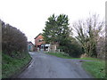
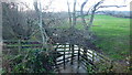
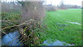
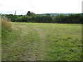
Nearby Images from Geograph Britain and Ireland:
©2007(licence)
©2015(licence)
©2015(licence)
©2010(licence)
©2022(licence)
The above images may not be of the site on this page, they are loaded from Geograph.
Please Submit an Image of this site or go out and take one for us!
Click here to see more info for this site
Nearby sites
Key: Red: member's photo, Blue: 3rd party photo, Yellow: other image, Green: no photo - please go there and take one, Grey: site destroyed
Download sites to:
KML (Google Earth)
GPX (GPS waypoints)
CSV (Garmin/Navman)
CSV (Excel)
To unlock full downloads you need to sign up as a Contributory Member. Otherwise downloads are limited to 50 sites.
Turn off the page maps and other distractions
Nearby sites listing. In the following links * = Image available
1.1km W 260° Blakemere Church Stone* Marker Stone (SO362411)
3.1km SW 217° Peterchurch St Peter's Well* Holy Well or Sacred Spring (SO35333880)
3.8km SSW 198° Poston Camp Hillfort (SO3598937647)
4.0km W 275° Great Llanavon Farm* Long Barrow (SO3322441689)
4.5km WNW 293° Pentre House Standing Stone* Standing Stone (Menhir) (SO33154307)
4.7km WNW 282° Dorstone Hill* Ancient Village or Settlement (SO32604230)
4.8km SSE 162° Timberline Camp Hillfort (SO387367)
4.9km NW 310° Bredwardine Church* Carving (SO33484450)
5.7km WNW 288° Arthur's Stone* Chambered Tomb (SO3188843124)
5.7km WNW 301° Chapel field Hillfort (SO32404425)
5.9km NW 305° The Knapp (Bredwardine)* Ancient Village or Settlement (SO32454467)
6.5km E 85° Holy Well (Swainshill)* Holy Well or Sacred Spring (SO43724177)
6.5km W 278° The Golden Well (Dorstone) Holy Well or Sacred Spring (SO30804228)
7.7km SSE 165° Dunseal* Round Barrow(s) (SO391338)
8.0km WSW 239° Wern Derys* Standing Stone (Menhir) (SO30363726)
8.3km E 83° Holy Well (Garway)* Holy Well or Sacred Spring (SO45554224)
8.4km ESE 103° Eaton Camp* Promontory Fort / Cliff Castle (SO454393)
8.5km ENE 67° Credenhill Camp* Hillfort (SO451445)
9.8km S 171° Minns Close Tump Wood* Causewayed Enclosure (SO38693162)
12.1km SW 214° Llanveyno Crosses* Ancient Cross (SO3031131361)
12.1km WNW 300° St Peter's Well, Whitney on Wye* Holy Well or Sacred Spring (SO268475)
12.7km NE 36° Bush Bank* Standing Stone (Menhir) (SO4496251449)
12.8km SW 223° St. Thomas' Well* Holy Well or Sacred Spring (SO28433201)
13.0km SE 145° Kilpeck church* Early Christian Sculptured Stone (SO44513051)
13.3km WSW 258° Twyn-Y-Beddau* Round Barrow(s) (SO2414838610)
View more nearby sites and additional images


 We would like to know more about this location. Please feel free to add a brief description and any relevant information in your own language.
 Wir möchten mehr über diese Stätte erfahren. Bitte zögern Sie nicht, eine kurze Beschreibung und relevante Informationen in Deutsch hinzuzufügen.
 Nous aimerions en savoir encore un peu sur les lieux. S'il vous plaît n'hesitez pas à ajouter une courte description et tous les renseignements pertinents dans votre propre langue.
 Quisieramos informarnos un poco más de las lugares. No dude en añadir una breve descripción y otros datos relevantes en su propio idioma.