 with our Megalithic Portal iPhone app")


<< Our Photo Pages >> Sanctuary Stone (Greystoke) - Early Christian Sculptured Stone in England in Cumbria
Submitted by Anne T on Thursday, 29 August 2019 Page Views: 1096
Early Medieval (Dark Age)Site Name: Sanctuary Stone (Greystoke)Country: England
NOTE: This site is 0.329 km away from the location you searched for.
County: Cumbria Type: Early Christian Sculptured Stone
Nearest Town: Penrith Nearest Village: Greystoke
Map Ref: NY4433530785
Latitude: 54.669048N Longitude: 2.864607W
Condition:
| 5 | Perfect |
| 4 | Almost Perfect |
| 3 | Reasonable but with some damage |
| 2 | Ruined but still recognisable as an ancient site |
| 1 | Pretty much destroyed, possibly visible as crop marks |
| 0 | No data. |
| -1 | Completely destroyed |
| 5 | Superb |
| 4 | Good |
| 3 | Ordinary |
| 2 | Not Good |
| 1 | Awful |
| 0 | No data. |
| 5 | Can be driven to, probably with disabled access |
| 4 | Short walk on a footpath |
| 3 | Requiring a bit more of a walk |
| 2 | A long walk |
| 1 | In the middle of nowhere, a nightmare to find |
| 0 | No data. |
| 5 | co-ordinates taken by GPS or official recorded co-ordinates |
| 4 | co-ordinates scaled from a detailed map |
| 3 | co-ordinates scaled from a bad map |
| 2 | co-ordinates of the nearest village |
| 1 | co-ordinates of the nearest town |
| 0 | no data |
Internal Links:
External Links:
I have visited· I would like to visit
Anne T visited on 27th Aug 2019 - their rating: Cond: 2 Amb: 3 Access: 5 Greystoke Sanctuary Stone: We didn't know this stone was here until I read the church guide book as we walked around the church. There is also a plaque stone somewhere, but we'd almost run out of time today. This stone was disappointing, as it wasn't visible underneath a dense covering of nettles and weeds. I'm now kicking myself for not asking at the swimming pool reception a few metres away if it was possible to pull a few of these away to take a closer look. There was a photograph of the cleared enclosure on the Old Cumbria Gazetteer.
 (PID:201931)")
This sanctuary stone is mentioned in the short guide book for St Andrew's Church: "The Story of St. Andrew's Greystoke", which is available (price £1) from the church: "A Sanctuary Stone is preserved behind an iron grille in the wall by the swimming pool (outdoor, heated!) on the Church Road. This once marked the point behind which fugitives from the law could claim sanctuary".
Nothing was visible of this stone at the time of our visit as it was covered with nettles and weeds, with little access to remove them. A photograph of the stone on the Old Cumbria Gazetteer website (see Sanctuary Stone Greystoke Parish, shows the stone in a clear railed enclosure, lying almost flat to its modern concrete setting.
The Gazetteer tells us the stone used to be located on Church Causeway, near the bridge. "The blue whinstone has a hatchet inscribed on it, pointing towards the church".
On the back wall of the enclosure is a modern slab with the inscription: "This sanctuary stone which lay formerly in the pathway ten feet to the south of its present position was moved thence for its protection in Nov 1908 and was finally placed here in Dec 27 1909.
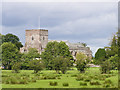
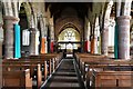
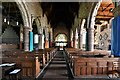
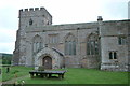
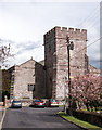
The church of Greystoke nearby is a large, imposing building, first recorded in 1255, when it was "second only in that respect to the Cathedral" (of Carlisle).
You may be viewing yesterday's version of this page. To see the most up to date information please register for a free account.
 (PID:201932)")
 (PID:201930)")
Do not use the above information on other web sites or publications without permission of the contributor.
Nearby Images from Geograph Britain and Ireland:
©2007(licence)
©2019(licence)
©2019(licence)
©2012(licence)
©2015(licence)
The above images may not be of the site on this page, they are loaded from Geograph.
Please Submit an Image of this site or go out and take one for us!
Click here to see more info for this site
Nearby sites
Key: Red: member's photo, Blue: 3rd party photo, Yellow: other image, Green: no photo - please go there and take one, Grey: site destroyed
Download sites to:
KML (Google Earth)
GPX (GPS waypoints)
CSV (Garmin/Navman)
CSV (Excel)
To unlock full downloads you need to sign up as a Contributory Member. Otherwise downloads are limited to 50 sites.
Turn off the page maps and other distractions
Nearby sites listing. In the following links * = Image available
333m WNW 284° Greystoke Village Cross* Ancient Cross (NY4401230870)
369m SW 219° Eye Keld Well* Holy Well or Sacred Spring (NY441305)
2.2km E 91° Kells Well (Newbeggin)* Holy Well or Sacred Spring (NY4654330728)
2.8km W 280° Berrier Hill Earthworks Misc. Earthwork (NY416313)
2.9km SSW 208° Motherby (Cumbria)* Holy Well or Sacred Spring (NY4293428212)
3.1km ESE 118° Newbeggin Stone Row (Stone 3)* Standing Stone (Menhir) (NY4703929314)
3.1km ESE 119° Newbeggin Stone Row (Stone 2)* Standing Stone (Menhir) (NY4705629248)
3.1km SE 126° Newbeggin Stone Row (Stone 5)* Standing Stone (Menhir) (NY4684928893)
3.2km ESE 118° Newbeggin Stone Row* Stone Row / Alignment (NY47122929)
3.2km ESE 117° Newbeggin Stone Row (Stone 1)* Standing Stone (Menhir) (NY4712629292)
3.2km SE 125° Newbeggin Stone Row (Stone 4)* Standing Stone (Menhir) (NY4692428953)
3.2km ENE 77° Newton Reigny Stone Row / Alignment (NY475315)
3.3km ESE 122° Newbeggin Wells* Holy Well or Sacred Spring (NY47122902)
3.3km ESE 122° Newbeggin Stone Row (Blue Stone)* Natural Stone / Erratic / Other Natural Feature (NY4713029010)
3.5km SW 223° Penruddock Stone Circle (NY419282)
3.5km SW 223° Motherby Stone Circle (NY419282)
3.9km ENE 77° Newton Reigny Enclosure* Misc. Earthwork (NY4814031590)
3.9km E 92° Mossthorn Long Cairn 1* Cairn (NY4825830606)
3.9km ESE 108° Newbeggin Stone Row (Possible)* Standing Stone (Menhir) (NY4805829531)
4.0km E 94° Mossthorn Long Cairn 2* Cairn (NY4828930440)
4.5km SSE 157° Dacre Church* Ancient Cross (NY46002664)
4.6km E 99° Sewborrans Stone* Standing Stone (Menhir) (NY48842999)
5.7km SE 126° Snuff Mill (Stainton)* Standing Stone (Menhir) (NY4890927405)
5.8km ESE 106° Bell Mount* Natural Stone / Erratic / Other Natural Feature (NY49932914)
5.9km ESE 121° Dacre Parish* Stone Circle (NY49342771)
View more nearby sites and additional images


 We would like to know more about this location. Please feel free to add a brief description and any relevant information in your own language.
 Wir möchten mehr über diese Stätte erfahren. Bitte zögern Sie nicht, eine kurze Beschreibung und relevante Informationen in Deutsch hinzuzufügen.
 Nous aimerions en savoir encore un peu sur les lieux. S'il vous plaît n'hesitez pas à ajouter une courte description et tous les renseignements pertinents dans votre propre langue.
 Quisieramos informarnos un poco más de las lugares. No dude en añadir una breve descripción y otros datos relevantes en su propio idioma.