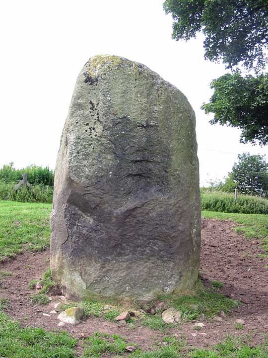
<< Our Photo Pages >> Lowhouse - Stone Circle in England in Cumbria
Submitted by Tom_Bullock on Saturday, 17 July 2004 Page Views: 11133
Neolithic and Bronze AgeSite Name: Lowhouse Alternative Name: Holme Head; KitchenshillCountry: England County: Cumbria Type: Stone Circle
Nearest Town: Penrith
Map Ref: NY49623435 Landranger Map Number: 90
Latitude: 54.701640N Longitude: 2.783289W
Condition:
| 5 | Perfect |
| 4 | Almost Perfect |
| 3 | Reasonable but with some damage |
| 2 | Ruined but still recognisable as an ancient site |
| 1 | Pretty much destroyed, possibly visible as crop marks |
| 0 | No data. |
| -1 | Completely destroyed |
| 5 | Superb |
| 4 | Good |
| 3 | Ordinary |
| 2 | Not Good |
| 1 | Awful |
| 0 | No data. |
| 5 | Can be driven to, probably with disabled access |
| 4 | Short walk on a footpath |
| 3 | Requiring a bit more of a walk |
| 2 | A long walk |
| 1 | In the middle of nowhere, a nightmare to find |
| 0 | No data. |
| 5 | co-ordinates taken by GPS or official recorded co-ordinates |
| 4 | co-ordinates scaled from a detailed map |
| 3 | co-ordinates scaled from a bad map |
| 2 | co-ordinates of the nearest village |
| 1 | co-ordinates of the nearest town |
| 0 | no data |
Internal Links:
External Links:
I have visited· I would like to visit
SumDoood Monocular71 would like to visit
Anne T visited on 12th Feb 2017 - their rating: Cond: 3 Amb: 3 Access: 4 Lowhouse/Holme Head/Kitchenhill Standing Stone, Penrith, Cumbria: From Newbeggin, heading back up the M6, leaving at junction 41, turning right onto the B5305 and taking the first exit off the roundabout, we headed up the minor road signposted to Calthwaite. Where the road divides at Kitchenhill Farm, we turned right, heading over the railway line, then immediately over the small bridge over the River Petterill. At grid reference NY 49802 34135 there is a left hand turn on the bend, leading down to a small area of land by the river, used by the farmer for storing hay. There is room here for one car to park at the entrance. We walked back the short distance over the bridge over the river and went to look over the gate into the field. At first, in the gathering dusk, we couldn’t see anything, but then at the far end of the field, sheltered by a large tree, we spotted this huge grey stone.
The field is guarded by a barbed wire topped gate. I don’t like trespassing, but there was nothing in the field, so we let ourselves gingerly in and followed the tractor trail over the grass to the stone. It is huge. I spotted what seemed like other smaller (grey) stones in the base of the red sandstone wall to the right-hand side of the field. Getting closer to the stone, it sits on (what was) a lovely spot (pre railway line), overlooking the gently meandering river below.
Andrew was keen to try and get sight of two other stones in the area (and another I’d spotted travelling south on the M6 on the way down), so we drove to Plumpton, slightly further north, stopping near Plumpton Wall Farm to peer over the fields, but could see nothing. We retraced our route and headed off towards Calthwaite, stopping at the entrance to Hallrigg to peer eastwards over the fields. With the sleet hammering in our faces, Andrew got the binoculars out and spotted a stone next to Calgarth Plantation at grid reference NY 48253 37527. Looking on UK Grid Reference Finder, I couldn’t see any sign of it, although this is an old map on the Modern Antiquarian web site which would be worth investigating.
nicoladidsbury have visited here

Recorded as Historic England site 1018363, this prehistoric standing stone is "stone located on gently sloping ground a short distance east of the west coast main line railway 260m north west of Kitchenhill Bridge. The granite stone is roughly rectangular and measures approximately 1.5m by 1.3m and up to 3m high. A number of packing stones are visible at the standing stone's base."
Also recorded as Pastscape Monument 11288, they say the site might show the outline of a lost stone circle.
Parking near Kitchenhill Bridge, walk back over the River Petterill (if you get to the bridge over the railway line, you have gone too far). To your right hand side, there is a gate topped with barbed wire which leads into a triangular shaped field. The stone sits some 200 metres or so at the far side of this field. The stone is sheltered by a large tree, almost next to the main West Coast railway line.
You may be viewing yesterday's version of this page. To see the most up to date information please register for a free account.


Do not use the above information on other web sites or publications without permission of the contributor.
Click here to see more info for this site
Nearby sites
Key: Red: member's photo, Blue: 3rd party photo, Yellow: other image, Green: no photo - please go there and take one, Grey: site destroyed
Download sites to:
KML (Google Earth)
GPX (GPS waypoints)
CSV (Garmin/Navman)
CSV (Excel)
To unlock full downloads you need to sign up as a Contributory Member. Otherwise downloads are limited to 50 sites.
Turn off the page maps and other distractions
Nearby sites listing. In the following links * = Image available
3.1km SSW 208° Newton Reigny Enclosure* Misc. Earthwork (NY4814031590)
3.3km NNW 342° Hallrigg Standing Stone* Standing Stone (Menhir) (NY4865737482)
3.5km SW 216° Newton Reigny Stone Row / Alignment (NY475315)
4.0km SSW 199° Mossthorn Long Cairn 1* Cairn (NY4825830606)
4.1km SSW 198° Mossthorn Long Cairn 2* Cairn (NY4828930440)
4.4km SSE 155° Penrith Museum* Museum (NY5144830339)
4.4km S 189° Sewborrans Stone* Standing Stone (Menhir) (NY48842999)
4.6km SSE 154° Giants Grave, Penrith* Ancient Cross (NY51653017)
4.7km SW 220° Kells Well (Newbeggin)* Holy Well or Sacred Spring (NY4654330728)
5.1km SE 136° Dickey Bank Holy Well (Carleton Hill) Holy Well or Sacred Spring (NY5309030660)
5.1km SSW 197° Newbeggin Stone Row (Possible)* Standing Stone (Menhir) (NY4805829531)
5.2km S 176° Bell Mount* Natural Stone / Erratic / Other Natural Feature (NY49932914)
5.3km SSE 153° Plague Stone (Penrith)* Ancient Cross (NY5196329563)
5.6km SSW 206° Newbeggin Stone Row (Stone 1)* Standing Stone (Menhir) (NY4712629292)
5.6km SSW 206° Newbeggin Stone Row* Stone Row / Alignment (NY47122929)
5.7km SSW 206° Newbeggin Stone Row (Stone 3)* Standing Stone (Menhir) (NY4703929314)
5.7km SSW 206° Newbeggin Stone Row (Stone 2)* Standing Stone (Menhir) (NY4705629248)
5.8km SSE 166° Skirsgill Standing Stone* Standing Stone (Menhir) (NY50972875)
5.9km SSW 204° Newbeggin Wells* Holy Well or Sacred Spring (NY47122902)
5.9km SSW 204° Newbeggin Stone Row (Blue Stone)* Natural Stone / Erratic / Other Natural Feature (NY4713029010)
5.9km SSE 166° Skirsgill Holy Well (Skirsgill) Holy Well or Sacred Spring (NY5095028560)
6.0km SSW 206° Newbeggin Stone Row (Stone 4)* Standing Stone (Menhir) (NY4692428953)
6.1km SSW 206° Newbeggin Stone Row (Stone 5)* Standing Stone (Menhir) (NY4684928893)
6.3km SSE 158° Mayburgh* Henge (NY5191728428)
6.4km SW 235° Sanctuary Stone (Greystoke)* Early Christian Sculptured Stone (NY4433530785)
View more nearby sites and additional images


 We would like to know more about this location. Please feel free to add a brief description and any relevant information in your own language.
 Wir möchten mehr über diese Stätte erfahren. Bitte zögern Sie nicht, eine kurze Beschreibung und relevante Informationen in Deutsch hinzuzufügen.
 Nous aimerions en savoir encore un peu sur les lieux. S'il vous plaît n'hesitez pas à ajouter une courte description et tous les renseignements pertinents dans votre propre langue.
 Quisieramos informarnos un poco más de las lugares. No dude en añadir una breve descripción y otros datos relevantes en su propio idioma.