


<< Text Pages >> Barton Cross - Ancient Cross in England in Lancashire
Submitted by Anne T on Monday, 11 February 2019 Page Views: 1269
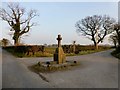
Early Medieval (Dark Age)Site Name: Barton CrossCountry: England County: Lancashire Type: Ancient Cross
Nearest Town: Preston Nearest Village: Barton
Map Ref: SD5350037332
Latitude: 53.830157N Longitude: 2.707981W
Condition:
| 5 | Perfect |
| 4 | Almost Perfect |
| 3 | Reasonable but with some damage |
| 2 | Ruined but still recognisable as an ancient site |
| 1 | Pretty much destroyed, possibly visible as crop marks |
| 0 | No data. |
| -1 | Completely destroyed |
| 5 | Superb |
| 4 | Good |
| 3 | Ordinary |
| 2 | Not Good |
| 1 | Awful |
| 0 | No data. |
| 5 | Can be driven to, probably with disabled access |
| 4 | Short walk on a footpath |
| 3 | Requiring a bit more of a walk |
| 2 | A long walk |
| 1 | In the middle of nowhere, a nightmare to find |
| 0 | No data. |
| 5 | co-ordinates taken by GPS or official recorded co-ordinates |
| 4 | co-ordinates scaled from a detailed map |
| 3 | co-ordinates scaled from a bad map |
| 2 | co-ordinates of the nearest village |
| 1 | co-ordinates of the nearest town |
| 0 | no data |
Be the first person to rate this site - see the 'Contribute!' box in the right hand menu.
Internal Links:
External Links:
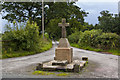
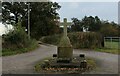
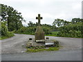
Ancient Cross with Cup Marked Stone in Lancashire
This cross is recorded as Historic England List ID 1073555, which tells us this cross was re-erected here in 1901 on the base of a former cross which dates to the late medieval and which is sited at the junction of an old track which runs north-south. Part of the base, a large cubic block, is thought to have been part of a cheese press.
This cross is also featured on The Northern Antiquarian (TNA) - see their entry for the Barton Cross, Barton, Preston, Lancashire. TNA adds: "one of the paving stones that surround the cross has prehistoric cup marking on it", which is described and photographed on their entry for the Barton Cross Stone, Barton, Lancashire, the stone "likely having been removed from another locality and cut to shape to form part of the surrounding platform base". The stone has ten cup marks.
The Journal of Antiquities also includes an entry for this cross with its cup marked stone - see their page for the Barton Cross Cup-Marked Stone, Near Preston, Lancashire. The Journal has directions for finding this cross, photographs both of the cross, its base and the cup marked stone, plus a list of reference sources for more information.
Note: Have you visited this site? Do you have any photographs or information to add?
You may be viewing yesterday's version of this page. To see the most up to date information please register for a free account.
Do not use the above information on other web sites or publications without permission of the contributor.
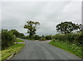
Nearby Images from Geograph Britain and Ireland:
©2010(licence)
©2014(licence)
©2022(licence)
©2010(licence)
©2013(licence)
The above images may not be of the site on this page, they are loaded from Geograph.
Please Submit an Image of this site or go out and take one for us!
Click here to see more info for this site
Nearby sites
Key: Red: member's photo, Blue: 3rd party photo, Yellow: other image, Green: no photo - please go there and take one, Grey: site destroyed
Download sites to:
KML (Google Earth)
GPX (GPS waypoints)
CSV (Garmin/Navman)
CSV (Excel)
To unlock full downloads you need to sign up as a Contributory Member. Otherwise downloads are limited to 50 sites.
Turn off the page maps and other distractions
Nearby sites listing. In the following links * = Image available
2.2km NNE 32° St Anne's Well (Inglewhite)* Holy Well or Sacred Spring (SD547392)
4.3km SSE 150° Our Lady's Well, Fernyhalgh* Holy Well or Sacred Spring (SD55613362)
5.6km NNW 336° Claughton Hlaew* Round Barrow(s) (SD51274247)
6.9km NW 321° Catterall Cross* Ancient Cross (SD4920242700)
7.6km NW 315° Medieval Grave Covers (Churchtown)* Sculptured Stone (SD4818242808)
8.0km S 176° Minspit Well (Preston) Holy Well or Sacred Spring (SD540293)
8.3km S 187° Penwortham Castle Hillfort (SD5243429062)
8.8km S 187° St Mary's Well (Penwortham) Holy Well or Sacred Spring (SD5232328579)
9.0km SE 127° Marsden Well/Spring* Holy Well or Sacred Spring (SD607319)
9.1km E 86° The Written Stone* Sculptured Stone (SD6262237892)
9.6km NNE 25° Bleasdale* Timber Circle (SD5771145994)
9.8km NE 38° Parlick Pike Cairn* Cairn (SD59574502)
10.1km SSW 195° Howick Cross* Ancient Cross (SD5081927574)
10.3km NNW 334° Roman Milestone (Garstang)* Marker Stone (SD4907146676)
11.3km ENE 74° Jeffrey Hill Cairn Circle* Cairn (SD644404)
11.4km ENE 73° Thornley Hall Fell Cairn* Round Barrow(s) (SD64524047)
11.6km E 101° St Wilfrid's Church (Ribchester)* Ancient Cross (SD649350)
11.9km E 96° St Saviour's Churchyard (Stydd) Ancient Cross (SD6539435971)
13.2km ESE 118° Mellor Brow Mound* Misc. Earthwork (SD6517231081)
13.9km SSE 163° Hawksclough Hillfort (SD574240)
15.2km SE 131° Pleasington Cemetery (Blackburn) Cairn (SD649272)
15.3km NE 51° Fairy Holes* Cave or Rock Shelter (SD65534678)
15.3km ESE 119° Beardwood Holed Stone* Holed Stone (SD6684829793)
15.4km ENE 78° Kemple End Cross* Ancient Cross (SD6864240438)
15.7km S 178° Leyland Town Cross Ancient Cross (SD5400221602)
View more nearby sites and additional images


 We would like to know more about this location. Please feel free to add a brief description and any relevant information in your own language.
 Wir möchten mehr über diese Stätte erfahren. Bitte zögern Sie nicht, eine kurze Beschreibung und relevante Informationen in Deutsch hinzuzufügen.
 Nous aimerions en savoir encore un peu sur les lieux. S'il vous plaît n'hesitez pas à ajouter une courte description et tous les renseignements pertinents dans votre propre langue.
 Quisieramos informarnos un poco más de las lugares. No dude en añadir una breve descripción y otros datos relevantes en su propio idioma.