


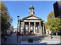
<< Our Photo Pages >> Lancaster City Museum - Museum in England in Lancashire
Submitted by vicky on Saturday, 30 November 2002 Page Views: 6562
MuseumsSite Name: Lancaster City MuseumCountry: England
NOTE: This site is 0.302 km away from the location you searched for.
County: Lancashire Type: Museum
Nearest Town: Lancaster
Map Ref: SD4761161729 Landranger Map Number: 97
Latitude: 54.048848N Longitude: 2.801641W
Condition:
| 5 | Perfect |
| 4 | Almost Perfect |
| 3 | Reasonable but with some damage |
| 2 | Ruined but still recognisable as an ancient site |
| 1 | Pretty much destroyed, possibly visible as crop marks |
| 0 | No data. |
| -1 | Completely destroyed |
| 5 | Superb |
| 4 | Good |
| 3 | Ordinary |
| 2 | Not Good |
| 1 | Awful |
| 0 | No data. |
| 5 | Can be driven to, probably with disabled access |
| 4 | Short walk on a footpath |
| 3 | Requiring a bit more of a walk |
| 2 | A long walk |
| 1 | In the middle of nowhere, a nightmare to find |
| 0 | No data. |
| 5 | co-ordinates taken by GPS or official recorded co-ordinates |
| 4 | co-ordinates scaled from a detailed map |
| 3 | co-ordinates scaled from a bad map |
| 2 | co-ordinates of the nearest village |
| 1 | co-ordinates of the nearest town |
| 0 | no data |
Be the first person to rate this site - see the 'Contribute!' box in the right hand menu.
Internal Links:
External Links:
I have visited· I would like to visit
AmyBlahBlahBlah would like to visit
")
The history of the town from 12,000 years ago to the 1960s.
Address: Market Square, LA1 1HT
Phone: 01524 64637
Opening Hours: Open Monday to Saturday 1Oam - 5pm
Admission: Free
Website: Lancaster City Museum
You may be viewing yesterday's version of this page. To see the most up to date information please register for a free account.
Do not use the above information on other web sites or publications without permission of the contributor.
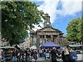
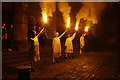
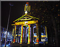
Nearby Images from Geograph Britain and Ireland:
©2023(licence)
©2013(licence)
©2014(licence)
©2016(licence)

©2013(licence)
The above images may not be of the site on this page, they are loaded from Geograph.
Please Submit an Image of this site or go out and take one for us!
Click here to see more info for this site
Nearby sites
Key: Red: member's photo, Blue: 3rd party photo, Yellow: other image, Green: no photo - please go there and take one, Grey: site destroyed
Download sites to:
KML (Google Earth)
GPX (GPS waypoints)
CSV (Garmin/Navman)
CSV (Excel)
To unlock full downloads you need to sign up as a Contributory Member. Otherwise downloads are limited to 50 sites.
Turn off the page maps and other distractions
Nearby sites listing. In the following links * = Image available
271m NW 308° Lancaster Priory Cross* Ancient Cross (SD474619)
1.2km ESE 116° Golgotha Lodge (Williamson Park) Cairn (SD48666121)
3.0km NW 326° Torrisholme* Round Barrow(s) (SD45966425)
3.7km NE 37° Halton St Wilfrid's Churchyard* Ancient Cross (SD49916469)
4.2km NE 41° The Lancaster Cross* Ancient Cross (SD504649)
5.0km NW 310° Fartle Barrow* Cairn (SD4380364966)
5.1km E 82° Askew Heights* Ancient Village or Settlement (SD52726239)
6.0km N 6° Bolton Le Sands Early Christian Sculptured Stone (SD48336765)
6.1km W 261° Church Well (Heysham) Holy Well or Sacred Spring (SD416609)
6.1km NNE 13° Bolton-le-Sands Barrow* Ring Cairn (SD4901467624)
6.1km N 6° St Michael's Well (Lancashire) Holy Well or Sacred Spring (SD4828567831)
6.5km W 268° St Patrick's Well (Heysham)* Holy Well or Sacred Spring (SD4108961591)
6.5km W 268° Heysham St Peter's Churchyard* Ancient Cross (SD41066161)
6.6km W 269° Heysham Rock-Cut tombs* Rock Cut Tomb (SD4098461655)
6.9km W 268° Heysham Labyrinth* Carving (SD407616)
9.0km N 8° Hunting Hill* Round Barrow(s) (SD49037065)
10.2km N 3° Cote Stones Cairn (SD482719)
11.1km N 8° Warton Crag* Hillfort (SD492727)
11.1km N 2° Badger Hole (Lancashire)* Cave or Rock Shelter (SD48187285)
11.3km N 1° Ings Point Natural Stone / Erratic / Other Natural Feature (SD479730)
11.3km N 3° Dog Holes* Cave or Rock Shelter (SD48337303)
11.6km N 11° Warton Crag giant wall Misc. Earthwork (SD499731)
11.9km N 8° The Three brothers* Natural Stone / Erratic / Other Natural Feature (SD495735)
12.1km NNE 23° Manor Farm* Round Barrow(s) (SD52387285)
12.4km N 352° Woodwell* Holy Well or Sacred Spring (SD4674)
View more nearby sites and additional images


 We would like to know more about this location. Please feel free to add a brief description and any relevant information in your own language.
 Wir möchten mehr über diese Stätte erfahren. Bitte zögern Sie nicht, eine kurze Beschreibung und relevante Informationen in Deutsch hinzuzufügen.
 Nous aimerions en savoir encore un peu sur les lieux. S'il vous plaît n'hesitez pas à ajouter une courte description et tous les renseignements pertinents dans votre propre langue.
 Quisieramos informarnos un poco más de las lugares. No dude en añadir una breve descripción y otros datos relevantes en su propio idioma.