

<< Our Photo Pages >> Venta Silurum Settlement - Ancient Village or Settlement in Wales in Monmouthshire
Submitted by TAlanJones on Wednesday, 23 February 2022 Page Views: 742
Roman, Greek and ClassicalSite Name: Venta Silurum Settlement Alternative Name: CaerwentCountry: Wales County: Monmouthshire Type: Ancient Village or Settlement
Nearest Town: Newport Nearest Village: Caerwent
Map Ref: ST46959056
Latitude: 51.611358N Longitude: 2.767516W
Condition:
| 5 | Perfect |
| 4 | Almost Perfect |
| 3 | Reasonable but with some damage |
| 2 | Ruined but still recognisable as an ancient site |
| 1 | Pretty much destroyed, possibly visible as crop marks |
| 0 | No data. |
| -1 | Completely destroyed |
| 5 | Superb |
| 4 | Good |
| 3 | Ordinary |
| 2 | Not Good |
| 1 | Awful |
| 0 | No data. |
| 5 | Can be driven to, probably with disabled access |
| 4 | Short walk on a footpath |
| 3 | Requiring a bit more of a walk |
| 2 | A long walk |
| 1 | In the middle of nowhere, a nightmare to find |
| 0 | No data. |
| 5 | co-ordinates taken by GPS or official recorded co-ordinates |
| 4 | co-ordinates scaled from a detailed map |
| 3 | co-ordinates scaled from a bad map |
| 2 | co-ordinates of the nearest village |
| 1 | co-ordinates of the nearest town |
| 0 | no data |
Internal Links:
External Links:
")
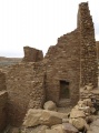
This was a town defended by high walls that surrounded the town in a rectangle. The town itself was spread out in a typically Roman well ordered grid, complete with public baths and areas of commerce and administration. The town has attracted a lot of interest from archaeologists over the years. Historic remains include the defensive walls still standing that reach an impressive 5m in height.
This is an impressive site that has many aspects to it including the excavated remains of houses and streets, a cult temple, a forum basilica, markets and workshops. However, it receives far less attention than it deserves. Hidden away along the A48 this historic town loses out to its more popular Roman neighbour 'Isca' (Caerleon ) with its massive fort and amphitheatre.
You may be viewing yesterday's version of this page. To see the most up to date information please register for a free account.
")
")
")
")
")
Do not use the above information on other web sites or publications without permission of the contributor.
Click here to see more info for this site
Nearby sites
Key: Red: member's photo, Blue: 3rd party photo, Yellow: other image, Green: no photo - please go there and take one, Grey: site destroyed
Download sites to:
KML (Google Earth)
GPX (GPS waypoints)
CSV (Garmin/Navman)
CSV (Excel)
To unlock full downloads you need to sign up as a Contributory Member. Otherwise downloads are limited to 50 sites.
Turn off the page maps and other distractions
Nearby sites listing. In the following links * = Image available
9m ENE 63° Cult Temple at Venta Silurum* Ancient Temple (ST4695890564)
106m SW 228° Silurum Stone Marker Stone (ST46879049)
1.5km E 101° Crick Round Barrow* Round Barrow(s) (ST48449025)
1.5km W 267° Middle Hendre Round Barrow(s) (ST454905)
2.0km W 279° Five Lanes Round Barrow (B) Round Barrow(s) (ST45019090)
2.0km W 280° Five Lanes Round Barrow (A) Round Barrow(s) (ST45019091)
2.2km NNW 337° Llanmelin Wood* Hillfort (ST46109260)
2.3km NNW 343° Llan-melin wood Earthwork Misc. Earthwork (ST463928)
2.5km WSW 259° Woodcock Hill Barrow Round Barrow(s) (ST44449008)
2.6km E 91° Mathern Round Barrow(s) (ST496905)
3.3km SSW 213° Llanfihangel Rogiet Churchyard Cross* Ancient Cross (ST4512087850)
3.6km W 266° Carrow Hill Round Barrow Round Barrow(s) (ST43309035)
3.7km W 261° The Larches Camp* Hillfort (ST433900)
3.7km SW 220° Llanfihangel Rogiet* Standing Stone (Menhir) (ST44518775)
3.8km SE 129° Portskewett Chutchyard Cross* Ancient Cross (ST4990088140)
3.9km ENE 65° Willis Hill Ancient Village or Settlement (ST50519216)
3.9km NW 313° Gray Hill Cairn Cemetery* Barrow Cemetery (ST4408693273)
4.0km W 265° Carrow Hill Round Barrow Pair Round Barrow(s) (ST42999029)
4.0km ESE 117° Heston Brake* Chambered Tomb (ST50528866)
4.3km SE 142° Caldicot Pill Submerged Forest Natural Stone / Erratic / Other Natural Feature (ST4956687114)
4.3km NW 313° Gray Hill circle* Stone Circle (ST43809353)
4.3km SW 220° Undy Earthwork Misc. Earthwork (ST441873)
4.3km SSE 156° Caldicot Castle* Ancient Trackway (ST487866)
4.4km NW 313° Gray Hill stone row* Standing Stone (Menhir) (ST43769357)
4.6km NW 309° Gray Hill summit cairn* Round Cairn (ST43399355)
View more nearby sites and additional images


 We would like to know more about this location. Please feel free to add a brief description and any relevant information in your own language.
 Wir möchten mehr über diese Stätte erfahren. Bitte zögern Sie nicht, eine kurze Beschreibung und relevante Informationen in Deutsch hinzuzufügen.
 Nous aimerions en savoir encore un peu sur les lieux. S'il vous plaît n'hesitez pas à ajouter une courte description et tous les renseignements pertinents dans votre propre langue.
 Quisieramos informarnos un poco más de las lugares. No dude en añadir una breve descripción y otros datos relevantes en su propio idioma.