


<< Our Photo Pages >> Irthington Mill - Misc. Earthwork in England in Cumbria
Submitted by Anne T on Friday, 25 August 2017 Page Views: 1305
Multi-periodSite Name: Irthington MillCountry: England
NOTE: This site is 0.813 km away from the location you searched for.
County: Cumbria Type: Misc. Earthwork
Nearest Town: Carlisle Nearest Village: Newtown
Map Ref: NY50776237
Latitude: 54.953531N Longitude: 2.770225W
Condition:
| 5 | Perfect |
| 4 | Almost Perfect |
| 3 | Reasonable but with some damage |
| 2 | Ruined but still recognisable as an ancient site |
| 1 | Pretty much destroyed, possibly visible as crop marks |
| 0 | No data. |
| -1 | Completely destroyed |
| 5 | Superb |
| 4 | Good |
| 3 | Ordinary |
| 2 | Not Good |
| 1 | Awful |
| 0 | No data. |
| 5 | Can be driven to, probably with disabled access |
| 4 | Short walk on a footpath |
| 3 | Requiring a bit more of a walk |
| 2 | A long walk |
| 1 | In the middle of nowhere, a nightmare to find |
| 0 | No data. |
| 5 | co-ordinates taken by GPS or official recorded co-ordinates |
| 4 | co-ordinates scaled from a detailed map |
| 3 | co-ordinates scaled from a bad map |
| 2 | co-ordinates of the nearest village |
| 1 | co-ordinates of the nearest town |
| 0 | no data |
Internal Links:
External Links:
I have visited· I would like to visit
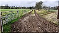
Anne T visited on 20th Aug 2017 - their rating: Cond: 2 Amb: 3 Access: 5 Irthington Mill 'motte or not?': Having spotted two mottes and a holy well just off the road we were travelling on to Carlisle, I asked to take a detour to find these. Whilst this is marked as a motte on the OS map, and certainly looked like one, I got home to find there is some debate about whether this is a motte or a natural feature (it is not recorded on Historic England’s listings).
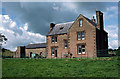
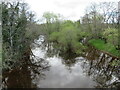
Situated between a farm with some very old buildings and Irthington Mill house, with part of the Mill’s garden growing up its western slope, and not far from Irthington Bridge, it seemed to me that this motte was in a much more strategic defensible position near the modern day river crossing. Perhaps the course of the river moved over the years and the site of the motte was changed? This is me not wanting to belive its just a natural feature!
")
Having visited the nearby village of Walton to find the remains of their ancient cross, I spotted two mottes and a holy well marked on the OS map which were very close together, so we took a slight detour off the B6071 towards Irthington to find where these were located.
There seems to be debate about whether this feature is a motte or if it is a natural feature. Pastscape Monument No. 12769. They record the mound allegedly dates to the 12th century and measures 3.5 metres high by 48 metres long and 29 metres wide, orientated roughly east/west but with no associated bailey.
To me, this motte sits is a better defensive position near the River Irthing, near the modern day bridge which crosses the River Irthing. I wondered if the course of the river had changed over the years and they had relocated the motte accordingly. As Pastscape says, "there would not to be mottes so close together in the same manor."
You may be viewing yesterday's version of this page. To see the most up to date information please register for a free account.
")
")
Do not use the above information on other web sites or publications without permission of the contributor.
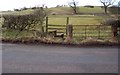
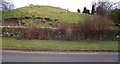
Nearby Images from Geograph Britain and Ireland:
©2006(licence)
©2006(licence)
©2009(licence)
©2022(licence)
©2023(licence)
The above images may not be of the site on this page, they are loaded from Geograph.
Please Submit an Image of this site or go out and take one for us!
Click here to see more info for this site
Nearby sites
Key: Red: member's photo, Blue: 3rd party photo, Yellow: other image, Green: no photo - please go there and take one, Grey: site destroyed
Download sites to:
KML (Google Earth)
GPX (GPS waypoints)
CSV (Garmin/Navman)
CSV (Excel)
To unlock full downloads you need to sign up as a Contributory Member. Otherwise downloads are limited to 50 sites.
Turn off the page maps and other distractions
Nearby sites listing. In the following links * = Image available
1.1km SW 228° Hall Well (Irthington)* Holy Well or Sacred Spring (NY4992361627)
1.2km SW 224° Irthington Motte* Misc. Earthwork (NY49936151)
2.6km NNE 33° St Mary's Church (Walton)* Ancient Cross (NY5220864492)
2.8km ESE 112° Brampton Castle Mound and Well* Misc. Earthwork (NY5333261284)
2.9km W 269° Chapel Well (Irthington) Holy Well or Sacred Spring (NY4791062345)
5.2km SW 217° Cardinal Well (Irthington) Holy Well or Sacred Spring (NY4755058220)
7.0km ENE 70° Banks East Ancient Village or Settlement (NY574647)
8.4km SSW 208° St Cuthbert's Holy Well* Holy Well or Sacred Spring (NY46735496)
8.6km SE 133° Talkin Fell Cairns* Modern Stone Circle etc (NY5701356379)
8.8km SE 133° Glendue Burn Standing Stone* Standing Stone (Menhir) (NY571563)
8.8km N 357° Bride's Well (Stapleton)* Holy Well or Sacred Spring (NY50397119)
8.9km SSW 206° Anglo Saxon Cross Base, Wetheral Parish Church* Ancient Cross (NY46835436)
9.0km SSW 207° Wetheral Village Cross* Ancient Cross (NY4665954370)
9.4km NNE 30° Askerton Park* Ancient Village or Settlement (NY55567053)
9.7km S 169° Carlatton Demesne* Standing Stone (Menhir) (NY5252352810)
9.9km ESE 107° Tarnhouse Rigg Standing Stone (Menhir) (NY602593)
10.5km NE 36° Gillalees Ring Cairn (NY571708)
10.6km NE 55° Waterhead Holy Well (King Water)* Holy Well or Sacred Spring (NY5951068340)
11.5km S 173° Chapel Well (Cumwhitton) Holy Well or Sacred Spring (NY5209050930)
11.5km NE 36° Robin Hood's Well (Askerton) Holy Well or Sacred Spring (NY57677161)
11.6km WSW 242° Homeacres Holy Well (Stanwix)* Holy Well or Sacred Spring (NY40415709)
11.7km SSE 166° Carlatton Stone Row Stone Row / Alignment (NY534510)
12.1km NNE 30° Towerbrae Cairn* Cairn (NY56867282)
12.3km WSW 243° Hyssop Holme Well (Carlisle)* Holy Well or Sacred Spring (NY3974856801)
12.4km WSW 238° Carlisle Cross* Ancient Cross (NY4008455931)
View more nearby sites and additional images


 We would like to know more about this location. Please feel free to add a brief description and any relevant information in your own language.
 Wir möchten mehr über diese Stätte erfahren. Bitte zögern Sie nicht, eine kurze Beschreibung und relevante Informationen in Deutsch hinzuzufügen.
 Nous aimerions en savoir encore un peu sur les lieux. S'il vous plaît n'hesitez pas à ajouter une courte description et tous les renseignements pertinents dans votre propre langue.
 Quisieramos informarnos un poco más de las lugares. No dude en añadir una breve descripción y otros datos relevantes en su propio idioma.