


<< Our Photo Pages >> Portishead Churchyard Cross - Ancient Cross in England in Somerset
Submitted by dooclay on Thursday, 06 July 2023 Page Views: 270
Early Medieval (Dark Age)Site Name: Portishead Churchyard CrossCountry: England
NOTE: This site is 0.647 km away from the location you searched for.
County: Somerset Type: Ancient Cross
Nearest Village: Portishead
Map Ref: ST4662476000
Latitude: 51.480424N Longitude: 2.77001W
Condition:
| 5 | Perfect |
| 4 | Almost Perfect |
| 3 | Reasonable but with some damage |
| 2 | Ruined but still recognisable as an ancient site |
| 1 | Pretty much destroyed, possibly visible as crop marks |
| 0 | No data. |
| -1 | Completely destroyed |
| 5 | Superb |
| 4 | Good |
| 3 | Ordinary |
| 2 | Not Good |
| 1 | Awful |
| 0 | No data. |
| 5 | Can be driven to, probably with disabled access |
| 4 | Short walk on a footpath |
| 3 | Requiring a bit more of a walk |
| 2 | A long walk |
| 1 | In the middle of nowhere, a nightmare to find |
| 0 | No data. |
| 5 | co-ordinates taken by GPS or official recorded co-ordinates |
| 4 | co-ordinates scaled from a detailed map |
| 3 | co-ordinates scaled from a bad map |
| 2 | co-ordinates of the nearest village |
| 1 | co-ordinates of the nearest town |
| 0 | no data |
Internal Links:
External Links:
")
Source: Historic England
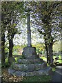
Late Medieval. Octagonal high stepped base; octagonal shaft with square base and restored cross-head with carved panels in C20. A good and substantial surviver of this type.
See Historic England List ID 1291083 for the listing for this cross.
You may be viewing yesterday's version of this page. To see the most up to date information please register for a free account.
Do not use the above information on other web sites or publications without permission of the contributor.
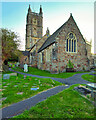
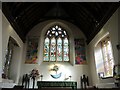
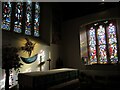
Nearby Images from Geograph Britain and Ireland:
©2022(licence)
©2021(licence)
©2022(licence)
©2022(licence)
©2022(licence)
The above images may not be of the site on this page, they are loaded from Geograph.
Please Submit an Image of this site or go out and take one for us!
Click here to see more info for this site
Nearby sites
Key: Red: member's photo, Blue: 3rd party photo, Yellow: other image, Green: no photo - please go there and take one, Grey: site destroyed
Download sites to:
KML (Google Earth)
GPX (GPS waypoints)
CSV (Garmin/Navman)
CSV (Excel)
To unlock full downloads you need to sign up as a Contributory Member. Otherwise downloads are limited to 50 sites.
Turn off the page maps and other distractions
Nearby sites listing. In the following links * = Image available
561m WSW 243° St Mary's Well (Portishead)* Holy Well or Sacred Spring (ST46127575)
1.3km NNE 14° West Hill Fort, Portishead* Hillfort (ST46967726)
1.5km NNE 19° Eastwood Fort, Portishead* Hillfort (ST47157745)
1.6km N 352° Battery Point* Modern Stone Circle etc (ST46437756)
3.3km SSW 197° West Park Wood Standing Stone* Modern Stone Circle etc (ST4564072821)
3.4km ESE 105° Conygar Hillfort Hillfort (ST49897509)
3.7km E 99° Portbury* Standing Stone (Menhir) (ST50277538)
3.7km SSW 198° Cadbury Camp* Hillfort (ST45427245)
4.4km SSE 168° Whirley Pool* Holy Well or Sacred Spring (ST475717)
4.4km WSW 238° Walton-in-Gordano Banjo Enclosure* Misc. Earthwork (ST42847373)
4.7km S 190° Tickenham Churchyard Cross* Ancient Cross (ST4576771428)
4.7km SSE 149° Wraxhall Churchyard Cross* Ancient Cross (ST4902371945)
4.8km SW 217° Tickenham Court Barrow* Round Barrow(s) (ST43697219)
6.1km S 180° Nailsea Churchyard Cross* Ancient Cross (ST4660869917)
6.6km WSW 239° Walton St Mary Cross Ancient Cross (ST4096172635)
6.8km SE 126° Wraxall Camp* Ancient Village or Settlement (ST52057193)
7.3km ESE 113° Snake's Well and Spring* Holy Well or Sacred Spring (ST53287308)
7.6km S 179° Chelvey Churchyard Cross* Ancient Cross (ST4662368354)
7.8km SSE 148° Flax Bourton Ancient Cross* Ancient Cross (ST5066269369)
8.1km ESE 104° Abbots Leigh Churchyard Cross* Ancient Cross (ST5445274007)
8.1km SSE 160° Backwell Church Cross* Ancient Cross (ST4931268323)
8.4km SSE 161° Backwell Cave* Cave or Rock Shelter (ST49246801)
8.4km SSE 160° Backwell Hillfort Hillfort (ST49406805)
8.6km SW 215° Kenn Churchyard Cross* Ancient Cross (ST4159968963)
8.7km ENE 77° King's Weston Hill barrow cemetary* Barrow Cemetery (ST55127793)
View more nearby sites and additional images


 We would like to know more about this location. Please feel free to add a brief description and any relevant information in your own language.
 Wir möchten mehr über diese Stätte erfahren. Bitte zögern Sie nicht, eine kurze Beschreibung und relevante Informationen in Deutsch hinzuzufügen.
 Nous aimerions en savoir encore un peu sur les lieux. S'il vous plaît n'hesitez pas à ajouter une courte description et tous les renseignements pertinents dans votre propre langue.
 Quisieramos informarnos un poco más de las lugares. No dude en añadir una breve descripción y otros datos relevantes en su propio idioma.