


<< Our Photo Pages >> Lazonby Ancient Cross - Ancient Cross in England in Cumbria
Submitted by nicoladidsbury on Saturday, 13 October 2007 Page Views: 5946
Early Medieval (Dark Age)Site Name: Lazonby Ancient Cross Alternative Name: St Nicholas Ancient Cross, LazonbyCountry: England
NOTE: This site is 3.358 km away from the location you searched for.
County: Cumbria Type: Ancient Cross
Nearest Town: Penrith Nearest Village: Lazonby
Map Ref: NY5489039775
Latitude: 54.750889N Longitude: 2.702362W
Condition:
| 5 | Perfect |
| 4 | Almost Perfect |
| 3 | Reasonable but with some damage |
| 2 | Ruined but still recognisable as an ancient site |
| 1 | Pretty much destroyed, possibly visible as crop marks |
| 0 | No data. |
| -1 | Completely destroyed |
| 5 | Superb |
| 4 | Good |
| 3 | Ordinary |
| 2 | Not Good |
| 1 | Awful |
| 0 | No data. |
| 5 | Can be driven to, probably with disabled access |
| 4 | Short walk on a footpath |
| 3 | Requiring a bit more of a walk |
| 2 | A long walk |
| 1 | In the middle of nowhere, a nightmare to find |
| 0 | No data. |
| 5 | co-ordinates taken by GPS or official recorded co-ordinates |
| 4 | co-ordinates scaled from a detailed map |
| 3 | co-ordinates scaled from a bad map |
| 2 | co-ordinates of the nearest village |
| 1 | co-ordinates of the nearest town |
| 0 | no data |
Internal Links:
External Links:
I have visited· I would like to visit
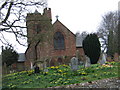
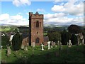
Anne T visited on 30th Nov 2014 - their rating: Cond: 3 Amb: 3 Access: 4 Lazonby Cross, Cumbria: At first glance this seems the most unlikely church to have the shaft of a cross, thought to be preaching cross dating from the 8th century, as at first glance it appears to be thoroughly Victorian in origin.
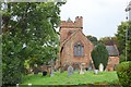
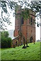
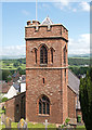
From Kirkoswald, travelling on the B6413 over the Eden Bridge into Lazonby, the church looms on a steep hill on the right hand side of the road and looks very Victorian (the church guide says the foundation stone was laid in 1864, and that "three places of Christian worship have been on this site. Before the Normans came to Cumbria a preaching-cross faced across the River Eden towards the Pennines").
It was hard to spot the cross shaft at first at it lies in the shadow of a tall tree and is the same red colour as the sandstone of the south wall of the church against which it sits near.
There are no discernable markings or carvings on it. The views over the River Eden and the Pennines beyond are impressive.
If you are passing by and are interested in Anglo Saxon crosses, it is worth stopping off for a few minutes to appreciate this ancient spot.
nicoladidsbury have visited here
")
Ancient Cross - supposed to date to 8th Centuary.
See web page written 1901 for evidence
The Cross stands in the churchyard of St Nicholas Church at Lazonby.
You may be viewing yesterday's version of this page. To see the most up to date information please register for a free account.
")
")
Do not use the above information on other web sites or publications without permission of the contributor.
Nearby Images from Geograph Britain and Ireland:
©2007(licence)
©2008(licence)
©2008(licence)
©2017(licence)
©2011(licence)
The above images may not be of the site on this page, they are loaded from Geograph.
Please Submit an Image of this site or go out and take one for us!
Click here to see more info for this site
Nearby sites
Key: Red: member's photo, Blue: 3rd party photo, Yellow: other image, Green: no photo - please go there and take one, Grey: site destroyed
Download sites to:
KML (Google Earth)
GPX (GPS waypoints)
CSV (Garmin/Navman)
CSV (Excel)
To unlock full downloads you need to sign up as a Contributory Member. Otherwise downloads are limited to 50 sites.
Turn off the page maps and other distractions
Nearby sites listing. In the following links * = Image available
1.3km NNE 29° St Oswald's Well (Kirkoswald)* Holy Well or Sacred Spring (NY55524090)
1.5km ESE 110° St Michael's Holy Well (Lazonby) Holy Well or Sacred Spring (NY5627039260)
2.4km E 100° Glassonby* Stone Circle (NY57283935)
2.9km ESE 120° Addingham Cross* Ancient Cross (NY57443829)
3.1km SSE 147° Hunsonby Cursus Cursus (NY56543719)
3.4km SE 139° Long Meg And Her Daughters* Stone Circle (NY57113721)
3.4km SE 140° Long Meg* Standing Stone (Menhir) (NY57063716)
3.6km SE 129° Little Meg* Stone Circle (NY5769037479)
3.7km NNW 341° Chapel Well (Staffield)* Holy Well or Sacred Spring (NY53744326)
3.8km NNW 338° Cross House Incised Stone* Ancient Cross (NY5350843277)
6.6km WSW 249° Hallrigg Standing Stone* Standing Stone (Menhir) (NY4865737482)
6.7km N 359° Broomrigg C* Stone Circle (NY548465)
6.8km N 358° Broomrigg I Standing Stone* Standing Stone (Menhir) (NY54784654)
6.8km N 359° Broomrigg B1* Stone Circle (NY54844659)
6.8km N 0° Broomrigg D* Stone Circle (NY550466)
6.9km N 359° Broomrigg Multiple Stone Rows* Multiple Stone Rows / Avenue (NY548467)
7.0km N 358° Broomrigg A* Stone Row / Alignment (NY5473346779)
7.5km SW 224° Lowhouse* Stone Circle (NY49623435)
7.8km SSE 165° Edenhall Cross (Langwathby)* Ancient Cross (NY5676732230)
7.8km SSE 168° St Cuthbert's Well (Edenhall Park)* Holy Well or Sacred Spring (NY564321)
8.0km SSE 165° St. Cuthbert's Church (Edenhall)* Ancient Cross (NY5689832046)
8.0km NNE 18° Spearhead Mould Find Site Ancient Mine, Quarry or other Industry (NY574474)
8.9km N 357° Grey Yauds* Stone Circle (NY5448748668)
8.9km N 357° Grey Yauds Multiple Stone Rows / Avenue (NY545487)
9.3km S 191° Dickey Bank Holy Well (Carleton Hill) Holy Well or Sacred Spring (NY5309030660)
View more nearby sites and additional images


 We would like to know more about this location. Please feel free to add a brief description and any relevant information in your own language.
 Wir möchten mehr über diese Stätte erfahren. Bitte zögern Sie nicht, eine kurze Beschreibung und relevante Informationen in Deutsch hinzuzufügen.
 Nous aimerions en savoir encore un peu sur les lieux. S'il vous plaît n'hesitez pas à ajouter une courte description et tous les renseignements pertinents dans votre propre langue.
 Quisieramos informarnos un poco más de las lugares. No dude en añadir una breve descripción y otros datos relevantes en su propio idioma.