


<< Our Photo Pages >> The Lawley (Summit) - Hillfort in England in Shropshire
Submitted by TheWhiteRider on Monday, 12 June 2006 Page Views: 12430
Iron Age and Later PrehistorySite Name: The Lawley (Summit)Country: England
NOTE: This site is 0.494 km away from the location you searched for.
County: Shropshire Type: Hillfort
Nearest Town: Church Stretton Nearest Village: Enchmarsh
Map Ref: SO49459745
Latitude: 52.572509N Longitude: 2.747306W
Condition:
| 5 | Perfect |
| 4 | Almost Perfect |
| 3 | Reasonable but with some damage |
| 2 | Ruined but still recognisable as an ancient site |
| 1 | Pretty much destroyed, possibly visible as crop marks |
| 0 | No data. |
| -1 | Completely destroyed |
| 5 | Superb |
| 4 | Good |
| 3 | Ordinary |
| 2 | Not Good |
| 1 | Awful |
| 0 | No data. |
| 5 | Can be driven to, probably with disabled access |
| 4 | Short walk on a footpath |
| 3 | Requiring a bit more of a walk |
| 2 | A long walk |
| 1 | In the middle of nowhere, a nightmare to find |
| 0 | No data. |
| 5 | co-ordinates taken by GPS or official recorded co-ordinates |
| 4 | co-ordinates scaled from a detailed map |
| 3 | co-ordinates scaled from a bad map |
| 2 | co-ordinates of the nearest village |
| 1 | co-ordinates of the nearest town |
| 0 | no data |
Internal Links:
External Links:
I have visited· I would like to visit
TheWhiteRider Serenstar have visited here
 (PID:21325)")
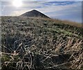
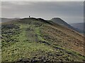
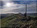
It is clearly visible. The rest of the feature, including scarp banks running back towards the summit and a hut platform at the summit are almost impossible to discern, but there are faint features that seem to confirm their existence.
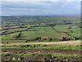
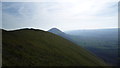
Magnificent views make the arduous climb from the Southern end of the hill worthwhile.
Lawley appears to come from old English and means Lafa's-leah, Lafa being a personal name.
Towards the Northern end of the hill there is another hillfort/enclosure. (See separate post)
You may be viewing yesterday's version of this page. To see the most up to date information please register for a free account.
 (PID:21328)")
 (PID:21327)")
 (PID:21326)")
Do not use the above information on other web sites or publications without permission of the contributor.
Nearby Images from Geograph Britain and Ireland:
©2022(licence)
©2022(licence)
©2015(licence)
©2022(licence)
©2022(licence)
The above images may not be of the site on this page, they are loaded from Geograph.
Please Submit an Image of this site or go out and take one for us!
Click here to see more info for this site
Nearby sites
Key: Red: member's photo, Blue: 3rd party photo, Yellow: other image, Green: no photo - please go there and take one, Grey: site destroyed
Download sites to:
KML (Google Earth)
GPX (GPS waypoints)
CSV (Garmin/Navman)
CSV (Excel)
To unlock full downloads you need to sign up as a Contributory Member. Otherwise downloads are limited to 50 sites.
Turn off the page maps and other distractions
Nearby sites listing. In the following links * = Image available
1.4km NE 34° The Lawley (Northern)* Hillfort (SO50289863)
2.6km SSW 212° Caer Caradoc Round Barrow* Round Barrow(s) (SO48059529)
2.8km SW 218° Caer Caradoc (Church Stretton)* Hillfort (SO477953)
3.7km WSW 245° Castle Hill (Shropshire)* Hillfort (SO461959)
3.9km SSW 205° Hope Bowdler Hill* Cairn (SO47779389)
5.2km NE 48° The Frog Well Holy Well or Sacred Spring (SJ53340084)
5.2km W 261° High Park Cross Dyke* Ancient Village or Settlement (SO443967)
5.6km SW 228° Stretton Sheela* Early Christian Sculptured Stone (SO45239368)
5.6km WSW 240° Bodbury Ring* Hillfort (SO445947)
6.3km WSW 239° The Devil's Mouth Cross Dyke* Misc. Earthwork (SO43959425)
6.5km W 261° Robin Hood's Butts (Shropshire)* Round Barrow(s) (SO43029655)
6.7km W 264° Henley Knap Bowl Barrow* Round Barrow(s) (SO42799685)
6.9km SW 231° Ashlet Hill Bowl Barrow Round Barrow(s) (SO440932)
7.1km W 263° Wildmoor Bowl Barrow* Round Barrow(s) (SO42409672)
7.4km WSW 254° Long Mynd C* Round Barrow(s) (SO423955)
7.4km WSW 246° Long Mynd A* Round Barrow(s) (SO426945)
7.5km ESE 115° Mogg Forest Hillfort* Hillfort (SO5621194262)
7.6km WSW 254° Shooting Box Disc Barrow* Round Barrow(s) (SO421954)
7.7km WSW 248° Boiling Well (Long Mynd)* Round Barrow(s) (SO423946)
8.2km SW 232° Cross Dyke Bowl Barrow North* Round Barrow(s) (SO42899244)
8.3km SW 232° Cross Dyke Bowl Barrow South* Round Barrow(s) (SO42869241)
8.3km W 274° Ratlinghope Hill Bowl Barrow* Round Barrow(s) (SO41179817)
8.3km SW 235° Barrister's Plain Cross Dyke* Ancient Village or Settlement (SO426927)
8.7km NE 44° Stevenshill* Hillfort (SJ556036)
8.7km W 268° Ratlinghope Hill Camp* Hillfort (SO407973)
View more nearby sites and additional images


 We would like to know more about this location. Please feel free to add a brief description and any relevant information in your own language.
 Wir möchten mehr über diese Stätte erfahren. Bitte zögern Sie nicht, eine kurze Beschreibung und relevante Informationen in Deutsch hinzuzufügen.
 Nous aimerions en savoir encore un peu sur les lieux. S'il vous plaît n'hesitez pas à ajouter une courte description et tous les renseignements pertinents dans votre propre langue.
 Quisieramos informarnos un poco más de las lugares. No dude en añadir una breve descripción y otros datos relevantes en su propio idioma.