


<< Our Photo Pages >> Cavers Cross - Ancient Cross in Scotland in Scottish Borders
Submitted by Anne T on Friday, 31 August 2018 Page Views: 1859
Early Medieval (Dark Age)Site Name: Cavers Cross Alternative Name: Cavers Auld KirkCountry: Scotland
NOTE: This site is 0.404 km away from the location you searched for.
County: Scottish Borders Type: Ancient Cross
Nearest Town: Hawick Nearest Village: Cavers
Map Ref: NT54071564
Latitude: 55.432485N Longitude: 2.727375W
Condition:
| 5 | Perfect |
| 4 | Almost Perfect |
| 3 | Reasonable but with some damage |
| 2 | Ruined but still recognisable as an ancient site |
| 1 | Pretty much destroyed, possibly visible as crop marks |
| 0 | No data. |
| -1 | Completely destroyed |
| 5 | Superb |
| 4 | Good |
| 3 | Ordinary |
| 2 | Not Good |
| 1 | Awful |
| 0 | No data. |
| 5 | Can be driven to, probably with disabled access |
| 4 | Short walk on a footpath |
| 3 | Requiring a bit more of a walk |
| 2 | A long walk |
| 1 | In the middle of nowhere, a nightmare to find |
| 0 | No data. |
| 5 | co-ordinates taken by GPS or official recorded co-ordinates |
| 4 | co-ordinates scaled from a detailed map |
| 3 | co-ordinates scaled from a bad map |
| 2 | co-ordinates of the nearest village |
| 1 | co-ordinates of the nearest town |
| 0 | no data |
Internal Links:
External Links:
I have visited· I would like to visit
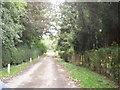
Anne T visited on 29th Aug 2018 - their rating: Cond: 2 Amb: 4 Access: 5 Cavers Cross, near Hawick: From the motte, we drove round to Cavers – a very nicely kept estate, with well kept verges and few places to park along the straight, narrow road by the houses. In the end, we pulled right up to the fence at the largish entrance to a field gate at NT 54235 15805, intending to run back to the car if anyone thought we were in the way.
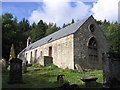
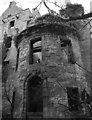
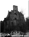
Walking south west towards the houses (I didn’t even recognise the Auld Kirk, as its been converted into a house with large driveway), we couldn’t see anything resembling a cross. There was a lady who was painting her fence and her large dog, who barked at us and sniffed my hands. I asked her if she knew of the remains of the cross, and she said, “Yes, but it’s only small”. She showed us where it was ‘hiding’ – behind a fence and shrubs in deep shade, then behind its own wooden fence, now much broken. She gave us permission to go into the garden of the holiday cottage as there was no-one there at the time of our visit. Whilst the Canmore record mentions the base of the cross (with the metal bands much visible), nothing is mentioned about the shaft it currently holds. This is of red sandstone and shaped, although much moss-covered.
Moving a small bit of stone near the join of the shaft and the base, there is evidence of a straight cut for part of the socket hole. We didn’t’ see any dowel holes, as the surface was moss and twig covered, but then the report that mentions this is dated 1933!
")
The remains of this early medieval cross can be found near the Auld Kirk in the hamlet of Cavers, near Hawick. Recorded as Canmore ID 55297. Their latest entry was made in 1956, based on a visit from 1933, and tells us: "All that is left of this cross is the moulded base which lies in pieces, held together by a metal band …. less than 100 yards NNE or the church … the base is circular, measuring about 2 ft. 1 1/2 in. in diameter by 1 ft. 2 in. high, and it has evidently supported a column about 12 in. in diameter. On its upper surface there are four dowel-holes."
The cross can be viewed from the entrance to the driveway to the Auld Kirk (now a private house), and is well hidden in the shrubbery of the neighbouring holiday cottage, and has its own, now disintegrated fence to protect it from damage.
We were very kindly given permission by the owner to walk into the garden of the holiday cottage for a closer look.
You may be viewing yesterday's version of this page. To see the most up to date information please register for a free account.
")
")
")
")
Do not use the above information on other web sites or publications without permission of the contributor.
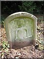
Nearby Images from Geograph Britain and Ireland:
©2010(licence)
©2006(licence)
©2006(licence)
©2015(licence)
©2015(licence)
The above images may not be of the site on this page, they are loaded from Geograph.
Please Submit an Image of this site or go out and take one for us!
Click here to see more info for this site
Nearby sites
Key: Red: member's photo, Blue: 3rd party photo, Yellow: other image, Green: no photo - please go there and take one, Grey: site destroyed
Download sites to:
KML (Google Earth)
GPX (GPS waypoints)
CSV (Garmin/Navman)
CSV (Excel)
To unlock full downloads you need to sign up as a Contributory Member. Otherwise downloads are limited to 50 sites.
Turn off the page maps and other distractions
Nearby sites listing. In the following links * = Image available
2.2km NNW 339° Midshiels Cairn* Cairn (NT53311770)
2.2km NNW 341° Midshiels Standing Stone* Standing Stone (Menhir) (NT53391774)
3.9km E 90° Rubers Law* Hillfort (NT58031557)
4.4km WSW 249° Hawick Mote* Misc. Earthwork (NT4994314073)
4.5km SE 142° Hawthornside Farm (Bonchester Bridge)* Holy Well or Sacred Spring (NT5678612089)
5.9km ENE 66° Bedrule Sculptured Stone (NT59501793)
6.0km ENE 64° Fast Castle (Bedrule)* Misc. Earthwork (NT59531822)
6.3km ENE 68° Bedrule Parish Church* Sculptured Stone (NT5992217925)
7.9km S 183° Stonedge Stone Circle (NT536077)
8.5km SW 224° Lord's Tree (Hawick)* Cairn (NT48090957)
9.0km SW 222° Ca Knowe (Hawick)* Cairn (NT4793409075)
9.7km E 84° Gilliestongues Promontory Fort / Cliff Castle (NT63721659)
10.4km W 261° Borthwick Mains Class I Pictish Symbol Stone (NT4372814111)
10.4km WSW 252° Whitcastle Hill* Hillfort (NT44101245)
10.6km WSW 250° Whitcastle Sike* Ancient Village or Settlement (NT44011207)
11.3km ESE 123° Southdean Law* Hillfort (NT63500938)
11.7km SW 216° Burgh Hill Stone Circle* Stone Circle (NT47010624)
11.8km SW 215° The Dod* Ancient Village or Settlement (NT47260600)
11.9km SW 217° Burgh Hill Hillfort* Hillfort (NT46810616)
11.9km ENE 66° Jedburgh Ancient Christian Stones* Ancient Cross (NT65052038)
12.0km ENE 66° Jedburgh Rock Art Rock Art (NT651204)
12.3km NE 40° Ancrum Old Church* Sculptured Stone (NT6215024885)
12.4km NE 41° Castle Hill (Ancrum)* Hillfort (NT6239424909)
13.0km NE 49° Harestanes (Ancrum) Stone Circle (NT640240)
13.0km NE 50° Harestanes (Ancrum) Stone Circle (NT641240)
View more nearby sites and additional images


 We would like to know more about this location. Please feel free to add a brief description and any relevant information in your own language.
 Wir möchten mehr über diese Stätte erfahren. Bitte zögern Sie nicht, eine kurze Beschreibung und relevante Informationen in Deutsch hinzuzufügen.
 Nous aimerions en savoir encore un peu sur les lieux. S'il vous plaît n'hesitez pas à ajouter une courte description et tous les renseignements pertinents dans votre propre langue.
 Quisieramos informarnos un poco más de las lugares. No dude en añadir una breve descripción y otros datos relevantes en su propio idioma.