 with our Megalithic Portal iPhone app")


<< Our Photo Pages >> St Joseph's Well - Holy Well or Sacred Spring in England in Somerset
Submitted by JimChampion on Monday, 29 March 2004 Page Views: 12522
Springs and Holy WellsSite Name: St Joseph's WellCountry: England
NOTE: This site is 0.272 km away from the location you searched for.
County: Somerset Type: Holy Well or Sacred Spring
Nearest Town: Glastonbury
Map Ref: ST49993883 Landranger Map Number: 182
Latitude: 51.146536N Longitude: 2.716319W
Condition:
| 5 | Perfect |
| 4 | Almost Perfect |
| 3 | Reasonable but with some damage |
| 2 | Ruined but still recognisable as an ancient site |
| 1 | Pretty much destroyed, possibly visible as crop marks |
| 0 | No data. |
| -1 | Completely destroyed |
| 5 | Superb |
| 4 | Good |
| 3 | Ordinary |
| 2 | Not Good |
| 1 | Awful |
| 0 | No data. |
| 5 | Can be driven to, probably with disabled access |
| 4 | Short walk on a footpath |
| 3 | Requiring a bit more of a walk |
| 2 | A long walk |
| 1 | In the middle of nowhere, a nightmare to find |
| 0 | No data. |
| 5 | co-ordinates taken by GPS or official recorded co-ordinates |
| 4 | co-ordinates scaled from a detailed map |
| 3 | co-ordinates scaled from a bad map |
| 2 | co-ordinates of the nearest village |
| 1 | co-ordinates of the nearest town |
| 0 | no data |
Internal Links:
External Links:
I have visited· I would like to visit
hallsifer would like to visit
Ogham visited on 11th Jan 0009 - their rating: Cond: 3 Amb: 4 Access: 4
JimChampion have visited here
")
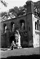
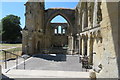
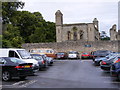
This wellhead was uncovered in 1825 when the crypt beneath the ruined Lady Chapel - also known as St Joseph's Chapel - was being cleared. St Joseph (of Arimathea) was the legendary founder of the first church on this site when he journeyed to Britain in the first century AD bearing the Holy Grail.
The arch over the recess that houses the wellhead is of Norman style, and is believed to have been relocated from a no longer needed window of the Lady Chapel when it was extended to the east in the 13th century. A closer examination of the well shaft in 1991/92 showed that it was similar to other Roman wells excavated in the region, supporting the idea that the well is of early date. Perhaps its presence was a reason for siting the original church next to this spot?
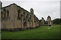
Access St Joseph's well is in the crypt of the Lady Chapel within the precinct of Glastonbury Abbey. The ruins are open to the public (see the Official Glastonbury Abbey website for opening times and admission charges), but direct access to the well is prevented by a locked grill gate.
You may be viewing yesterday's version of this page. To see the most up to date information please register for a free account.
")
")
")
Do not use the above information on other web sites or publications without permission of the contributor.
Nearby Images from Geograph Britain and Ireland:
©2011(licence)
©2015(licence)
©2018(licence)
©2018(licence)
©2012(licence)
The above images may not be of the site on this page, they are loaded from Geograph.
Please Submit an Image of this site or go out and take one for us!
Click here to see more info for this site
Nearby sites
Key: Red: member's photo, Blue: 3rd party photo, Yellow: other image, Green: no photo - please go there and take one, Grey: site destroyed
Download sites to:
KML (Google Earth)
GPX (GPS waypoints)
CSV (Garmin/Navman)
CSV (Excel)
To unlock full downloads you need to sign up as a Contributory Member. Otherwise downloads are limited to 50 sites.
Turn off the page maps and other distractions
Nearby sites listing. In the following links * = Image available
114m NW 307° Glastonbury Lake Village Museum* Museum (ST499389)
148m NW 309° Market Cross (Glastonbury) Ancient Cross (ST4987538924)
170m SE 139° Omphalos Stone (Glastonbury Abbey)* Natural Stone / Erratic / Other Natural Feature (ST501387)
781m ESE 114° Chalice Well* Holy Well or Sacred Spring (ST507385)
808m ESE 113° White Spring (Somerset)* Holy Well or Sacred Spring (ST5073238506)
1.2km E 100° Glastonbury Tor* Ancient Village or Settlement (ST51223861)
2.0km NNW 339° Glastonbury Lake Village* Ancient Village or Settlement (ST493407)
3.5km ESE 108° Ponter's Ball Dyke Ancient Village or Settlement (ST533377)
5.1km NE 34° Harters Hill* Ancient Trackway (ST529430)
5.6km S 175° New Ditch* Ancient Village or Settlement (ST504332)
6.2km WNW 301° Meare Lake Village Ancient Village or Settlement (ST4472642100)
6.8km SSW 193° Dundon Hill* Hillfort (ST484322)
7.1km SSW 192° Dundon Beacon Barrow* Round Barrow(s) (ST485319)
7.7km WNW 293° Peat Moors Centre* Museum (ST429419)
7.8km WNW 288° Avalon Marshes Visitor Centre* Museum (ST426413)
7.8km WNW 284° Sweet Track* Ancient Trackway (ST424408)
8.5km NE 37° Glastonbury Tor milestone at Wells* Modern Stone Circle etc (ST552456)
8.7km NE 36° Wells Cathedral* Early Christian Sculptured Stone (ST5514645865)
8.7km NE 35° Wells and Mendip Museum* Museum (ST551459)
8.7km NE 36° St Andrew's Well (Wells)* Holy Well or Sacred Spring (ST5522745824)
8.9km WNW 294° Abbot's Way* Ancient Trackway (ST419425)
9.1km E 91° Glastonbury Stone Circle* Modern Stone Circle etc (ST59143858)
9.4km NNE 19° Wookey Hole Caves Museum* Museum (ST531477)
9.6km NE 45° King's Castle (Wells) Ancient Village or Settlement (ST568456)
9.7km NNE 19° Badger Hole (Somerset) Cave or Rock Shelter (ST53244795)
View more nearby sites and additional images


 We would like to know more about this location. Please feel free to add a brief description and any relevant information in your own language.
 Wir möchten mehr über diese Stätte erfahren. Bitte zögern Sie nicht, eine kurze Beschreibung und relevante Informationen in Deutsch hinzuzufügen.
 Nous aimerions en savoir encore un peu sur les lieux. S'il vous plaît n'hesitez pas à ajouter une courte description et tous les renseignements pertinents dans votre propre langue.
 Quisieramos informarnos un poco más de las lugares. No dude en añadir una breve descripción y otros datos relevantes en su propio idioma.