


<< Our Photo Pages >> St. Brandan's Stanes - Stone Circle in Scotland in Aberdeenshire
Submitted by Anonymous on Monday, 15 July 2002 Page Views: 8394
Neolithic and Bronze AgeSite Name: St. Brandan's Stanes Alternative Name: Templeton FarmCountry: Scotland
NOTE: This site is 3.286 km away from the location you searched for.
County: Aberdeenshire Type: Stone Circle
Nearest Town: Banff Nearest Village: Cornhill
Map Ref: NJ60756105 Landranger Map Number: 29
Latitude: 57.637668N Longitude: 2.659046W
Condition:
| 5 | Perfect |
| 4 | Almost Perfect |
| 3 | Reasonable but with some damage |
| 2 | Ruined but still recognisable as an ancient site |
| 1 | Pretty much destroyed, possibly visible as crop marks |
| 0 | No data. |
| -1 | Completely destroyed |
| 5 | Superb |
| 4 | Good |
| 3 | Ordinary |
| 2 | Not Good |
| 1 | Awful |
| 0 | No data. |
| 5 | Can be driven to, probably with disabled access |
| 4 | Short walk on a footpath |
| 3 | Requiring a bit more of a walk |
| 2 | A long walk |
| 1 | In the middle of nowhere, a nightmare to find |
| 0 | No data. |
| 5 | co-ordinates taken by GPS or official recorded co-ordinates |
| 4 | co-ordinates scaled from a detailed map |
| 3 | co-ordinates scaled from a bad map |
| 2 | co-ordinates of the nearest village |
| 1 | co-ordinates of the nearest town |
| 0 | no data |
Internal Links:
External Links:
")
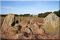
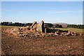
St Brandan's Stones are recorded as Canmore ID 18495, the 1906 entry of which reads: "St Brandan's Stanes. The few stones remaining of this stone circle are situated on the farm of Templeton, at the south extremity of a long strip of fir plantation running down from Bankhead Farm. The ground plan shows two pillars with, between them, a recumbent stone 8 feet long. In front of the pillars lie four large blocks and, close to the east face of the east pillar, an almost square block, vertical and apparently earth fast. This may be the beginning of an inner stone-setting. The east pillar shows signs of having been split and part-removed, in modern times. The west pillar has eight cupmarks near its base. In or before 1866 there were twelve, but some may have been obscured by the growth of grass and weeds around the base."
A 2005 field visit records: "These two upright stones are probably the remains of a recumbent stone circle occupying a slight terrace on the gentle NNE facing slope dropping down above Templeton. The two stones stand some 2m apart and are probably the flankers of the recumbent setting, though the recumbent itself has been removed. Nevertheless, the placing of the stones (1 & 3), with their more regular sides facing SSW and sloping back towards the NNE, indicates that the setting stood on the SSW arc of the circle. The W flanker (1), which at 1.7m in height is some 0.25m shorter than its neighbour, exhibits six large cupmarks upon the lower part of its rear face; six others are concealed by the field clearance gathered around its foot (see below). An earthfast stone (C) 0.85m high set immediately behind the E flanker is probably the sole surviving kerbstone of a cairn within the circle; a thin veneer of cairn material survives immediately to the rear of the setting and presumably extends beneath the field-gathered stones piled around the two flankers, but the rest has been cleared in the course of cultivation. At least one of the stones (A) on this heap is probably a displaced orthostat, and it is possible that a smaller stone (B) is yet another."
You may be viewing yesterday's version of this page. To see the most up to date information please register for a free account.
")
")
")
Do not use the above information on other web sites or publications without permission of the contributor.
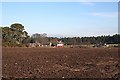
Nearby Images from Geograph Britain and Ireland:
©2008(licence)
©2008(licence)
©2008(licence)
©2008(licence)
©2008(licence)
The above images may not be of the site on this page, they are loaded from Geograph.
Please Submit an Image of this site or go out and take one for us!
Click here to see more info for this site
Nearby sites
Key: Red: member's photo, Blue: 3rd party photo, Yellow: other image, Green: no photo - please go there and take one, Grey: site destroyed
Download sites to:
KML (Google Earth)
GPX (GPS waypoints)
CSV (Garmin/Navman)
CSV (Excel)
To unlock full downloads you need to sign up as a Contributory Member. Otherwise downloads are limited to 50 sites.
Turn off the page maps and other distractions
Nearby sites listing. In the following links * = Image available
4.9km NNW 340° St Comb's Well (Portsoy)* Holy Well or Sacred Spring (NJ591657)
6.0km E 93° St Colme's Well* Holy Well or Sacred Spring (NJ668607)
6.6km E 97° Stirling Cairn* Cairn (NJ67296015)
6.6km SSW 202° Thorax* Stone Circle (NJ58225495)
6.6km NW 314° Sandend Bay B Cairn (NJ56016571)
6.6km NW 314° Sandend Bay A Stone Circle (NJ560657)
7.5km ENE 71° Lusy Law* Cairn (NJ67866346)
7.8km WNW 291° Gaul Cross* Stone Circle (NJ53506387)
8.8km ENE 77° Gavenie Braes* Stone Circle (NJ69386293)
9.2km SE 131° North Burreldales* Stone Circle (NJ6759054916)
9.4km SE 129° Newton Of Montblairy Stone Circle (NJ680550)
10.0km S 183° The White Stone, Whitemuir Farm Natural Stone / Erratic / Other Natural Feature (NJ60125110)
10.6km S 181° Bellman's Wood* Stone Circle (NJ6047150429)
10.7km ESE 107° King Edward Class I Pictish Symbol Stone (NJ70925776)
10.9km S 185° Marnoch Church* Stone Circle (NJ5970250206)
11.5km SE 125° Boghead Souterrain Souterrain (Fogou, Earth House) (NJ701543)
12.7km SE 146° Whitehill Wood* Stone Circle (NJ6781750510)
12.7km SE 146° Cairn Ennit* Stone Circle (NJ678504)
13.0km E 85° Longmanhill Cairn Long Barrow (NJ73726200)
13.1km SE 133° Haughs of Ashogle Ancient Village or Settlement (NJ703521)
13.3km WNW 302° Jenny's Well* Holy Well or Sacred Spring (NJ495682)
13.6km SSW 204° Rothiemay* Stone Circle (NJ55084872)
14.2km E 98° Law of Balgreen* Cairn (NJ74815887)
14.4km E 82° Cairn Lee* Cairn (NJ75136284)
14.7km SE 137° Boat of Muiresk Ancient Village or Settlement (NJ707502)
View more nearby sites and additional images


 We would like to know more about this location. Please feel free to add a brief description and any relevant information in your own language.
 Wir möchten mehr über diese Stätte erfahren. Bitte zögern Sie nicht, eine kurze Beschreibung und relevante Informationen in Deutsch hinzuzufügen.
 Nous aimerions en savoir encore un peu sur les lieux. S'il vous plaît n'hesitez pas à ajouter une courte description et tous les renseignements pertinents dans votre propre langue.
 Quisieramos informarnos un poco más de las lugares. No dude en añadir una breve descripción y otros datos relevantes en su propio idioma.