 with our Megalithic Portal iPhone app")


<< Our Photo Pages >> Fast Castle (Bedrule) - Misc. Earthwork in Scotland in Scottish Borders
Submitted by Anne T on Friday, 31 August 2018 Page Views: 1686
Multi-periodSite Name: Fast Castle (Bedrule) Alternative Name: Bedrule Motte; Castle Knowe (Bedrule); Rule WaterCountry: Scotland
NOTE: This site is 3.613 km away from the location you searched for.
County: Scottish Borders Type: Misc. Earthwork
Nearest Town: Hawick Nearest Village: Bedrule
Map Ref: NT59531822
Latitude: 55.456149N Longitude: 2.641475W
Condition:
| 5 | Perfect |
| 4 | Almost Perfect |
| 3 | Reasonable but with some damage |
| 2 | Ruined but still recognisable as an ancient site |
| 1 | Pretty much destroyed, possibly visible as crop marks |
| 0 | No data. |
| -1 | Completely destroyed |
| 5 | Superb |
| 4 | Good |
| 3 | Ordinary |
| 2 | Not Good |
| 1 | Awful |
| 0 | No data. |
| 5 | Can be driven to, probably with disabled access |
| 4 | Short walk on a footpath |
| 3 | Requiring a bit more of a walk |
| 2 | A long walk |
| 1 | In the middle of nowhere, a nightmare to find |
| 0 | No data. |
| 5 | co-ordinates taken by GPS or official recorded co-ordinates |
| 4 | co-ordinates scaled from a detailed map |
| 3 | co-ordinates scaled from a bad map |
| 2 | co-ordinates of the nearest village |
| 1 | co-ordinates of the nearest town |
| 0 | no data |
Internal Links:
External Links:
I have visited· I would like to visit
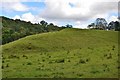
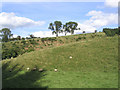
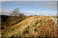
Anne T visited on 29th Aug 2018 - their rating: Cond: 2 Amb: 4 Access: 4 Fast Castle/Bedrule Motte: Not far from Bedrule Church this motte is marked on the map. At first it just appeared as a mound behind some trees, and we weren’t going to stop, until we realised the tree cover finished and the motte was clearly visible from the track going to Bedrule Mill. We let ourselves in through the gate and stopped to photograph this impressive mound. It sits by a bend in the very pretty river Rule.
 (PID:185408)")
This large earthwork can be found in a bend of Rule Water. Recorded as Canmore ID 55206, this site is described as being 700 yards west of the hamlet of Bedrule, above an old ford across the river, and "ha(ving) all the appearance of a 12th century motte. "The mound itself is partly natural, and in its total height of 45 ft. only the upper part, 10 ft. from the summit, is artificial. A byroad has been driven through its S end."
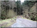
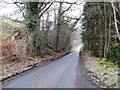
From Bedrule Parish Church, we took the minor road leading north then west towards Jedburgh Road. The site lies just past the site of the old Bedrule Castle (which we couldn't see through the trees). We weren't going to stop until we saw the size of the mound through a clearing in the trees, with a convenient spot to pull up off the road opposite the entrance track to Bedrule Mill.
Walking down the track towards the bridge over the stream (which has been built over the old ford), the mound is in an impressive location, with a terrace between you and the large mound. The earthwork looks as if it has been clipped on its southern side by the building of the road, but is well worth stopping to look at if you've been to see (or on your way to see) the hogback fragments at Bedrule Parish Church.
You may be viewing yesterday's version of this page. To see the most up to date information please register for a free account.
 (PID:185409)")
Do not use the above information on other web sites or publications without permission of the contributor.
Nearby Images from Geograph Britain and Ireland:
©2017(licence)
©2009(licence)
©2009(licence)
©2006(licence)
©2010(licence)
The above images may not be of the site on this page, they are loaded from Geograph.
Please Submit an Image of this site or go out and take one for us!
Click here to see more info for this site
Nearby sites
Key: Red: member's photo, Blue: 3rd party photo, Yellow: other image, Green: no photo - please go there and take one, Grey: site destroyed
Download sites to:
KML (Google Earth)
GPX (GPS waypoints)
CSV (Garmin/Navman)
CSV (Excel)
To unlock full downloads you need to sign up as a Contributory Member. Otherwise downloads are limited to 50 sites.
Turn off the page maps and other distractions
Nearby sites listing. In the following links * = Image available
291m S 185° Bedrule Sculptured Stone (NT59501793)
489m SE 126° Bedrule Parish Church* Sculptured Stone (NT5992217925)
3.0km SSW 209° Rubers Law* Hillfort (NT58031557)
4.5km ESE 111° Gilliestongues Promontory Fort / Cliff Castle (NT63721659)
5.9km ENE 68° Jedburgh Ancient Christian Stones* Ancient Cross (NT65052038)
6.0km ENE 68° Jedburgh Rock Art Rock Art (NT651204)
6.0km WSW 244° Cavers Cross* Ancient Cross (NT54071564)
6.1km W 265° Midshiels Standing Stone* Standing Stone (Menhir) (NT53391774)
6.2km W 265° Midshiels Cairn* Cairn (NT53311770)
6.7km SSW 204° Hawthornside Farm (Bonchester Bridge)* Holy Well or Sacred Spring (NT5678612089)
7.2km NNE 21° Ancrum Old Church* Sculptured Stone (NT6215024885)
7.3km NNE 23° Castle Hill (Ancrum)* Hillfort (NT6239424909)
7.3km NE 37° Harestanes (Ancrum) Stone Circle (NT640240)
7.4km NE 38° Harestanes (Ancrum) Stone Circle (NT641240)
8.6km NE 35° Woodside (Crailing) Standing Stone (Menhir) (NT64552517)
8.7km NNE 26° Harrietsfield Standing Stone (Menhir) (NT63442599)
9.7km SSE 155° Southdean Law* Hillfort (NT63500938)
10.2km SE 124° Edgerston Hillfort (NT67981245)
10.4km WSW 246° Hawick Mote* Misc. Earthwork (NT4994314073)
10.8km NE 45° Nisbet 2 Sculptured Stone (NT67322572)
11.3km NE 55° Crailing Cross* Ancient Cross (NT6879724676)
11.7km SE 138° Shaw Craigs Hillfort (NT67270945)
12.1km SSW 209° Stonedge Stone Circle (NT536077)
12.1km N 8° Maxton Burgh (St Boswells)* Ancient Cross (NT61333020)
12.2km N 5° Hier Well (Benrig)* Holy Well or Sacred Spring (NT60703042)
View more nearby sites and additional images


 We would like to know more about this location. Please feel free to add a brief description and any relevant information in your own language.
 Wir möchten mehr über diese Stätte erfahren. Bitte zögern Sie nicht, eine kurze Beschreibung und relevante Informationen in Deutsch hinzuzufügen.
 Nous aimerions en savoir encore un peu sur les lieux. S'il vous plaît n'hesitez pas à ajouter une courte description et tous les renseignements pertinents dans votre propre langue.
 Quisieramos informarnos un poco más de las lugares. No dude en añadir una breve descripción y otros datos relevantes en su propio idioma.