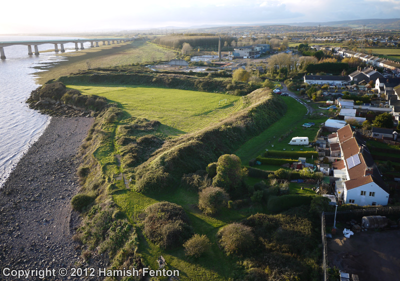
<< Our Photo Pages >> Sudbrook Camp - Hillfort in Wales in Monmouthshire
Submitted by TheCaptain on Thursday, 31 March 2022 Page Views: 13945
Iron Age and Later PrehistorySite Name: Sudbrook CampCountry: Wales County: Monmouthshire Type: Hillfort
Nearest Town: Chepstow Nearest Village: Portskewett
Map Ref: ST50548731 Landranger Map Number: 172
Latitude: 51.582466N Longitude: 2.715217W
Condition:
| 5 | Perfect |
| 4 | Almost Perfect |
| 3 | Reasonable but with some damage |
| 2 | Ruined but still recognisable as an ancient site |
| 1 | Pretty much destroyed, possibly visible as crop marks |
| 0 | No data. |
| -1 | Completely destroyed |
| 5 | Superb |
| 4 | Good |
| 3 | Ordinary |
| 2 | Not Good |
| 1 | Awful |
| 0 | No data. |
| 5 | Can be driven to, probably with disabled access |
| 4 | Short walk on a footpath |
| 3 | Requiring a bit more of a walk |
| 2 | A long walk |
| 1 | In the middle of nowhere, a nightmare to find |
| 0 | No data. |
| 5 | co-ordinates taken by GPS or official recorded co-ordinates |
| 4 | co-ordinates scaled from a detailed map |
| 3 | co-ordinates scaled from a bad map |
| 2 | co-ordinates of the nearest village |
| 1 | co-ordinates of the nearest town |
| 0 | no data |
Internal Links:
External Links:
I have visited· I would like to visit
stevecraig would like to visit
TheCaptain visited on 26th Mar 2022 - their rating: Cond: 3 Amb: 3 Access: 4 Walking the Welsh Coast Path from Chepstow to Caldicot. Remains of iron age fortifications on the banks of the Severn estuary at Sudbrook, beside the railway tunnel pumping station and the landfall of the M4 Severn Crossing on the Welsh side. Lovely looking out to sea when the tide is in, not so lovely looking inland with the houses built so near.
coldrum saw from a distance - their rating: Cond: 2 Amb: 3 Access: 4
Average ratings for this site from all visit loggers: Condition: 2.5 Ambience: 3 Access: 4

This hillfort is recorded as Coflein NPRN 93873 which tells us: "Sudbrook Camp is a defended enclosure situated on the shore of the Bristol Channel at the southern end of the village of Sudbrook. It is defined by up to four lines of ditched ramparts that form a roughly triangular area, about 200m from east-north-east to west-south-west by 92m, resting on a low eroding cliff line on the south". The Coflein entry includes a number of digital images for this defended enclosure.
The Journal of Antiquities also includes an entry for Sudbrook Camp, Portskewett, Monmouthshire, which includes directions for finding this site, together with a photograph, a plan of the camp, a description, details of archaeological finds, and a list of reference sources for more information.
Page originally by Vicky with additions by Anne T.
You may be viewing yesterday's version of this page. To see the most up to date information please register for a free account.


Do not use the above information on other web sites or publications without permission of the contributor.
Click here to see more info for this site
Nearby sites
Key: Red: member's photo, Blue: 3rd party photo, Yellow: other image, Green: no photo - please go there and take one, Grey: site destroyed
Download sites to:
KML (Google Earth)
GPX (GPS waypoints)
CSV (Garmin/Navman)
CSV (Excel)
To unlock full downloads you need to sign up as a Contributory Member. Otherwise downloads are limited to 50 sites.
Turn off the page maps and other distractions
Nearby sites listing. In the following links * = Image available
991m WSW 258° Caldicot Pill Submerged Forest Natural Stone / Erratic / Other Natural Feature (ST4956687114)
1.0km NW 322° Portskewett Chutchyard Cross* Ancient Cross (ST4990088140)
1.3km N 359° Heston Brake* Chambered Tomb (ST50528866)
2.0km WSW 248° Caldicot Castle* Ancient Trackway (ST487866)
3.3km NNW 343° Mathern Round Barrow(s) (ST496905)
3.6km NW 324° Crick Round Barrow* Round Barrow(s) (ST48449025)
4.2km NNE 24° St Tewdric's Well* Holy Well or Sacred Spring (ST5227991167)
4.8km NW 312° Cult Temple at Venta Silurum* Ancient Temple (ST4695890564)
4.8km NW 312° Venta Silurum Settlement* Ancient Village or Settlement (ST46959056)
4.8km NW 310° Silurum Stone Marker Stone (ST46879049)
4.8km N 359° Willis Hill Ancient Village or Settlement (ST50519216)
5.1km ENE 57° St Tecla's Chapel & Holy Well Holy Well or Sacred Spring (ST5484390020)
5.4km W 275° Llanfihangel Rogiet Churchyard Cross* Ancient Cross (ST4512087850)
5.5km NE 37° Thornwell Farm* Chambered Tomb (ST53959167)
5.7km NE 37° Thornwell Round Barrow* Round Barrow(s) (ST540918)
6.0km W 274° Llanfihangel Rogiet* Standing Stone (Menhir) (ST44518775)
6.0km WNW 301° Middle Hendre Round Barrow(s) (ST454905)
6.2km WSW 249° Chapel Tump Ancient Village or Settlement (ST447851)
6.3km NNE 30° The Bulwarks (Monmouthshire)* Hillfort (ST53789274)
6.3km NNE 31° St Peter's Cave Cave or Rock Shelter (ST539927)
6.4km WSW 248° Upton Ancient Trackway Ancient Trackway (ST446850)
6.4km W 269° Undy Earthwork Misc. Earthwork (ST441873)
6.6km WNW 302° Five Lanes Round Barrow (B) Round Barrow(s) (ST45019090)
6.6km WNW 303° Five Lanes Round Barrow (A) Round Barrow(s) (ST45019091)
6.7km WNW 294° Woodcock Hill Barrow Round Barrow(s) (ST44449008)
View more nearby sites and additional images


 We would like to know more about this location. Please feel free to add a brief description and any relevant information in your own language.
 Wir möchten mehr über diese Stätte erfahren. Bitte zögern Sie nicht, eine kurze Beschreibung und relevante Informationen in Deutsch hinzuzufügen.
 Nous aimerions en savoir encore un peu sur les lieux. S'il vous plaît n'hesitez pas à ajouter une courte description et tous les renseignements pertinents dans votre propre langue.
 Quisieramos informarnos un poco más de las lugares. No dude en añadir una breve descripción y otros datos relevantes en su propio idioma.