

, Aubrey Burl")
<< Our Photo Pages >> St John the Evangelist (Gressingham) - Ancient Cross in England in Lancashire
Submitted by TimPrevett on Friday, 18 May 2007 Page Views: 4328
Early Medieval (Dark Age)Site Name: St John the Evangelist (Gressingham)Country: England
NOTE: This site is 2.978 km away from the location you searched for.
County: Lancashire Type: Ancient Cross
Nearest Town: Gressingham
Map Ref: SD5725069915
Latitude: 54.123307N Longitude: 2.655593W
Condition:
| 5 | Perfect |
| 4 | Almost Perfect |
| 3 | Reasonable but with some damage |
| 2 | Ruined but still recognisable as an ancient site |
| 1 | Pretty much destroyed, possibly visible as crop marks |
| 0 | No data. |
| -1 | Completely destroyed |
| 5 | Superb |
| 4 | Good |
| 3 | Ordinary |
| 2 | Not Good |
| 1 | Awful |
| 0 | No data. |
| 5 | Can be driven to, probably with disabled access |
| 4 | Short walk on a footpath |
| 3 | Requiring a bit more of a walk |
| 2 | A long walk |
| 1 | In the middle of nowhere, a nightmare to find |
| 0 | No data. |
| 5 | co-ordinates taken by GPS or official recorded co-ordinates |
| 4 | co-ordinates scaled from a detailed map |
| 3 | co-ordinates scaled from a bad map |
| 2 | co-ordinates of the nearest village |
| 1 | co-ordinates of the nearest town |
| 0 | no data |
Be the first person to rate this site - see the 'Contribute!' box in the right hand menu.
Internal Links:
External Links:
I have visited· I would like to visit
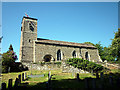
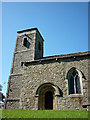
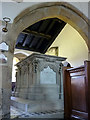
Anne T visited on 4th Jun 2015 - their rating: Cond: 3 Amb: 4 Access: 5 9th Century Anglo Saxon Cross Fragments, St John The Evangelist, Gressingham: Having decided upon a day out in Lancashire/Cumbria on an Anglo Saxon Cross hunt, this was our stop of the day. We approached from junction 35 of the M6, taking the B6254 through Over Kellet and taking a right hand turn, named Fall Kirk, down to Gressingham. This is a pretty little village with the church on the junction of Fall Kirk and Back Lane, sited on a hill next to a small stream which joins the River Lune to the south. Not having phoned through before visiting, we were delighted to find the church open, with a lovely Norman arch over the entrance door on the south wall. But whilst it was warm and sunny outside, this Grade 1 listed church was cold inside.
Whilst the Pastscape and Wikipedia notes talk about more than one fragment of 9th cross inside the church, we could only spot one, despite a thorough hunt by both of us. This was strapped into the north-east corner of the nave, just before a large tomb for George Marton, so I was unable to turn it round to photograph the reverse side. The 9th cross shaft built into the external south-west corner of the nave was easy to spot, with the sunlight picking out the decoration nicely [note: having reviewed the Pastscape notes, another fragment might be inside the vestry, which we didn't check].
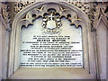
There was a pulpit of dark wood dated 1714 on the south side of the church, and retained some of the original box pews. There was also a tapestry on hessian against the south wall, opposite the chest tomb and the stone fragment which caught my imagination – someone has put a lot of hard work into this.
 (PID:133114)")
Anglo Saxon Cross fragments - some in the church, and one in exterior church wall.
You may be viewing yesterday's version of this page. To see the most up to date information please register for a free account.
 (PID:133119)")
 (PID:133116)")
 (PID:133154)")
Do not use the above information on other web sites or publications without permission of the contributor.
Nearby Images from Geograph Britain and Ireland:
©2011(licence)
©2011(licence)
©2011(licence)
©2011(licence)
©2011(licence)
The above images may not be of the site on this page, they are loaded from Geograph.
Please Submit an Image of this site or go out and take one for us!
Click here to see more info for this site
Nearby sites
Key: Red: member's photo, Blue: 3rd party photo, Yellow: other image, Green: no photo - please go there and take one, Grey: site destroyed
Download sites to:
KML (Google Earth)
GPX (GPS waypoints)
CSV (Garmin/Navman)
CSV (Excel)
To unlock full downloads you need to sign up as a Contributory Member. Otherwise downloads are limited to 50 sites.
Turn off the page maps and other distractions
Nearby sites listing. In the following links * = Image available
971m ESE 102° Castle Stede Hillfort (SD582697)
1.8km SE 137° St Margaret (Hornby)* Ancient Cross (SD5847068580)
2.8km ENE 64° St Wilfrid (Melling)* Ancient Cross (SD5978571115)
4.1km ESE 110° Tatham Enclosure* Ancient Village or Settlement (SD61086846)
5.7km WNW 301° Manor Farm* Round Barrow(s) (SD52387285)
5.7km SSE 150° Roeburndale stone circle* Modern Stone Circle etc (SD60086496)
5.8km NE 45° St John the Baptist (Tunstall)* Early Christian Sculptured Stone (SD6141473925)
7.5km NW 308° Yealand ancient stone walls or rows 1 Misc. Earthwork (SD514746)
8.0km WNW 293° Warton Crag giant wall Misc. Earthwork (SD499731)
8.0km NW 312° Yealand ancient stone walls or rows 2 Misc. Earthwork (SD513753)
8.1km NNE 23° Sellet Bank Enclosure* Ancient Village or Settlement (SD60517733)
8.2km NNW 329° St James's Church (Burton-in-Kendal) Ancient Cross (SD5305076921)
8.2km W 275° Hunting Hill* Round Barrow(s) (SD49037065)
8.3km WNW 301° Summerhouse Hill Cairn* Cairn (SD50147428)
8.4km N 357° Hutton Roof Crag perched Limestone Boulder* Natural Stone / Erratic / Other Natural Feature (SD5686878268)
8.5km WNW 301° Summerhouse Hill* Modern Stone Circle etc (SD50037437)
8.5km SW 233° The Lancaster Cross* Ancient Cross (SD504649)
8.5km WNW 289° Warton Crag* Hillfort (SD492727)
8.5km WNW 294° The Three brothers* Natural Stone / Erratic / Other Natural Feature (SD495735)
8.5km WSW 254° Bolton-le-Sands Barrow* Ring Cairn (SD4901467624)
8.8km SSW 210° Askew Heights* Ancient Village or Settlement (SD52726239)
9.0km SW 234° Halton St Wilfrid's Churchyard* Ancient Cross (SD49916469)
9.0km N 6° Gallowber Lane Romano-British Settlement/Enclosure* Ancient Village or Settlement (SD5823678908)
9.2km WSW 255° Bolton Le Sands Early Christian Sculptured Stone (SD48336765)
9.2km WSW 256° St Michael's Well (Lancashire) Holy Well or Sacred Spring (SD4828567831)
View more nearby sites and additional images


 We would like to know more about this location. Please feel free to add a brief description and any relevant information in your own language.
 Wir möchten mehr über diese Stätte erfahren. Bitte zögern Sie nicht, eine kurze Beschreibung und relevante Informationen in Deutsch hinzuzufügen.
 Nous aimerions en savoir encore un peu sur les lieux. S'il vous plaît n'hesitez pas à ajouter une courte description et tous les renseignements pertinents dans votre propre langue.
 Quisieramos informarnos un poco más de las lugares. No dude en añadir una breve descripción y otros datos relevantes en su propio idioma.