


<< Our Photo Pages >> St Margaret (Hornby) - Ancient Cross in England in Lancashire
Submitted by TimPrevett on Friday, 18 May 2007 Page Views: 4607
Early Medieval (Dark Age)Site Name: St Margaret (Hornby)Country: England
NOTE: This site is 2.975 km away from the location you searched for.
County: Lancashire Type: Ancient Cross
Nearest Town: Hornby
Map Ref: SD5847068580
Latitude: 54.111409N Longitude: 2.636744W
Condition:
| 5 | Perfect |
| 4 | Almost Perfect |
| 3 | Reasonable but with some damage |
| 2 | Ruined but still recognisable as an ancient site |
| 1 | Pretty much destroyed, possibly visible as crop marks |
| 0 | No data. |
| -1 | Completely destroyed |
| 5 | Superb |
| 4 | Good |
| 3 | Ordinary |
| 2 | Not Good |
| 1 | Awful |
| 0 | No data. |
| 5 | Can be driven to, probably with disabled access |
| 4 | Short walk on a footpath |
| 3 | Requiring a bit more of a walk |
| 2 | A long walk |
| 1 | In the middle of nowhere, a nightmare to find |
| 0 | No data. |
| 5 | co-ordinates taken by GPS or official recorded co-ordinates |
| 4 | co-ordinates scaled from a detailed map |
| 3 | co-ordinates scaled from a bad map |
| 2 | co-ordinates of the nearest village |
| 1 | co-ordinates of the nearest town |
| 0 | no data |
Be the first person to rate this site - see the 'Contribute!' box in the right hand menu.
Internal Links:
External Links:
I have visited· I would like to visit
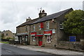
Anne T visited on 4th Jun 2015 - their rating: Cond: 3 Amb: 4 Access: 5 Anglo Saxon Cross Fragments, St. Margaret's Church, Hornby: From Gressingham, we continued east along the twisty-turny Back Lane, over the narrow bridge over the River Lune, to its junction with the A683. Turning right, we were almost immediately in Hornby. St. Margaret’s sits on the left hand side of the road, before the main road takes a right hand turn. There is ample parking on the right hand side of the road opposite the church which is distinctive with its octagonal tower.
Opening the gate from Main Street, you fall into the porch of the church, which is very dark. Inside, the church appears very modern and (to me) without personality, although there is evidence of much older structures such as the traces of old roof lines in the interior west wall; Pastscape records it as having building having started in 1514, with the nave being rebuilt in 1817 with clerestorey being added in 1889.
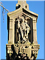
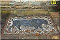
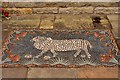
There was no church guide, just one board with an A4 sheet of notes. This told us that: “Under the tower are two fragments of 9th century crosses, one showing the five loaves and two fishes; this is unique in England, though there are two in Ireland. They both came from the Priory ...”, although the Pastscape record says they are 8th to 9th century and that both fragments had been reused in a 19th century barn wall at Priory Farm before coming to the St. Margaret’s. The church notes continued: “The churchyard contains a huge cross base, which may be pre-Conquest or Norman. The original cross could have been twelve feet high. Its presence is something of a mystery.”
The Anglo Saxon Cross Fragment with the carving of the five loaves and two fishes was impressive, and definitely worth stopping to see. Alongside it, to the right, was a much smaller fragment with chevrons.
The churchyard is beautifully kept, with well mown grass and shrubs being clipped into amazing shapes and kept low to the ground. The cross base is huge in comparison to others that I’ve seen – I had to climb on top of a stone to photograph the top, which has a slot for a cross to go into on top.
 (PID:133123)")
Anglo Saxon cross fragment in St Margaret's, Hornby
You may be viewing yesterday's version of this page. To see the most up to date information please register for a free account.
 (PID:133128)")
 (PID:133126)")
 (PID:133124)")
Do not use the above information on other web sites or publications without permission of the contributor.
Nearby Images from Geograph Britain and Ireland:
©2018(licence)
©2018(licence)
©2011(licence)
©2012(licence)
©2012(licence)
The above images may not be of the site on this page, they are loaded from Geograph.
Please Submit an Image of this site or go out and take one for us!
Click here to see more info for this site
Nearby sites
Key: Red: member's photo, Blue: 3rd party photo, Yellow: other image, Green: no photo - please go there and take one, Grey: site destroyed
Download sites to:
KML (Google Earth)
GPX (GPS waypoints)
CSV (Garmin/Navman)
CSV (Excel)
To unlock full downloads you need to sign up as a Contributory Member. Otherwise downloads are limited to 50 sites.
Turn off the page maps and other distractions
Nearby sites listing. In the following links * = Image available
1.2km NNW 346° Castle Stede Hillfort (SD582697)
1.8km NW 317° St John the Evangelist (Gressingham)* Ancient Cross (SD5725069915)
2.6km E 92° Tatham Enclosure* Ancient Village or Settlement (SD61086846)
2.9km NNE 27° St Wilfrid (Melling)* Ancient Cross (SD5978571115)
4.0km SSE 156° Roeburndale stone circle* Modern Stone Circle etc (SD60086496)
6.1km NNE 28° St John the Baptist (Tunstall)* Early Christian Sculptured Stone (SD6141473925)
7.4km NW 305° Manor Farm* Round Barrow(s) (SD52387285)
8.4km SW 222° Askew Heights* Ancient Village or Settlement (SD52726239)
8.5km ESE 111° Ringstones (Lowgill) Stone Circle (SD664655)
8.8km ESE 105° The Great Stone Of Fourstones* Natural Stone / Erratic / Other Natural Feature (SD6697266292)
8.8km WSW 245° The Lancaster Cross* Ancient Cross (SD504649)
9.0km NNE 13° Sellet Bank Enclosure* Ancient Village or Settlement (SD60517733)
9.3km NW 310° Yealand ancient stone walls or rows 1 Misc. Earthwork (SD514746)
9.4km WSW 245° Halton St Wilfrid's Churchyard* Ancient Cross (SD49916469)
9.5km W 264° Bolton-le-Sands Barrow* Ring Cairn (SD4901467624)
9.6km WNW 282° Hunting Hill* Round Barrow(s) (SD49037065)
9.7km WNW 297° Warton Crag giant wall Misc. Earthwork (SD499731)
9.8km NW 313° Yealand ancient stone walls or rows 2 Misc. Earthwork (SD513753)
9.8km N 350° Hutton Roof Crag perched Limestone Boulder* Natural Stone / Erratic / Other Natural Feature (SD5686878268)
9.9km NNW 327° St James's Church (Burton-in-Kendal) Ancient Cross (SD5305076921)
10.1km NW 304° Summerhouse Hill Cairn* Cairn (SD50147428)
10.1km WNW 293° Warton Crag* Hillfort (SD492727)
10.2km W 264° Bolton Le Sands Early Christian Sculptured Stone (SD48336765)
10.2km W 265° St Michael's Well (Lancashire) Holy Well or Sacred Spring (SD4828567831)
10.2km WNW 298° The Three brothers* Natural Stone / Erratic / Other Natural Feature (SD495735)
View more nearby sites and additional images


 We would like to know more about this location. Please feel free to add a brief description and any relevant information in your own language.
 Wir möchten mehr über diese Stätte erfahren. Bitte zögern Sie nicht, eine kurze Beschreibung und relevante Informationen in Deutsch hinzuzufügen.
 Nous aimerions en savoir encore un peu sur les lieux. S'il vous plaît n'hesitez pas à ajouter une courte description et tous les renseignements pertinents dans votre propre langue.
 Quisieramos informarnos un poco más de las lugares. No dude en añadir una breve descripción y otros datos relevantes en su propio idioma.