

<< Our Photo Pages >> Stevenshill - Hillfort in England in Shropshire
Submitted by TheWhiteRider on Sunday, 22 October 2006 Page Views: 7518
Iron Age and Later PrehistorySite Name: StevenshillCountry: England County: Shropshire Type: Hillfort
Nearest Town: Shrewsbury Nearest Village: Cound
Map Ref: SJ556036
Latitude: 52.628330N Longitude: 2.657396W
Condition:
| 5 | Perfect |
| 4 | Almost Perfect |
| 3 | Reasonable but with some damage |
| 2 | Ruined but still recognisable as an ancient site |
| 1 | Pretty much destroyed, possibly visible as crop marks |
| 0 | No data. |
| -1 | Completely destroyed |
| 5 | Superb |
| 4 | Good |
| 3 | Ordinary |
| 2 | Not Good |
| 1 | Awful |
| 0 | No data. |
| 5 | Can be driven to, probably with disabled access |
| 4 | Short walk on a footpath |
| 3 | Requiring a bit more of a walk |
| 2 | A long walk |
| 1 | In the middle of nowhere, a nightmare to find |
| 0 | No data. |
| 5 | co-ordinates taken by GPS or official recorded co-ordinates |
| 4 | co-ordinates scaled from a detailed map |
| 3 | co-ordinates scaled from a bad map |
| 2 | co-ordinates of the nearest village |
| 1 | co-ordinates of the nearest town |
| 0 | no data |
Internal Links:
External Links:
I have visited· I would like to visit
TheWhiteRider has visited here
")
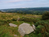
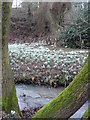
A small promontary fort situated on Stevenshill above Coundmoor Brook. The hill is extremely steep and densely wooded on these sides so despite public footpath access very close to the ramparts on the map, nothing could be discerned.
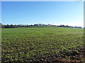
A better view of the location of the fort is afforded from the nearby road back into Cound. An open field undulates up to the rear of the wooded top of the hill. According to the map the bank of the fort crosses this field at some point, but again without much closer inspection nothing could be made out. There was however an area close to what would have been the Northern most part of the fort where what appeared to be an earthen bank was visible in the trees. This seems to fit with the description on Archsearch of a 3m-4m high scarp bank on the NE side of the field boundary.
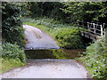
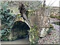
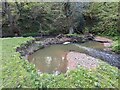
Cound itself is a very pleasant little village and there was ample parking alongside the telephone box. We followed the road until reaching a sharp right angle where we continued along the signposted footpath. (In a nearby field there is nothing to see of the ring ditches/barrow cemetary reported on Archsearch.) This crosses Coundmoor Brook and then follows the brook along the slopes of Stevenshill until reaching the original road that can be then followed back to Cound.
You may be viewing yesterday's version of this page. To see the most up to date information please register for a free account.
")
Do not use the above information on other web sites or publications without permission of the contributor.
coldrum has found this location on Google Street View:
Nearby Images from Geograph Britain and Ireland:
©2015(licence)
©2005(licence)
©2022(licence)
©2010(licence)
©2024(licence)
The above images may not be of the site on this page, they are loaded from Geograph.
Please Submit an Image of this site or go out and take one for us!
Click here to see more info for this site
Nearby sites
Key: Red: member's photo, Blue: 3rd party photo, Yellow: other image, Green: no photo - please go there and take one, Grey: site destroyed
Download sites to:
KML (Google Earth)
GPX (GPS waypoints)
CSV (Garmin/Navman)
CSV (Excel)
To unlock full downloads you need to sign up as a Contributory Member. Otherwise downloads are limited to 50 sites.
Turn off the page maps and other distractions
Nearby sites listing. In the following links * = Image available
1.0km N 354° Cove Coppice* Barrow Cemetery (SJ555046)
3.6km SW 219° The Frog Well Holy Well or Sacred Spring (SJ53340084)
7.3km SW 226° The Lawley (Northern)* Hillfort (SO50289863)
7.5km ESE 119° St Owens Well* Holy Well or Sacred Spring (SO622999)
7.6km ESE 118° Holy Trinity (Much Wenlock)* Ancient Cross (SO623999)
8.4km NW 307° The Burgs* Hillfort (SJ48950873)
8.4km SE 124° St Milburgas Well (Much Wenlock)* Holy Well or Sacred Spring (SO625988)
8.7km SW 224° The Lawley (Summit)* Hillfort (SO49459745)
8.7km NW 322° Shrewsbury Orthodox Church* Cursus (SJ5026310469)
8.7km ENE 57° The Wrekin* Hillfort (SJ630083)
9.4km S 176° Mogg Forest Hillfort* Hillfort (SO5621194262)
9.6km ENE 60° Willow Moor Barrow Cemetary* Barrow Cemetery (SJ640083)
10.4km N 349° Haughmond Hill Camp* Hillfort (SJ537138)
10.8km N 359° Upton Magna* Timber Circle (SJ555144)
11.0km NW 324° High Cross (Shrewsbury) Ancient Cross (SJ492126)
11.2km SW 222° Caer Caradoc Round Barrow* Round Barrow(s) (SO48059529)
11.3km NW 322° Shrewsbury Museum and Art Gallery* Museum (SJ488126)
11.4km SW 223° Caer Caradoc (Church Stretton)* Hillfort (SO477953)
12.2km SW 230° Castle Hill (Shropshire)* Hillfort (SO461959)
12.5km SW 218° Hope Bowdler Hill* Cairn (SO47779389)
12.8km N 355° Ebury Hillfort* Hillfort (SJ546164)
13.2km WSW 238° High Park Cross Dyke* Ancient Village or Settlement (SO443967)
13.2km NE 48° St Margarets Well (Telford) Holy Well or Sacred Spring (SJ656123)
14.2km SW 231° Bodbury Ring* Hillfort (SO445947)
14.3km SW 226° Stretton Sheela* Early Christian Sculptured Stone (SO45239368)
View more nearby sites and additional images


 We would like to know more about this location. Please feel free to add a brief description and any relevant information in your own language.
 Wir möchten mehr über diese Stätte erfahren. Bitte zögern Sie nicht, eine kurze Beschreibung und relevante Informationen in Deutsch hinzuzufügen.
 Nous aimerions en savoir encore un peu sur les lieux. S'il vous plaît n'hesitez pas à ajouter une courte description et tous les renseignements pertinents dans votre propre langue.
 Quisieramos informarnos un poco más de las lugares. No dude en añadir una breve descripción y otros datos relevantes en su propio idioma.