

<< Our Photo Pages >> St Edith's Well (Herefordshire) - Holy Well or Sacred Spring in England in Herefordshire
Submitted by HOLYWELL on Tuesday, 29 August 2006 Page Views: 9013
Springs and Holy WellsSite Name: St Edith's Well (Herefordshire)Country: England
NOTE: This site is 4.101 km away from the location you searched for.
County: Herefordshire Type: Holy Well or Sacred Spring
Nearest Town: Hereford Nearest Village: Stoke Edith
Map Ref: SO604406
Latitude: 52.062352N Longitude: 2.579036W
Condition:
| 5 | Perfect |
| 4 | Almost Perfect |
| 3 | Reasonable but with some damage |
| 2 | Ruined but still recognisable as an ancient site |
| 1 | Pretty much destroyed, possibly visible as crop marks |
| 0 | No data. |
| -1 | Completely destroyed |
| 5 | Superb |
| 4 | Good |
| 3 | Ordinary |
| 2 | Not Good |
| 1 | Awful |
| 0 | No data. |
| 5 | Can be driven to, probably with disabled access |
| 4 | Short walk on a footpath |
| 3 | Requiring a bit more of a walk |
| 2 | A long walk |
| 1 | In the middle of nowhere, a nightmare to find |
| 0 | No data. |
| 5 | co-ordinates taken by GPS or official recorded co-ordinates |
| 4 | co-ordinates scaled from a detailed map |
| 3 | co-ordinates scaled from a bad map |
| 2 | co-ordinates of the nearest village |
| 1 | co-ordinates of the nearest town |
| 0 | no data |
Internal Links:
External Links:
I have visited· I would like to visit
coin visited on 1st Jan 2011 - their rating: Cond: 3 Amb: 4 Access: 3 is this privatley owned?
 (PID:23612)")
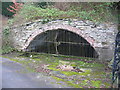
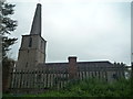
The water of this well arises beneath the church and is easily found. Legend has it that St. Edith prayed for the water she needed to build a church. The water is accredited to healing although the gate over the well is locked and cannot be accessed.
You may be viewing yesterday's version of this page. To see the most up to date information please register for a free account.
 (PID:239464)")
 (PID:239463)")
 (PID:87339)")
Do not use the above information on other web sites or publications without permission of the contributor.
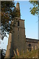
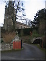
Nearby Images from Geograph Britain and Ireland:
©2005(licence)
©2007(licence)
©2007(licence)
©2019(licence)
©2023(licence)
The above images may not be of the site on this page, they are loaded from Geograph.
Please Submit an Image of this site or go out and take one for us!
Click here to see more info for this site
Nearby sites
Key: Red: member's photo, Blue: 3rd party photo, Yellow: other image, Green: no photo - please go there and take one, Grey: site destroyed
Download sites to:
KML (Google Earth)
GPX (GPS waypoints)
CSV (Garmin/Navman)
CSV (Excel)
To unlock full downloads you need to sign up as a Contributory Member. Otherwise downloads are limited to 50 sites.
Turn off the page maps and other distractions
Nearby sites listing. In the following links * = Image available
2.4km SW 224° Backbury* Hillfort (SO587389)
6.0km SSW 206° Cherry Hill* Hillfort (SO577352)
7.8km S 188° Capler Camp* Hillfort (SO593329)
8.1km WNW 294° The Wergin's Stone* Standing Stone (Menhir) (SO5297543981)
8.5km SSE 160° Oldbury Camp (Herefordshire)* Hillfort (SO632326)
9.0km ESE 106° Redhill Wood Hillfort* Hillfort (SO690380)
9.0km WSW 242° Dinedor Camp* Hillfort (SO524364)
9.1km ESE 105° Wall Hills Camp* Hillfort (SO692382)
9.1km WSW 246° Rotherwas Ribbon* Ancient Trackway (SO52053690)
9.3km W 264° St Ethelbert's Well (Hereford)* Holy Well or Sacred Spring (SO5112239684)
9.5km ENE 72° Bosbury Church Stone* Standing Stone (Menhir) (SO695434)
9.5km W 265° Hereford Museum and Art Gallery* Museum (SO5090039851)
9.5km W 264° The King's Ditch Natural Stone / Erratic / Other Natural Feature (SO50873974)
9.8km NW 306° Sutton Walls* Hillfort (SO525464)
10.1km SW 236° Holy Well (Dinedor)* Holy Well or Sacred Spring (SO52013501)
11.2km NW 305° St Ethelbert's Well (Marden)* Holy Well or Sacred Spring (SO512471)
11.7km SW 231° St Ann's Well (Aconbury)* Holy Well or Sacred Spring (SO51173338)
11.9km S 176° Holy Well (Hole in the wall)* Holy Well or Sacred Spring (SO6109028682)
12.5km SW 233° Aconbury Hill* Hillfort (SO504331)
13.0km SW 225° Higgin's Well* Holy Well or Sacred Spring (SO51163141)
13.4km NE 35° Stanford Bishop Church Stone* Standing Stone (Menhir) (SO682515)
13.6km ESE 119° Haffield Camp* Hillfort (SO72303390)
14.1km NW 323° Dinmore Hill Hillfort (SO520519)
14.7km SSW 197° Picts Cross Stone (Sellack) Standing Stone (Menhir) (SO560266)
14.9km W 276° Holy Well (Garway)* Holy Well or Sacred Spring (SO45554224)
View more nearby sites and additional images


 We would like to know more about this location. Please feel free to add a brief description and any relevant information in your own language.
 Wir möchten mehr über diese Stätte erfahren. Bitte zögern Sie nicht, eine kurze Beschreibung und relevante Informationen in Deutsch hinzuzufügen.
 Nous aimerions en savoir encore un peu sur les lieux. S'il vous plaît n'hesitez pas à ajouter une courte description et tous les renseignements pertinents dans votre propre langue.
 Quisieramos informarnos un poco más de las lugares. No dude en añadir una breve descripción y otros datos relevantes en su propio idioma.