 with our Megalithic Portal iPhone app")

<< Our Photo Pages >> Kirklandhill - Standing Stone (Menhir) in Scotland in East Lothian
Submitted by vicky on Sunday, 22 December 2002 Page Views: 10743
Neolithic and Bronze AgeSite Name: KirklandhillCountry: Scotland County: East Lothian Type: Standing Stone (Menhir)
Nearest Town: Tyninghame Nearest Village: Kirklandhill
Map Ref: NT61687760 Landranger Map Number: 67
Latitude: 55.989826N Longitude: 2.615823W
Condition:
| 5 | Perfect |
| 4 | Almost Perfect |
| 3 | Reasonable but with some damage |
| 2 | Ruined but still recognisable as an ancient site |
| 1 | Pretty much destroyed, possibly visible as crop marks |
| 0 | No data. |
| -1 | Completely destroyed |
| 5 | Superb |
| 4 | Good |
| 3 | Ordinary |
| 2 | Not Good |
| 1 | Awful |
| 0 | No data. |
| 5 | Can be driven to, probably with disabled access |
| 4 | Short walk on a footpath |
| 3 | Requiring a bit more of a walk |
| 2 | A long walk |
| 1 | In the middle of nowhere, a nightmare to find |
| 0 | No data. |
| 5 | co-ordinates taken by GPS or official recorded co-ordinates |
| 4 | co-ordinates scaled from a detailed map |
| 3 | co-ordinates scaled from a bad map |
| 2 | co-ordinates of the nearest village |
| 1 | co-ordinates of the nearest town |
| 0 | no data |
Be the first person to rate this site - see the 'Contribute!' box in the right hand menu.
Internal Links:
External Links:
I have visited· I would like to visit
Monoman would like to visit
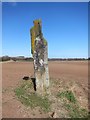
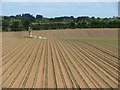
Anne T saw from a distance on 27th Sep 2017 - their rating: Cond: 3 Amb: 3 Access: 5 Kirklandhill Standing Stone, East Lothian: From Pencraig Hill Standing Stone, we drove 3.6 kilometres east along the A199 (which runs parallel to the A1) turning left (north) up the A198. The Kirklandhill Standing Stone is in the middle of the field immediately to the right hand side of the A198.
Whilst the Pencraig Hill Stone was in a field of mature cabbages, this field was planted in well established brussel sprout plants, with no room between them, so we could only view it from the road. We tried looking for a gate into the field off the A198 and the A199, but the entrance must be near to the Kirklandhill Farm building.
I had to content myself with photographing this stone from the edge of the field next to the A198, which was very busy with traffic. Next stop on the list were some standing stones near Traprain Law hillfort.
")
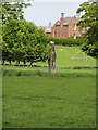
More information on this prehistoric standing stone can be found on Canmore ID 57750 which records: "This standing stone is situated in a cultivated field about 300m SW of Kirklandhill steading. It is 3.36m high and approximately square in section. Its sides are about 0.5m long at ground level."
This standing stone also features on the Ancient Stones website - see their entry for 005 Standing Stone, Kirklandhill, Tyninghame, which gives a description, directions for finding this stone, nearest parking and fieldnotes.
You may be viewing yesterday's version of this page. To see the most up to date information please register for a free account.
")
")
")
")
Do not use the above information on other web sites or publications without permission of the contributor.
Nearby Images from Geograph Britain and Ireland:
©2013(licence)
©2010(licence)
©2007(licence)
©2011(licence)
©2008(licence)
The above images may not be of the site on this page, they are loaded from Geograph.
Please Submit an Image of this site or go out and take one for us!
Click here to see more info for this site
Nearby sites
Key: Red: member's photo, Blue: 3rd party photo, Yellow: other image, Green: no photo - please go there and take one, Grey: site destroyed
Download sites to:
KML (Google Earth)
GPX (GPS waypoints)
CSV (Garmin/Navman)
CSV (Excel)
To unlock full downloads you need to sign up as a Contributory Member. Otherwise downloads are limited to 50 sites.
Turn off the page maps and other distractions
Nearby sites listing. In the following links * = Image available
1.7km WNW 286° Prestonkirk Cursus Cursus (NT60007809)
2.1km W 280° Prestonkirk Cursus Cursus (NT59657799)
2.4km W 274° St Baldred's Well* Holy Well or Sacred Spring (NT59317780)
2.5km W 278° Prestonkirk Cursus Cursus (NT59257798)
2.8km W 276° Prestonkirk Cursus Cursus (NT58927790)
3.3km SSE 167° Rood Well* Holy Well or Sacred Spring (NT6237674417)
3.7km WSW 257° Pencraig Brae* Standing Stone (Menhir) (NT58087681)
4.4km SW 229° Maiden Stone (East Lothian)* Standing Stone (Menhir) (NT5830774748)
4.4km NNW 334° Our Lady's Well (Whitekirk) Holy Well or Sacred Spring (NT598816)
4.6km SW 231° Traprain Law* Hillfort (NT5805674696)
5.2km SW 228° Loth Stone* Standing Stone (Menhir) (NT5782374146)
5.6km SW 224° Standingstone (East Lothian)* Standing Stone (Menhir) (NT57737363)
5.7km ESE 114° Witches' Stone (Spott)* Holy Well or Sacred Spring (NT66917520)
5.9km ESE 109° St John's Well (Spott)* Holy Well or Sacred Spring (NT67277561)
6.4km E 98° Easter Broomhouse* Standing Stone (Menhir) (NT6800876615)
7.3km ESE 106° Doon Hill Dunbar* Ancient Village or Settlement (NT6868775539)
7.3km NNW 339° St. Baldred's Well (Auldhame)* Holy Well or Sacred Spring (NT59168450)
8.4km E 91° Broxmouth Hill Fort* Hillfort (NT7011177388)
8.8km NW 315° North Berwick Law* Ancient Village or Settlement (NT555839)
9.0km S 182° White Castle Fort* Hillfort (NT61356860)
9.5km WNW 283° Boar Stone (Drem)* Ancient Cross (NT52427975)
9.8km NW 320° St. Andrew's Well Holy Well or Sacred Spring (NT55438520)
9.9km W 262° Kaeheughs Hillfort (NT51837627)
10.5km S 178° Ragstone Rig (Cranshaws) Stone Row / Alignment (NT61956705)
10.6km WSW 249° Custom Stone (Haddington) Marker Stone (NT51697388)
View more nearby sites and additional images


 We would like to know more about this location. Please feel free to add a brief description and any relevant information in your own language.
 Wir möchten mehr über diese Stätte erfahren. Bitte zögern Sie nicht, eine kurze Beschreibung und relevante Informationen in Deutsch hinzuzufügen.
 Nous aimerions en savoir encore un peu sur les lieux. S'il vous plaît n'hesitez pas à ajouter une courte description et tous les renseignements pertinents dans votre propre langue.
 Quisieramos informarnos un poco más de las lugares. No dude en añadir una breve descripción y otros datos relevantes en su propio idioma.