


<< Our Photo Pages >> The Written Stone - Sculptured Stone in England in Lancashire
Submitted by Sunny100 on Tuesday, 09 April 2019 Page Views: 5207
Multi-periodSite Name: The Written Stone Alternative Name: The Ralph Radcliffe StoneCountry: England
NOTE: This site is 2.015 km away from the location you searched for.
County: Lancashire Type: Sculptured Stone
Nearest Town: Longridge Nearest Village: Grimsargh
Map Ref: SD6262237892
Latitude: 53.835928N Longitude: 2.569463W
Condition:
| 5 | Perfect |
| 4 | Almost Perfect |
| 3 | Reasonable but with some damage |
| 2 | Ruined but still recognisable as an ancient site |
| 1 | Pretty much destroyed, possibly visible as crop marks |
| 0 | No data. |
| -1 | Completely destroyed |
| 5 | Superb |
| 4 | Good |
| 3 | Ordinary |
| 2 | Not Good |
| 1 | Awful |
| 0 | No data. |
| 5 | Can be driven to, probably with disabled access |
| 4 | Short walk on a footpath |
| 3 | Requiring a bit more of a walk |
| 2 | A long walk |
| 1 | In the middle of nowhere, a nightmare to find |
| 0 | No data. |
| 5 | co-ordinates taken by GPS or official recorded co-ordinates |
| 4 | co-ordinates scaled from a detailed map |
| 3 | co-ordinates scaled from a bad map |
| 2 | co-ordinates of the nearest village |
| 1 | co-ordinates of the nearest town |
| 0 | no data |
Internal Links:
External Links:
")
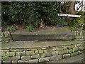
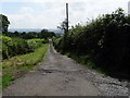
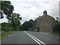
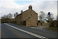
The inscribed stone, known locally as ‘The Written Stone’, stands at the side of the lane close by the entrance to Written Stone Farm, originally called Cottam House. The B6243 Longridge to Hurst Green road runs past the lane where the mysterious Written Stone is located.
It became known as ‘the cursed stone’ after a murder took place here. Later, very strange and ghostly things began to manifest when the farmer decided to try and move it and put it into use as a "buttery stone" but, he had to return the stone to its original resting place, when ‘all hell let loose’, according to local legend. The stone is set into the bank above a wall close by the entrance to Written Stone farm, on the left-hand side of the lane, which was also known as Boggart Lane.
In recent times it has been suggested that the stone originated on the fells to the northwest, where it may have formed part of a stone circle, and was possibly a pagan altar stone; another suggestion being that it was a lintel stone from above a doorway, and yet another theory being that it was an outlier. But all this is just conjecture. The Roman road linking the forts of Ribchester and Lancaster intersects with Written Stone Lane.
For more details and references see the site page on my Journal of Antiquities for The Written Stone, Grimsargh.
You may be viewing yesterday's version of this page. To see the most up to date information please register for a free account.
Do not use the above information on other web sites or publications without permission of the contributor.
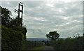
Nearby Images from Geograph Britain and Ireland:
©2008(licence)
©2019(licence)
©2010(licence)
©2006(licence)
©2022(licence)
The above images may not be of the site on this page, they are loaded from Geograph.
Please Submit an Image of this site or go out and take one for us!
Click here to see more info for this site
Nearby sites
Key: Red: member's photo, Blue: 3rd party photo, Yellow: other image, Green: no photo - please go there and take one, Grey: site destroyed
Download sites to:
KML (Google Earth)
GPX (GPS waypoints)
CSV (Garmin/Navman)
CSV (Excel)
To unlock full downloads you need to sign up as a Contributory Member. Otherwise downloads are limited to 50 sites.
Turn off the page maps and other distractions
Nearby sites listing. In the following links * = Image available
3.1km NE 35° Jeffrey Hill Cairn Circle* Cairn (SD644404)
3.2km NE 36° Thornley Hall Fell Cairn* Round Barrow(s) (SD64524047)
3.4km SE 124° St Saviour's Churchyard (Stydd) Ancient Cross (SD6539435971)
3.7km SE 141° St Wilfrid's Church (Ribchester)* Ancient Cross (SD649350)
6.3km SSW 197° Marsden Well/Spring* Holy Well or Sacred Spring (SD607319)
6.5km ENE 67° Kemple End Cross* Ancient Cross (SD6864240438)
7.3km SSE 159° Mellor Brow Mound* Misc. Earthwork (SD6517231081)
7.3km E 93° Billington Round Barrow(s) (SD699375)
7.7km NNW 336° Parlick Pike Cairn* Cairn (SD59574502)
8.0km W 279° St Anne's Well (Inglewhite)* Holy Well or Sacred Spring (SD547392)
8.0km E 93° Winckley Lowe I* Round Barrow(s) (SD7064337457)
8.2km WSW 238° Our Lady's Well, Fernyhalgh* Holy Well or Sacred Spring (SD55613362)
8.2km E 94° Winckley Lowe II* Round Barrow(s) (SD7084937308)
8.4km ENE 71° Withgill Cross (Great Mitton) Ancient Cross (SD70604062)
8.7km ENE 78° Mitton Green Cross (Great Mitton) Ancient Cross (SD7121739613)
9.0km E 83° The Great Mitton Cross* Ancient Cross (SD7156438954)
9.1km W 266° Barton Cross Ancient Cross (SD5350037332)
9.1km SSE 152° Beardwood Holed Stone* Holed Stone (SD6684829793)
9.3km NNE 18° Fairy Holes* Cave or Rock Shelter (SD65534678)
9.5km NNW 328° Bleasdale* Timber Circle (SD5771145994)
9.8km SSE 151° Revidge Moor Barrow* Round Barrow(s) (SD674293)
10.7km E 99° Whalley Crosses* Ancient Cross (SD73263616)
10.8km E 99° St Mary and All Saints Church (Whalley)* Sculptured Stone (SD733361)
10.9km SSE 168° Pleasington Cemetery (Blackburn) Cairn (SD649272)
11.0km E 94° High Wall Well (Bramley Meade)* Holy Well or Sacred Spring (SD73663702)
View more nearby sites and additional images


 We would like to know more about this location. Please feel free to add a brief description and any relevant information in your own language.
 Wir möchten mehr über diese Stätte erfahren. Bitte zögern Sie nicht, eine kurze Beschreibung und relevante Informationen in Deutsch hinzuzufügen.
 Nous aimerions en savoir encore un peu sur les lieux. S'il vous plaît n'hesitez pas à ajouter une courte description et tous les renseignements pertinents dans votre propre langue.
 Quisieramos informarnos un poco más de las lugares. No dude en añadir una breve descripción y otros datos relevantes en su propio idioma.