


<< Our Photo Pages >> Miles Well - Holy Well or Sacred Spring in England in Gloucestershire
Submitted by dooclay on Saturday, 16 July 2022 Page Views: 422
Springs and Holy WellsSite Name: Miles Well Alternative Name: St Michaels WellCountry: England
NOTE: This site is 1.44 km away from the location you searched for.
County: Gloucestershire Type: Holy Well or Sacred Spring
Nearest Town: Thornbury Nearest Village: Tockington
Map Ref: ST6036486654
Latitude: 51.577347N Longitude: 2.573368W
Condition:
| 5 | Perfect |
| 4 | Almost Perfect |
| 3 | Reasonable but with some damage |
| 2 | Ruined but still recognisable as an ancient site |
| 1 | Pretty much destroyed, possibly visible as crop marks |
| 0 | No data. |
| -1 | Completely destroyed |
| 5 | Superb |
| 4 | Good |
| 3 | Ordinary |
| 2 | Not Good |
| 1 | Awful |
| 0 | No data. |
| 5 | Can be driven to, probably with disabled access |
| 4 | Short walk on a footpath |
| 3 | Requiring a bit more of a walk |
| 2 | A long walk |
| 1 | In the middle of nowhere, a nightmare to find |
| 0 | No data. |
| 5 | co-ordinates taken by GPS or official recorded co-ordinates |
| 4 | co-ordinates scaled from a detailed map |
| 3 | co-ordinates scaled from a bad map |
| 2 | co-ordinates of the nearest village |
| 1 | co-ordinates of the nearest town |
| 0 | no data |
Internal Links:
External Links:
")
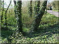
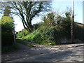
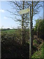
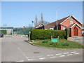
Right next to the minor road between Tockington and Alveston. There is a road sign on the pavement next to it. The Well enclosure is visible but the well is not being buried and overgrown.
You may be viewing yesterday's version of this page. To see the most up to date information please register for a free account.
Do not use the above information on other web sites or publications without permission of the contributor.
Nearby Images from Geograph Britain and Ireland:
©2019(licence)
©2019(licence)
©2019(licence)
©2019(licence)
©2019(licence)
The above images may not be of the site on this page, they are loaded from Geograph.
Please Submit an Image of this site or go out and take one for us!
Click here to see more info for this site
Nearby sites
Key: Red: member's photo, Blue: 3rd party photo, Yellow: other image, Green: no photo - please go there and take one, Grey: site destroyed
Download sites to:
KML (Google Earth)
GPX (GPS waypoints)
CSV (Garmin/Navman)
CSV (Excel)
To unlock full downloads you need to sign up as a Contributory Member. Otherwise downloads are limited to 50 sites.
Turn off the page maps and other distractions
Nearby sites listing. In the following links * = Image available
622m SE 128° Rams Well* Holy Well or Sacred Spring (ST6085186266)
1.8km NNE 14° Elberton Camp* Hillfort (ST60808840)
2.8km NE 53° Alveston Round Barrow* Round Barrow(s) (ST62608831)
3.0km E 79° Fishmonger's Swallet Cave or Rock Shelter (ST63318720)
3.4km SSW 192° Knole Park Camp* Hillfort (ST59638334)
3.9km NNE 20° St Arilds Well* Holy Well or Sacred Spring (ST61759030)
5.1km ENE 66° Abbey Camp* Hillfort (ST65008870)
5.3km N 5° St Arilda's, Oldbury-on-Severn* Artificial Mound (ST60839191)
5.7km N 8° Oldbury Standing Stone* Standing Stone (Menhir) (ST61169234)
5.9km S 190° Highwood Road Modern Menhir* Modern Stone Circle etc (ST5928080878)
6.1km N 6° The Toots (Oldbury)* Hillfort (ST611927)
6.3km ENE 74° Tytherington Camp* Promontory Fort / Cliff Castle (ST66438834)
6.5km WNW 301° St Tecla's Chapel & Holy Well Holy Well or Sacred Spring (ST5484390020)
7.8km N 356° Oldbury-on-Severn Submerged Forest* Natural Stone / Erratic / Other Natural Feature (ST59849440)
8.1km NE 41° Camp Hill (Rockhampton)* Hillfort (ST657927)
8.1km NW 308° Thornwell Farm* Chambered Tomb (ST53959167)
8.2km NW 309° Thornwell Round Barrow* Round Barrow(s) (ST540918)
8.3km ESE 112° Iron Acton Churchyard Cross* Ancient Cross (ST6807583467)
8.8km NW 313° St Peter's Cave Cave or Rock Shelter (ST539927)
8.9km NE 36° Rockhampton Standing Stone* Marker Stone (ST65679378)
9.0km NW 312° The Bulwarks (Monmouthshire)* Hillfort (ST53789274)
9.0km SSE 147° Bury Hill Camp (Winterbourne)* Hillfort (ST652791)
9.1km SSW 195° Southmead Barrow* Round Barrow(s) (ST5794477902)
9.2km WNW 299° St Tewdric's Well* Holy Well or Sacred Spring (ST5227991167)
9.4km S 174° Stoke Park Long Barrow* Long Barrow (ST6132077294)
View more nearby sites and additional images


 We would like to know more about this location. Please feel free to add a brief description and any relevant information in your own language.
 Wir möchten mehr über diese Stätte erfahren. Bitte zögern Sie nicht, eine kurze Beschreibung und relevante Informationen in Deutsch hinzuzufügen.
 Nous aimerions en savoir encore un peu sur les lieux. S'il vous plaît n'hesitez pas à ajouter une courte description et tous les renseignements pertinents dans votre propre langue.
 Quisieramos informarnos un poco más de las lugares. No dude en añadir una breve descripción y otros datos relevantes en su propio idioma.