


<< Our Photo Pages >> Aylburton Cross - Ancient Cross in England in Gloucestershire
Submitted by dooclay on Saturday, 13 May 2023 Page Views: 198
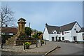
Early Medieval (Dark Age)Site Name: Aylburton CrossCountry: England County: Gloucestershire Type: Ancient Cross
Nearest Village: Aylburton
Map Ref: SO6172101791
Latitude: 51.713535N Longitude: 2.555448W
Condition:
| 5 | Perfect |
| 4 | Almost Perfect |
| 3 | Reasonable but with some damage |
| 2 | Ruined but still recognisable as an ancient site |
| 1 | Pretty much destroyed, possibly visible as crop marks |
| 0 | No data. |
| -1 | Completely destroyed |
| 5 | Superb |
| 4 | Good |
| 3 | Ordinary |
| 2 | Not Good |
| 1 | Awful |
| 0 | No data. |
| 5 | Can be driven to, probably with disabled access |
| 4 | Short walk on a footpath |
| 3 | Requiring a bit more of a walk |
| 2 | A long walk |
| 1 | In the middle of nowhere, a nightmare to find |
| 0 | No data. |
| 5 | co-ordinates taken by GPS or official recorded co-ordinates |
| 4 | co-ordinates scaled from a detailed map |
| 3 | co-ordinates scaled from a bad map |
| 2 | co-ordinates of the nearest village |
| 1 | co-ordinates of the nearest town |
| 0 | no data |
Internal Links:
External Links:
")
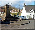
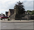
From Gloucestershire KYP: The monument includes a village cross on a five step calvary, situated by the side of the road at a road junction in the village of Aylburton. The cross includes a five step calvary and pedestal. The first step of the calvary is 4.2Sm square and 0.3m high. The other four steps rising from this decrease in size with the top step being 1.lSm square. Each step is c.0.3m high. These five steps are composed of old weathered stone blocks cemented together. Above this is a pedestal or capital. The capital is in the form of four canopied niches c.2m high. The first two steps of the calvary are built of red sandstone; the remainder of the steps and capital of grey forest stone. The total height of the cross is c.3.6m. The stone blocks of the calvary and the capital are early 14th century, but the shaft and head are later. A plate of the cross depicted in Pooley's notes published in 1868 shows the cross in the same condition as today, without socket stone and shaft. Pooley notes that the cross was repaired about 1841.
You may be viewing yesterday's version of this page. To see the most up to date information please register for a free account.
Do not use the above information on other web sites or publications without permission of the contributor.
Nearby Images from Geograph Britain and Ireland:
©2012(licence)
©2017(licence)
©2021(licence)
©2021(licence)
©2023(licence)
The above images may not be of the site on this page, they are loaded from Geograph.
Please Submit an Image of this site or go out and take one for us!
Click here to see more info for this site
Nearby sites
Key: Red: member's photo, Blue: 3rd party photo, Yellow: other image, Green: no photo - please go there and take one, Grey: site destroyed
Download sites to:
KML (Google Earth)
GPX (GPS waypoints)
CSV (Garmin/Navman)
CSV (Excel)
To unlock full downloads you need to sign up as a Contributory Member. Otherwise downloads are limited to 50 sites.
Turn off the page maps and other distractions
Nearby sites listing. In the following links * = Image available
917m N 352° Lydney Hillfort* Hillfort (SO616027)
3.0km E 100° Lydney Harbour* Modern Stone Circle etc (SO64730126)
6.0km WSW 254° East Wood Ring Cairn* Ring Cairn (SO5594600157)
6.0km SW 221° Broad Stone (Gloucestershire)* Standing Stone (Menhir) (ST5776397247)
6.2km SE 141° Blisbury Hill Camp* Hillfort (ST65569692)
6.3km WNW 293° The Ancient Barrow Well, St. Briavel's* Holy Well or Sacred Spring (SO5593004337)
6.6km WNW 294° St Bride's Well* Holy Well or Sacred Spring (SO5574404515)
7.0km NW 311° Stowe Enclosure* Misc. Earthwork (SO56430643)
7.2km W 266° Cup Stone on Mill Hill* Rock Art (SO545014)
7.2km WSW 242° Soldier's Tump* Round Barrow(s) (ST55289849)
7.2km E 93° Wanswell Holy Well or Sacred Spring (SO68980139)
7.6km NNW 328° Clearwell Caves* Ancient Mine, Quarry or other Industry (SO57700822)
7.6km NNW 331° Gattle's Cross* Marker Stone (SO5812608512)
7.6km SSW 194° Oldbury-on-Severn Submerged Forest* Natural Stone / Erratic / Other Natural Feature (ST59849440)
7.7km WSW 258° Offa's Dyke near Brockweir* Misc. Earthwork (SO541003)
7.9km WSW 240° Offa's Dyke at Tidenham Chase* Misc. Earthwork (ST548979)
8.1km NNE 27° Drummer Boys Grave Stone* Ancient Mine, Quarry or other Industry (SO65470898)
8.7km NNE 26° Patten Stone Marker Stone (SO65640959)
8.9km SSE 153° Rockhampton Standing Stone* Marker Stone (ST65679378)
9.0km SW 235° Spital Meend* Promontory Fort / Cliff Castle (ST54269671)
9.1km S 183° The Toots (Oldbury)* Hillfort (ST611927)
9.2km WSW 252° Blackfield Wood* Hillfort (ST529990)
9.5km S 183° Oldbury Standing Stone* Standing Stone (Menhir) (ST61169234)
9.6km W 264° Lower Halewood Round Barrow(s) (SO521009)
9.7km W 265° Tintern 1* Round Barrow(s) (SO5207200980)
View more nearby sites and additional images


 We would like to know more about this location. Please feel free to add a brief description and any relevant information in your own language.
 Wir möchten mehr über diese Stätte erfahren. Bitte zögern Sie nicht, eine kurze Beschreibung und relevante Informationen in Deutsch hinzuzufügen.
 Nous aimerions en savoir encore un peu sur les lieux. S'il vous plaît n'hesitez pas à ajouter une courte description et tous les renseignements pertinents dans votre propre langue.
 Quisieramos informarnos un poco más de las lugares. No dude en añadir una breve descripción y otros datos relevantes en su propio idioma.