

<< Our Photo Pages >> Church of St Mary the Virgin (Acton) - Ancient Cross in England in Cheshire
Submitted by TimPrevett on Sunday, 11 February 2007 Page Views: 6902
Early Medieval (Dark Age)Site Name: Church of St Mary the Virgin (Acton)Country: England
NOTE: This site is 3.667 km away from the location you searched for.
County: Cheshire Type: Ancient Cross
Nearest Town: Nantwich Nearest Village: Acton
Map Ref: SJ63175308
Latitude: 53.073673N Longitude: 2.551172W
Condition:
| 5 | Perfect |
| 4 | Almost Perfect |
| 3 | Reasonable but with some damage |
| 2 | Ruined but still recognisable as an ancient site |
| 1 | Pretty much destroyed, possibly visible as crop marks |
| 0 | No data. |
| -1 | Completely destroyed |
| 5 | Superb |
| 4 | Good |
| 3 | Ordinary |
| 2 | Not Good |
| 1 | Awful |
| 0 | No data. |
| 5 | Can be driven to, probably with disabled access |
| 4 | Short walk on a footpath |
| 3 | Requiring a bit more of a walk |
| 2 | A long walk |
| 1 | In the middle of nowhere, a nightmare to find |
| 0 | No data. |
| 5 | co-ordinates taken by GPS or official recorded co-ordinates |
| 4 | co-ordinates scaled from a detailed map |
| 3 | co-ordinates scaled from a bad map |
| 2 | co-ordinates of the nearest village |
| 1 | co-ordinates of the nearest town |
| 0 | no data |
Internal Links:
External Links:
 (PID:27331)")
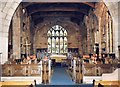
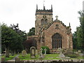
Some Saxon fragments remaining in Acton church, which is on the site of an earlier Saxon structure. The fragments are at the east end of the church, facing the impressive Wilbraham Memorial. Access is pretty much limited to church services, or unless by prior arrangement. Not hugely impressive in themselves, visiting these is pretty much for the enthusiast.
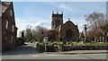
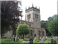
The church is an interesting mix of styles, inside and out, and the churchyard has several other features of interest whilst there. Cricketing buffs might be pleased to know there is the grave of Albert Neilson Hornby in the east of the churchyard near the main road (look for the cricket stumps etc on the memorial!); some 17th century almshouses, and a monumental sundial.
You may be viewing yesterday's version of this page. To see the most up to date information please register for a free account.
Do not use the above information on other web sites or publications without permission of the contributor.
Nearby Images from Geograph Britain and Ireland:
©2012(licence)
©2016(licence)

©2023(licence)
©2013(licence)
©2013(licence)
The above images may not be of the site on this page, they are loaded from Geograph.
Please Submit an Image of this site or go out and take one for us!
Click here to see more info for this site
Nearby sites
Key: Red: member's photo, Blue: 3rd party photo, Yellow: other image, Green: no photo - please go there and take one, Grey: site destroyed
Download sites to:
KML (Google Earth)
GPX (GPS waypoints)
CSV (Garmin/Navman)
CSV (Excel)
To unlock full downloads you need to sign up as a Contributory Member. Otherwise downloads are limited to 50 sites.
Turn off the page maps and other distractions
Nearby sites listing. In the following links * = Image available
1.9km ESE 110° Old Biot* Holy Well or Sacred Spring (SJ64965243)
8.9km NW 320° Robin Hood's Tump* Round Barrow(s) (SJ575599)
9.8km SSE 163° St James the Great, Audlem* Round Barrow(s) (SJ66004365)
9.8km SSE 163° The Bear Stone* Natural Stone / Erratic / Other Natural Feature (SJ66004365)
10.0km WNW 297° Peckforton Mere* Ancient Village or Settlement (SJ543577)
11.2km WNW 303° Beeston Castle* Hillfort (SJ538592)
12.9km NW 321° Salterswell* Holy Well or Sacred Spring (SJ552632)
13.3km W 269° Maiden Castle (Cheshire)* Hillfort (SJ49805286)
14.8km ENE 58° Sandbach Crosses* Ancient Cross (SJ7587760825)
15.0km NNW 347° Long Stone Cross* Ancient Cross (SJ599677)
15.2km NNW 329° High Billinge* Round Barrow(s) (SJ5548066242)
15.4km NNW 335° Seven Lows* Round Barrow(s) (SJ567671)
15.5km NNW 333° Seven Lows Round Barrow(s) (SJ56336703)
15.7km NNW 339° Oakmere* Ancient Village or Settlement (SJ576678)
15.9km W 277° St Winefride's (Clutton)* Holy Well or Sacred Spring (SJ47395524)
16.1km SSE 153° Bradling Stone* Standing Stone (Menhir) (SJ70333864)
16.1km NNW 328° Whistlebitch Well* Holy Well or Sacred Spring (SJ548669)
16.5km N 7° Moultonbank Farm Round Barrow(s) (SJ653694)
16.8km W 271° Carden Park Barrow Round Barrow(s) (SJ46365352)
16.8km W 272° Carden Park* Cave or Rock Shelter (SJ463537)
17.0km SSE 153° Devil's Ring and Finger* Holed Stone (SJ7072737783)
17.2km SW 230° Warren Tump (Wrexham)* Round Barrow(s) (SJ49974206)
17.2km SSE 159° Betton Standing Stone (Menhir) (SJ69193691)
17.2km NW 308° Brookhouse Farm Ancient Village or Settlement (SJ497639)
17.5km SSE 156° The Ineaz Stone Standing Stone (Menhir) (SJ70223706)
View more nearby sites and additional images


 We would like to know more about this location. Please feel free to add a brief description and any relevant information in your own language.
 Wir möchten mehr über diese Stätte erfahren. Bitte zögern Sie nicht, eine kurze Beschreibung und relevante Informationen in Deutsch hinzuzufügen.
 Nous aimerions en savoir encore un peu sur les lieux. S'il vous plaît n'hesitez pas à ajouter une courte description et tous les renseignements pertinents dans votre propre langue.
 Quisieramos informarnos un poco más de las lugares. No dude en añadir una breve descripción y otros datos relevantes en su propio idioma.