

<< Our Photo Pages >> Beardwood Holed Stone - Holed Stone in England in Lancashire
Submitted by ESgt on Wednesday, 25 June 2014 Page Views: 4515
Neolithic and Bronze AgeSite Name: Beardwood Holed StoneCountry: England County: Lancashire Type: Holed Stone
Nearest Town: Blackburn
Map Ref: SD6684829793
Latitude: 53.763425N Longitude: 2.504375W
Condition:
| 5 | Perfect |
| 4 | Almost Perfect |
| 3 | Reasonable but with some damage |
| 2 | Ruined but still recognisable as an ancient site |
| 1 | Pretty much destroyed, possibly visible as crop marks |
| 0 | No data. |
| -1 | Completely destroyed |
| 5 | Superb |
| 4 | Good |
| 3 | Ordinary |
| 2 | Not Good |
| 1 | Awful |
| 0 | No data. |
| 5 | Can be driven to, probably with disabled access |
| 4 | Short walk on a footpath |
| 3 | Requiring a bit more of a walk |
| 2 | A long walk |
| 1 | In the middle of nowhere, a nightmare to find |
| 0 | No data. |
| 5 | co-ordinates taken by GPS or official recorded co-ordinates |
| 4 | co-ordinates scaled from a detailed map |
| 3 | co-ordinates scaled from a bad map |
| 2 | co-ordinates of the nearest village |
| 1 | co-ordinates of the nearest town |
| 0 | no data |
Internal Links:
External Links:
")
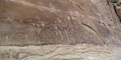
The 3 ft high holed stone at this location, by the side of a footpath, was notified to The Society of Ley hunters by Mr Graham Clitheroe of Blackburn. It appears to have some significant alignments across it.
For more information see: Blackburn Alignment.
You may be viewing yesterday's version of this page. To see the most up to date information please register for a free account.
Do not use the above information on other web sites or publications without permission of the contributor.
Nearby Images from Geograph Britain and Ireland:
©2019(licence)
©2015(licence)
©2019(licence)
©2015(licence)
©2009(licence)
The above images may not be of the site on this page, they are loaded from Geograph.
Please Submit an Image of this site or go out and take one for us!
Click here to see more info for this site
Nearby sites
Key: Red: member's photo, Blue: 3rd party photo, Yellow: other image, Green: no photo - please go there and take one, Grey: site destroyed
Download sites to:
KML (Google Earth)
GPX (GPS waypoints)
CSV (Garmin/Navman)
CSV (Excel)
To unlock full downloads you need to sign up as a Contributory Member. Otherwise downloads are limited to 50 sites.
![]()
Turn off the page maps and other distractions
Nearby sites listing. In the following links * = Image available
739m SE 131° Revidge Moor Barrow* Round Barrow(s) (SD674293)
2.1km NW 307° Mellor Brow Mound* Misc. Earthwork (SD6517231081)
3.2km SW 216° Pleasington Cemetery (Blackburn) Cairn (SD649272)
5.6km NNW 339° St Wilfrid's Church (Ribchester)* Ancient Cross (SD649350)
6.3km NNW 346° St Saviour's Churchyard (Stydd) Ancient Cross (SD6539435971)
6.5km WNW 289° Marsden Well/Spring* Holy Well or Sacred Spring (SD607319)
6.8km S 188° Tocca's Stone* Ancient Cross (SD65842302)
8.3km ESE 122° Cocker Cobb* Stone Circle (SD7385225360)
8.3km NNE 21° Billington Round Barrow(s) (SD699375)
8.5km NNE 28° Winckley Lowe II* Round Barrow(s) (SD7084937308)
8.5km NNE 26° Winckley Lowe I* Round Barrow(s) (SD7064337457)
9.0km NE 45° St Mary and All Saints Church (Whalley)* Sculptured Stone (SD733361)
9.0km NE 45° Whalley Crosses* Ancient Cross (SD73263616)
9.1km NNW 332° The Written Stone* Sculptured Stone (SD6262237892)
9.4km SSE 163° White Hall* Round Barrow(s) (SD696208)
9.6km NE 53° Portfield* Hillfort (SD7458135499)
9.9km S 182° Hollinshead Holy Well* Holy Well or Sacred Spring (SD66361994)
9.9km NE 43° High Wall Well (Bramley Meade)* Holy Well or Sacred Spring (SD73663702)
10.3km NNE 27° The Great Mitton Cross* Ancient Cross (SD7156438954)
10.7km NNE 24° Mitton Green Cross (Great Mitton) Ancient Cross (SD7121739613)
10.8km NE 45° Wisa's Well (Wiswell)* Holy Well or Sacred Spring (SD746373)
10.8km N 9° Kemple End Cross* Ancient Cross (SD6864240438)
10.9km NNW 347° Jeffrey Hill Cairn Circle* Cairn (SD644404)
10.9km NNW 347° Thornley Hall Fell Cairn* Round Barrow(s) (SD64524047)
11.1km WSW 238° Hawksclough Hillfort (SD574240)
View more nearby sites and additional images


 We would like to know more about this location. Please feel free to add a brief description and any relevant information in your own language.
 Wir möchten mehr über diese Stätte erfahren. Bitte zögern Sie nicht, eine kurze Beschreibung und relevante Informationen in Deutsch hinzuzufügen.
 Nous aimerions en savoir encore un peu sur les lieux. S'il vous plaît n'hesitez pas à ajouter une courte description et tous les renseignements pertinents dans votre propre langue.
 Quisieramos informarnos un poco más de las lugares. No dude en añadir una breve descripción y otros datos relevantes en su propio idioma.