


<< Our Photo Pages >> Doon Hill Dunbar - Ancient Village or Settlement in Scotland in East Lothian
Submitted by drolaf on Thursday, 02 July 2020 Page Views: 5161
Neolithic and Bronze AgeSite Name: Doon Hill Dunbar Alternative Name: DoonhillCountry: Scotland County: East Lothian Type: Ancient Village or Settlement
Nearest Town: Dunbar Nearest Village: Spott
Map Ref: NT6868775539
Latitude: 55.971820N Longitude: 2.50327W
Condition:
| 5 | Perfect |
| 4 | Almost Perfect |
| 3 | Reasonable but with some damage |
| 2 | Ruined but still recognisable as an ancient site |
| 1 | Pretty much destroyed, possibly visible as crop marks |
| 0 | No data. |
| -1 | Completely destroyed |
| 5 | Superb |
| 4 | Good |
| 3 | Ordinary |
| 2 | Not Good |
| 1 | Awful |
| 0 | No data. |
| 5 | Can be driven to, probably with disabled access |
| 4 | Short walk on a footpath |
| 3 | Requiring a bit more of a walk |
| 2 | A long walk |
| 1 | In the middle of nowhere, a nightmare to find |
| 0 | No data. |
| 5 | co-ordinates taken by GPS or official recorded co-ordinates |
| 4 | co-ordinates scaled from a detailed map |
| 3 | co-ordinates scaled from a bad map |
| 2 | co-ordinates of the nearest village |
| 1 | co-ordinates of the nearest town |
| 0 | no data |
Internal Links:
External Links:
I have visited· I would like to visit
drolaf has visited here
")
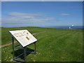
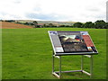
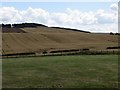
Doon Hill is a deceivingly innocuous undramatic hill to look at, but its key lies in its location, on the eastern edge of the Lammamuirs, giving extensive views of the entire coastal plain from North Berwick to St Abbs. This area of East Lothian was important in the Mesolithic, with a very early settlement found at East Barns and another further south at Lowick. One of the attractions of the north in the Mesolithic may have been the relatively stable sea levels, due to land rebound equalising sea level rise. There was continued occupation in the area throughout the Neolithic, Bronze and Iron Ages.
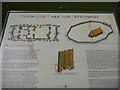
The hill is the site of Neolithic cremations and a small associated rectangular structure. Slightly to the south is the site of a rectangular building, possibly roofed originally, but not necessarily. It is of a form very similar to rectangular timber structures of a Neolithic timescale, such as Balbridie and Sprouston (see Millican 2016). Massive posts in the interior are indicative of a Neolithic date. The massive timber structures of the time period must have presented similar construction challenges as moving large stones.
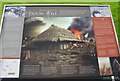
Inside this site is a much later 'Anglo-Saxon' hall constructed in about 640 AD. This raises questions of how the Northumbrians of 600 AD knew that there was an ancient building on the site. Perhaps, as we see at sites today, it showed up as field marks in summer droughts, and this was a signal to build on the site.
The site would have given the Northumbrians a strategic view of any movement in the plain below, or coastal sea transport.
Access-a short walk from the lane. Ambience-fantastic views and feeling of long distance links. Outline of halls laid out and a plaque, showing deliberate burning of the hall, which is unfortunate as it was just as probably accidental.
Web links and references
Site maps:
https://scotlandsplaces.gov.uk/record/hes/57668/doon-hill/rcahms?item=936733
trig panorama:
http://www.panoramicearth.com/8950/Dunbar/Doon_Hill_Trig_Point
Millican K. 2016 Seeing the wood in the trees: the timber monuments of Neolithic |Scotland, Chapter 8 in The Neolithic of Mainland Scotland. Eds Brophy K, MacGregor G, Ralston I. Edinburgh University Press
Local Bronze Age:
http://www.megalithic.co.uk/article.php?sid=2146410532
Mesolithic East Barnes:
https://canmore.org.uk/site/212799/dunbar-east-barns
You may be viewing yesterday's version of this page. To see the most up to date information please register for a free account.
")
")
Do not use the above information on other web sites or publications without permission of the contributor.
Nearby Images from Geograph Britain and Ireland:
©2010(licence)
©2010(licence)
©2012(licence)
©2012(licence)
©2014(licence)
The above images may not be of the site on this page, they are loaded from Geograph.
Please Submit an Image of this site or go out and take one for us!
Click here to see more info for this site
Nearby sites
Key: Red: member's photo, Blue: 3rd party photo, Yellow: other image, Green: no photo - please go there and take one, Grey: site destroyed
Download sites to:
KML (Google Earth)
GPX (GPS waypoints)
CSV (Garmin/Navman)
CSV (Excel)
To unlock full downloads you need to sign up as a Contributory Member. Otherwise downloads are limited to 50 sites.
Turn off the page maps and other distractions
Nearby sites listing. In the following links * = Image available
1.3km NNW 327° Easter Broomhouse* Standing Stone (Menhir) (NT6800876615)
1.4km W 272° St John's Well (Spott)* Holy Well or Sacred Spring (NT67277561)
1.8km W 259° Witches' Stone (Spott)* Holy Well or Sacred Spring (NT66917520)
2.3km NE 37° Broxmouth Hill Fort* Hillfort (NT7011177388)
6.4km W 259° Rood Well* Holy Well or Sacred Spring (NT6237674417)
7.3km WNW 286° Kirklandhill* Standing Stone (Menhir) (NT61687760)
8.8km SSW 201° Yadlee* Stone Circle (NT65406732)
9.0km WNW 286° Prestonkirk Cursus Cursus (NT60007809)
9.3km WNW 285° Prestonkirk Cursus Cursus (NT59657799)
9.6km S 186° Bothwell Water (Cranshaws) Natural Stone / Erratic / Other Natural Feature (NT67656598)
9.6km WNW 283° St Baldred's Well* Holy Well or Sacred Spring (NT59317780)
9.7km WNW 284° Prestonkirk Cursus Cursus (NT59257798)
9.7km SSW 208° Spartleton Edge Stone Circle (NT640670)
9.8km ESE 117° Cockburnspath Cross* Ancient Cross (NT7743071100)
10.0km WNW 283° Prestonkirk Cursus Cursus (NT58927790)
10.1km SW 226° White Castle Fort* Hillfort (NT61356860)
10.4km W 265° Maiden Stone (East Lothian)* Standing Stone (Menhir) (NT5830774748)
10.6km W 265° Traprain Law* Hillfort (NT5805674696)
10.7km W 276° Pencraig Brae* Standing Stone (Menhir) (NT58087681)
10.7km NW 304° Our Lady's Well (Whitekirk) Holy Well or Sacred Spring (NT598816)
10.8km SW 218° Ragstone Rig (Cranshaws) Stone Row / Alignment (NT61956705)
10.8km SW 215° Tavers Cleugh* Cairn (NT62386671)
10.9km W 262° Loth Stone* Standing Stone (Menhir) (NT5782374146)
11.1km W 260° Standingstone (East Lothian)* Standing Stone (Menhir) (NT57737363)
11.8km SSW 211° Nine Stones Rig* Stone Circle (NT62546549)
View more nearby sites and additional images


 We would like to know more about this location. Please feel free to add a brief description and any relevant information in your own language.
 Wir möchten mehr über diese Stätte erfahren. Bitte zögern Sie nicht, eine kurze Beschreibung und relevante Informationen in Deutsch hinzuzufügen.
 Nous aimerions en savoir encore un peu sur les lieux. S'il vous plaît n'hesitez pas à ajouter une courte description et tous les renseignements pertinents dans votre propre langue.
 Quisieramos informarnos un poco más de las lugares. No dude en añadir una breve descripción y otros datos relevantes en su propio idioma.