

<< Our Photo Pages >> Allée Couverte des Jeannetières - Passage Grave in France in Bretagne:Côtes-D'Armor (22)
Submitted by johnstone on Tuesday, 12 January 2016 Page Views: 1474
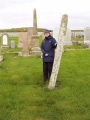
Neolithic and Bronze AgeSite Name: Allée Couverte des Jeannetières Alternative Name: Croix JaunayCountry: France
NOTE: This site is 5.413 km away from the location you searched for.
Département: Bretagne:Côtes-D'Armor (22) Type: Passage Grave
Nearest Town: Lamballe Nearest Village: Plédéliac
Latitude: 48.452360N Longitude: 2.41269W
Condition:
| 5 | Perfect |
| 4 | Almost Perfect |
| 3 | Reasonable but with some damage |
| 2 | Ruined but still recognisable as an ancient site |
| 1 | Pretty much destroyed, possibly visible as crop marks |
| 0 | No data. |
| -1 | Completely destroyed |
| 5 | Superb |
| 4 | Good |
| 3 | Ordinary |
| 2 | Not Good |
| 1 | Awful |
| 0 | No data. |
| 5 | Can be driven to, probably with disabled access |
| 4 | Short walk on a footpath |
| 3 | Requiring a bit more of a walk |
| 2 | A long walk |
| 1 | In the middle of nowhere, a nightmare to find |
| 0 | No data. |
| 5 | co-ordinates taken by GPS or official recorded co-ordinates |
| 4 | co-ordinates scaled from a detailed map |
| 3 | co-ordinates scaled from a bad map |
| 2 | co-ordinates of the nearest village |
| 1 | co-ordinates of the nearest town |
| 0 | no data |
Internal Links:
External Links:
I have visited· I would like to visit
johnstone visited on 14th Jun 2023 - their rating: Cond: 2 Amb: 3 Access: 5
")
La Grande Morinais, Plédéliac, Dinan, Côtes-d'Armor, Brittany
See also: T4T35
Reference:
Loïc Langouët, Les Mégalithes de l’Arrondissement de Dinan, 2004, p.31 & 34
You may be viewing yesterday's version of this page. To see the most up to date information please register for a free account.
")
")
")
")
")
")
")
Do not use the above information on other web sites or publications without permission of the contributor.
Click here to see more info for this site
Nearby sites
Click here to view sites on an interactive map of the areaKey: Red: member's photo, Blue: 3rd party photo, Yellow: other image, Green: no photo - please go there and take one, Grey: site destroyed
Download sites to:
KML (Google Earth)
GPX (GPS waypoints)
CSV (Garmin/Navman)
CSV (Excel)
To unlock full downloads you need to sign up as a Contributory Member. Otherwise downloads are limited to 50 sites.
Turn off the page maps and other distractions
Nearby sites listing. In the following links * = Image available
1.9km ESE 105° Saint-Maleu menhir Standing Stone (Menhir)
2.9km NNW 341° Guihallon Menhir* Standing Stone (Menhir)
3.3km N 4° Allée Couverte des Kerves* Passage Grave
3.4km N 5° Alignement de la Forêt de Saint-Aubin Standing Stones
6.0km NW 326° Chêne Hut allée couverte* Passage Grave
11.7km NNE 11° Allée couverte de La Roche Couverte* Passage Grave
12.0km SSW 196° Saint-Mirel deux menhirs* Standing Stone (Menhir)
12.3km N 351° Ville Bellanger allée couverte* Passage Grave
12.7km W 263° Allée Couverte dite de la Chaise-à-Margot Passage Grave
12.7km W 263° Menhir dit la Chaise-à-Margot* Standing Stone (Menhir)
12.7km W 263° Allée couverte dite de la Chaise-à-Margot* Passage Grave
12.8km W 262° Allée Couverte du Champs des Caves* Passage Grave
13.1km W 263° Allée couverte de la Bourdonnais* Passage Grave
14.2km S 179° Roche aux Fées de la Brousse* Passage Grave
14.4km SSW 204° Allée couverte des Meurtiaux* Passage Grave
16.6km SW 216° Dolmen de Saint-Maudez Burial Chamber or Dolmen
16.6km SSW 209° Pierres de Crokélien* Rock Outcrop
16.8km SW 220° Dolmen du Carouge* Burial Chamber or Dolmen
17.1km WNW 291° Menhir de Carquitté* Standing Stone (Menhir)
17.8km N 354° Allée Couverte de Plurien Passage Grave
18.2km E 79° Clos-Mulon* Ancient Village or Settlement
18.3km E 79° Coriosolis Museum* Museum
18.4km E 80° Musée Archéologique de Corseul* Museum
18.4km E 80° Monterfil* Ancient Village or Settlement
18.7km NNW 329° Ville Pichard Cairn* Chambered Cairn
View more nearby sites and additional images


 We would like to know more about this location. Please feel free to add a brief description and any relevant information in your own language.
 Wir möchten mehr über diese Stätte erfahren. Bitte zögern Sie nicht, eine kurze Beschreibung und relevante Informationen in Deutsch hinzuzufügen.
 Nous aimerions en savoir encore un peu sur les lieux. S'il vous plaît n'hesitez pas à ajouter une courte description et tous les renseignements pertinents dans votre propre langue.
 Quisieramos informarnos un poco más de las lugares. No dude en añadir una breve descripción y otros datos relevantes en su propio idioma.