 with our Megalithic Portal iPhone app")


<< Our Photo Pages >> Saffron Well (Barhaugh) - Holy Well or Sacred Spring in England in Northumberland
Submitted by Anne T on Sunday, 02 September 2018 Page Views: 982
Springs and Holy WellsSite Name: Saffron Well (Barhaugh) Alternative Name: Saffron Well (Kirkhaugh)Country: England County: Northumberland Type: Holy Well or Sacred Spring
Nearest Town: Alston Nearest Village: Kirkhaugh / Slaggyford
Map Ref: NY69285148
Latitude: 54.857161N Longitude: 2.480052W
Condition:
| 5 | Perfect |
| 4 | Almost Perfect |
| 3 | Reasonable but with some damage |
| 2 | Ruined but still recognisable as an ancient site |
| 1 | Pretty much destroyed, possibly visible as crop marks |
| 0 | No data. |
| -1 | Completely destroyed |
| 5 | Superb |
| 4 | Good |
| 3 | Ordinary |
| 2 | Not Good |
| 1 | Awful |
| 0 | No data. |
| 5 | Can be driven to, probably with disabled access |
| 4 | Short walk on a footpath |
| 3 | Requiring a bit more of a walk |
| 2 | A long walk |
| 1 | In the middle of nowhere, a nightmare to find |
| 0 | No data. |
| 5 | co-ordinates taken by GPS or official recorded co-ordinates |
| 4 | co-ordinates scaled from a detailed map |
| 3 | co-ordinates scaled from a bad map |
| 2 | co-ordinates of the nearest village |
| 1 | co-ordinates of the nearest town |
| 0 | no data |
Internal Links:
External Links:
I have visited· I would like to visit
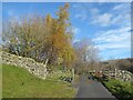
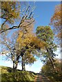
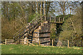
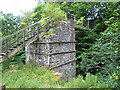
Anne T visited on 31st Aug 2018 - their rating: Cond: 2 Amb: 3 Access: 4 Saffron Well (Barhaugh): After the peace and quiet of Kirkaugh Wells and the Church of the Holy Paraclete, we drove past this even more remote spot. Andrew was brave enough to hop over the stile and descend the very steep, overgrown path down to the river. He reported that a ‘stream just started from nowhere, forming a pool, then running into Barheugh Burn’. Due to the sheer amount of foliage and trees, it was difficult to photograph. Only a very short entry on Pastscape. I've done several internet searches and not been able to find out anything else.
 (PID:185442)")
This well is recorded as Pastscape Monument No. 959024, which simply reads: "Saffron Well - General reference OS 1st Edition, 6", Northumberland 106a, 1865."
Sited close to Barheugh Burn, the well pool can be reached from a stile to its east, over the fence alongside the 68 cycle route; follow a narrow, steep, overgrown track down towards the burn. This pool appears seemingly out of nowhere, water issuing from the hillside, its water then running into the Barhaugh Burn.
Does anyone have any information about this curiously named well, still marked on recent editions of the OS map?
You may be viewing yesterday's version of this page. To see the most up to date information please register for a free account.
Do not use the above information on other web sites or publications without permission of the contributor.
Nearby Images from Geograph Britain and Ireland:
©2020(licence)
©2020(licence)
©2011(licence)
©2020(licence)
©2014(licence)
The above images may not be of the site on this page, they are loaded from Geograph.
Please Submit an Image of this site or go out and take one for us!
Click here to see more info for this site
Nearby sites
Key: Red: member's photo, Blue: 3rd party photo, Yellow: other image, Green: no photo - please go there and take one, Grey: site destroyed
Download sites to:
KML (Google Earth)
GPX (GPS waypoints)
CSV (Garmin/Navman)
CSV (Excel)
To unlock full downloads you need to sign up as a Contributory Member. Otherwise downloads are limited to 50 sites.
Turn off the page maps and other distractions
Nearby sites listing. In the following links * = Image available
994m W 259° Slaggyford Stone Rows* Stone Row / Alignment (NY683513)
1.0km WSW 254° Lintley Observatory* Misc. Earthwork (NY683512)
1.0km W 261° Low Thornhope Farm Rock Art (NY6825951318)
1.1km S 173° Railway Barrow* Artificial Mound (NY694504)
1.8km WNW 286° Amos Hill* Artificial Mound (NY675520)
2.2km SSE 162° Kirkhaugh Cross* Ancient Cross (NY6993849420)
2.2km SSE 159° Kirkhaugh Wells* Holy Well or Sacred Spring (NY7003749441)
2.2km W 265° Robbed Cairn* Cairn (NY671513)
2.5km W 265° Coal Tips Barrow Artificial Mound (NY668513)
2.5km SSE 150° Kirkhaugh Barrow* Round Barrow(s) (NY7054749298)
2.8km WSW 255° Longpot Head Stone Circle* Stone Circle (NY666508)
2.8km S 175° Whitley Castle (Alston)* Hillfort (NY6948948692)
2.9km W 274° Knar Standing Stone* Standing Stone (Menhir) (NY664517)
2.9km SSE 161° Kirkhaugh Stone Circle* Stone Circle (NY702487)
3.0km WSW 248° David's Cobs* Cairn (NY665504)
3.0km W 266° Slaggyford Stones* Standing Stones (NY663513)
3.0km SE 126° Bouker Stones* Standing Stones (NY717497)
3.1km W 269° Knaresdale 1 Rock Art (NY6619751454)
3.1km W 266° Knarsdale N01 Rock Art (NY6615451284)
3.4km WSW 251° Tot's Cupmarked Stone* Standing Stone (Menhir) (NY660504)
3.6km WSW 257° Butter Well Cairns* Cairn (NY658507)
3.6km W 267° Bold Venture* Ancient Mine, Quarry or other Industry (NY657513)
3.7km ENE 70° Wolf Hills Spearhead Find Site Ancient Mine, Quarry or other Industry (NY728527)
3.7km W 281° Hanging Shaw Long Cairn* Cairn (NY656522)
3.9km W 273° Hut Burn Roundhouse* Ancient Village or Settlement (NY654517)
View more nearby sites and additional images


 We would like to know more about this location. Please feel free to add a brief description and any relevant information in your own language.
 Wir möchten mehr über diese Stätte erfahren. Bitte zögern Sie nicht, eine kurze Beschreibung und relevante Informationen in Deutsch hinzuzufügen.
 Nous aimerions en savoir encore un peu sur les lieux. S'il vous plaît n'hesitez pas à ajouter une courte description et tous les renseignements pertinents dans votre propre langue.
 Quisieramos informarnos un poco más de las lugares. No dude en añadir una breve descripción y otros datos relevantes en su propio idioma.