


<< Our Photo Pages >> West Cranmore Round Barrows - Barrow Cemetery in England in Somerset
Submitted by TheCaptain on Tuesday, 10 December 2002 Page Views: 4722
Neolithic and Bronze AgeSite Name: West Cranmore Round Barrows Alternative Name: Old Down FieldCountry: England
NOTE: This site is 1.076 km away from the location you searched for.
County: Somerset Type: Barrow Cemetery
Nearest Town: Shepton Mallet Nearest Village: Cranmore
Map Ref: ST65844274 Landranger Map Number: 183
Latitude: 51.182862N Longitude: 2.490112W
Condition:
| 5 | Perfect |
| 4 | Almost Perfect |
| 3 | Reasonable but with some damage |
| 2 | Ruined but still recognisable as an ancient site |
| 1 | Pretty much destroyed, possibly visible as crop marks |
| 0 | No data. |
| -1 | Completely destroyed |
| 5 | Superb |
| 4 | Good |
| 3 | Ordinary |
| 2 | Not Good |
| 1 | Awful |
| 0 | No data. |
| 5 | Can be driven to, probably with disabled access |
| 4 | Short walk on a footpath |
| 3 | Requiring a bit more of a walk |
| 2 | A long walk |
| 1 | In the middle of nowhere, a nightmare to find |
| 0 | No data. |
| 5 | co-ordinates taken by GPS or official recorded co-ordinates |
| 4 | co-ordinates scaled from a detailed map |
| 3 | co-ordinates scaled from a bad map |
| 2 | co-ordinates of the nearest village |
| 1 | co-ordinates of the nearest town |
| 0 | no data |
Internal Links:
External Links:
I have visited· I would like to visit
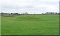
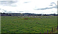
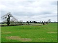
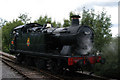
TheCaptain visited on 19th Mar 2023 Seen from the carriage of the East Somerset steam railway near Merryfield Lane halt. Two large round barrows in a field, with fairly distinct ditches around them. There is remains of a third much ploughed out barrow. Looks like badgers are starting to dig away at one of the two large barrows.
")
Two large well defined bell barrows with fairly distinct ditches around them, and remains of a third much ploughed out barrow can be seen to the north of the railway. Others may be destroyed under the railway and in the fields to the south.
Historic England listing here: Two bell barrows and a bowl barrow 370m east of Clover Farm
You may be viewing yesterday's version of this page. To see the most up to date information please register for a free account.
")
")
Do not use the above information on other web sites or publications without permission of the contributor.
Nearby Images from Geograph Britain and Ireland:
©2018(licence)
©2019(licence)
©2018(licence)
©2008(licence)
©2008(licence)
The above images may not be of the site on this page, they are loaded from Geograph.
Please Submit an Image of this site or go out and take one for us!
Click here to see more info for this site
Nearby sites
Key: Red: member's photo, Blue: 3rd party photo, Yellow: other image, Green: no photo - please go there and take one, Grey: site destroyed
Download sites to:
KML (Google Earth)
GPX (GPS waypoints)
CSV (Garmin/Navman)
CSV (Excel)
To unlock full downloads you need to sign up as a Contributory Member. Otherwise downloads are limited to 50 sites.
Turn off the page maps and other distractions
Nearby sites listing. In the following links * = Image available
1.2km WNW 292° St Aldhelm's Well* Holy Well or Sacred Spring (ST647432)
1.3km NW 307° Doulting Quarries barrow* Modern Stone Circle etc (ST64824353)
2.2km SSE 159° Small Down Camp* Hillfort (ST666407)
2.3km SSE 160° Small Down Barrows* Barrow Cemetery (ST666406)
2.5km SSE 149° Evercreech 14-15 Bowl Barrows* Round Barrow(s) (ST67094063)
4.2km NW 325° Beacon Hill (Oakhill) Barrows* Barrow Cemetery (ST63484616)
5.0km N 357° Fairy Cave Cave or Rock Shelter (ST65654775)
6.6km NW 312° Maesbury Castle* Hillfort (ST610472)
6.7km N 4° Stratton on the Fosse Artificial Mound (ST66314938)
6.8km WNW 294° Crapnell Stone Circle (ST596455)
7.5km ENE 67° Nunney Artificial Mound (ST72734564)
7.6km NNW 343° Blackers Hill Promontory Fort* Hillfort (ST6364850045)
7.9km WSW 238° Glastonbury Stone Circle* Modern Stone Circle etc (ST59143858)
8.2km E 98° Witham Friary I Round Barrow(s) (ST74014156)
8.3km SSE 161° Patwell* Holy Well or Sacred Spring (ST6843434863)
8.5km NNW 342° Three Tuns Tumuli* Barrow Cemetery (ST6324250870)
8.7km NNE 13° Giants Grave, Southmead* Long Barrow (ST678512)
8.7km N 353° Fry's Well* Holy Well or Sacred Spring (ST649514)
8.7km NW 316° Whitnell Corner Barrows* Barrow Cemetery (ST5982849096)
8.8km NNE 12° Charmborough Hill Chambered Tomb (ST678513)
9.4km E 94° Witham Friary 2 Round Barrow(s) (ST75264194)
9.5km WNW 287° King's Castle (Wells) Ancient Village or Settlement (ST568456)
10.6km NE 46° Mells, Newbury Firs Artificial Mound (ST73605001)
11.0km WNW 285° Glastonbury Tor milestone at Wells* Modern Stone Circle etc (ST552456)
11.0km WNW 286° St Andrew's Well (Wells)* Holy Well or Sacred Spring (ST5522745824)
View more nearby sites and additional images


 We would like to know more about this location. Please feel free to add a brief description and any relevant information in your own language.
 Wir möchten mehr über diese Stätte erfahren. Bitte zögern Sie nicht, eine kurze Beschreibung und relevante Informationen in Deutsch hinzuzufügen.
 Nous aimerions en savoir encore un peu sur les lieux. S'il vous plaît n'hesitez pas à ajouter une courte description et tous les renseignements pertinents dans votre propre langue.
 Quisieramos informarnos un poco más de las lugares. No dude en añadir una breve descripción y otros datos relevantes en su propio idioma.