


<< Our Photo Pages >> Patwell - Holy Well or Sacred Spring in England in Somerset
Submitted by HOLYWELL on Sunday, 23 March 2008 Page Views: 5139
Springs and Holy WellsSite Name: PatwellCountry: England
NOTE: This site is 2.1 km away from the location you searched for.
County: Somerset Type: Holy Well or Sacred Spring
Nearest Village: Bruton
Map Ref: ST6843434863
Latitude: 51.112184N Longitude: 2.452307W
Condition:
| 5 | Perfect |
| 4 | Almost Perfect |
| 3 | Reasonable but with some damage |
| 2 | Ruined but still recognisable as an ancient site |
| 1 | Pretty much destroyed, possibly visible as crop marks |
| 0 | No data. |
| -1 | Completely destroyed |
| 5 | Superb |
| 4 | Good |
| 3 | Ordinary |
| 2 | Not Good |
| 1 | Awful |
| 0 | No data. |
| 5 | Can be driven to, probably with disabled access |
| 4 | Short walk on a footpath |
| 3 | Requiring a bit more of a walk |
| 2 | A long walk |
| 1 | In the middle of nowhere, a nightmare to find |
| 0 | No data. |
| 5 | co-ordinates taken by GPS or official recorded co-ordinates |
| 4 | co-ordinates scaled from a detailed map |
| 3 | co-ordinates scaled from a bad map |
| 2 | co-ordinates of the nearest village |
| 1 | co-ordinates of the nearest town |
| 0 | no data |
Internal Links:
External Links:
")
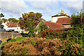
Authorities believe that the name derives from St Patrick's Well. The structure consists of a square well house with a distinctive conical roof made of large slabs and an ancient door. This now covers a pump, which can be inspected by making an appointment with the Parish Council.
You may be viewing yesterday's version of this page. To see the most up to date information please register for a free account.
")
Do not use the above information on other web sites or publications without permission of the contributor.
davidmorgan has found this location on Google Street View:
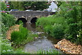
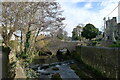
Nearby Images from Geograph Britain and Ireland:
©2023(licence)
©2019(licence)
©2009(licence)
©2022(licence)
©2008(licence)
The above images may not be of the site on this page, they are loaded from Geograph.
Please Submit an Image of this site or go out and take one for us!
Click here to see more info for this site
Nearby sites
Key: Red: member's photo, Blue: 3rd party photo, Yellow: other image, Green: no photo - please go there and take one, Grey: site destroyed
Download sites to:
KML (Google Earth)
GPX (GPS waypoints)
CSV (Garmin/Navman)
CSV (Excel)
To unlock full downloads you need to sign up as a Contributory Member. Otherwise downloads are limited to 50 sites.
Turn off the page maps and other distractions
Nearby sites listing. In the following links * = Image available
5.9km NNW 347° Evercreech 14-15 Bowl Barrows* Round Barrow(s) (ST67094063)
6.0km NNW 342° Small Down Barrows* Barrow Cemetery (ST666406)
6.1km NNW 342° Small Down Camp* Hillfort (ST666407)
6.5km SSE 156° Shad Well* Holy Well or Sacred Spring (ST711289)
6.9km SSE 153° Wincanton and District Museum* Museum (ST7149528680)
7.7km E 86° St. Peter's Pump* Holy Well or Sacred Spring (ST761354)
7.9km E 91° Park Hill Camp* Hillfort (ST76383471)
8.2km SSE 148° Physic Well (Wincanton) Holy Well or Sacred Spring (ST728279)
8.3km NNW 341° West Cranmore Round Barrows* Barrow Cemetery (ST65844274)
8.7km NE 39° Witham Friary I Round Barrow(s) (ST74014156)
9.1km NNW 336° St Aldhelm's Well* Holy Well or Sacred Spring (ST647432)
9.4km NNW 337° Doulting Quarries barrow* Modern Stone Circle etc (ST64824353)
9.7km ESE 112° Egbert's Stone Standing Stone (Menhir) (ST774312)
9.8km ESE 111° Bourton Monolith* Standing Stone (Menhir) (ST7757731221)
9.8km NE 44° Witham Friary 2 Round Barrow(s) (ST75264194)
10.0km WNW 291° Glastonbury Stone Circle* Modern Stone Circle etc (ST59143858)
10.3km SE 136° St Barbara's Well* Holy Well or Sacred Spring
11.0km SSW 209° King Arthur's Well* Holy Well or Sacred Spring (ST630253)
11.0km SSW 210° Queen Anne's Well, Cadbury Castle* Holy Well or Sacred Spring (ST628254)
11.2km SSW 210° South Cadbury Castle* Hillfort (ST62812515)
11.6km NNE 21° Nunney Artificial Mound (ST72734564)
11.7km E 88° Whitesheet Hill* Ancient Village or Settlement (ST80163518)
11.9km E 91° Whitesheet Castle* Hillfort (ST804346)
12.1km NE 44° Conquest Field Round Barrow(s) (ST77004347)
12.3km NNW 336° Beacon Hill (Oakhill) Barrows* Barrow Cemetery (ST63484616)
View more nearby sites and additional images


 We would like to know more about this location. Please feel free to add a brief description and any relevant information in your own language.
 Wir möchten mehr über diese Stätte erfahren. Bitte zögern Sie nicht, eine kurze Beschreibung und relevante Informationen in Deutsch hinzuzufügen.
 Nous aimerions en savoir encore un peu sur les lieux. S'il vous plaît n'hesitez pas à ajouter une courte description et tous les renseignements pertinents dans votre propre langue.
 Quisieramos informarnos un poco más de las lugares. No dude en añadir una breve descripción y otros datos relevantes en su propio idioma.