


<< Our Photo Pages >> Kirkhaugh Cross - Ancient Cross in England in Northumberland
Submitted by Anne T on Saturday, 01 September 2018 Page Views: 1535
Early Medieval (Dark Age)Site Name: Kirkhaugh Cross Alternative Name: Church of the Holy Paraclete (Kirkhaugh)Country: England
NOTE: This site is 0.315 km away from the location you searched for.
County: Northumberland Type: Ancient Cross
Nearest Town: Alston Nearest Village: Kirkhaugh
Map Ref: NY6993849420
Latitude: 54.838690N Longitude: 2.469587W
Condition:
| 5 | Perfect |
| 4 | Almost Perfect |
| 3 | Reasonable but with some damage |
| 2 | Ruined but still recognisable as an ancient site |
| 1 | Pretty much destroyed, possibly visible as crop marks |
| 0 | No data. |
| -1 | Completely destroyed |
| 5 | Superb |
| 4 | Good |
| 3 | Ordinary |
| 2 | Not Good |
| 1 | Awful |
| 0 | No data. |
| 5 | Can be driven to, probably with disabled access |
| 4 | Short walk on a footpath |
| 3 | Requiring a bit more of a walk |
| 2 | A long walk |
| 1 | In the middle of nowhere, a nightmare to find |
| 0 | No data. |
| 5 | co-ordinates taken by GPS or official recorded co-ordinates |
| 4 | co-ordinates scaled from a detailed map |
| 3 | co-ordinates scaled from a bad map |
| 2 | co-ordinates of the nearest village |
| 1 | co-ordinates of the nearest town |
| 0 | no data |
Be the first person to rate this site - see the 'Contribute!' box in the right hand menu.
Internal Links:
External Links:
I have visited· I would like to visit
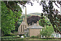
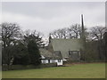
Anne T visited on 31st Aug 2018 - their rating: Cond: 3 Amb: 4 Access: 4 Kirkhaugh Cross, Church of the Holy Paraclete: Having seen one of the wells on the opposite side of the road, we turned our attention to finding the cross. This church is virtually hidden behind the trees, with only a portion of its eastern end and a narrow, tall spire peeping out of the trees at its western end.
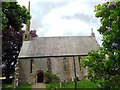
I thought at first this cross was a modern grave marker, as it sits up a modern plinth, but closer examination showed this cross has been used as a gate post at least once in its past.
Behind the cross is a grave stone which has grown into the side of a large horse chestnut tree and been cracked. With the River South Tyne babbling away just behind the eastern churchyard wall, this is a lovely spot.
")
This ancient cross, dated to the second half of the eleventh century, is recorded as Corpus of Anglo Saxon Stone Sculpture, Pastscape Monument No. 13747 and Historic England List ID 1155479.
Classed as pre-Conquest Saxo-Norman, the cross is said to have survived because it had been previously used as a gatepost. It is now mounted on a 19th century stepped stone base and is located some 10m to the south of the door into the church.
The cross stands some 6ft 8ins high, and is cut from a single coarse-grained yellow sandstone block. Pastscape records it was re-sited into the churchyard of the Church of the Holy Paraclete in 1889.
The Corpus describes the cross as being 'complete but weathered', with "two lightly incised crosses at the top and bottom of the shaft", although we could not see these, either during our visit, or on enlargements of photographs later. The Corpus adds that crosses with similar shapes of head can be found on the North Yorkshire Moors, where they were erected as boundary or wayside crosses.
The church sits just to the east of the River South Tyne and is on the site of an older, 13th century, structure.
You may be viewing yesterday's version of this page. To see the most up to date information please register for a free account.
")
")
")
Do not use the above information on other web sites or publications without permission of the contributor.
Nearby Images from Geograph Britain and Ireland:
©2007(licence)
©2013(licence)
©2013(licence)
©2020(licence)
©2013(licence)
The above images may not be of the site on this page, they are loaded from Geograph.
Please Submit an Image of this site or go out and take one for us!
Click here to see more info for this site
Nearby sites
Key: Red: member's photo, Blue: 3rd party photo, Yellow: other image, Green: no photo - please go there and take one, Grey: site destroyed
Download sites to:
KML (Google Earth)
GPX (GPS waypoints)
CSV (Garmin/Navman)
CSV (Excel)
To unlock full downloads you need to sign up as a Contributory Member. Otherwise downloads are limited to 50 sites.
Turn off the page maps and other distractions
Nearby sites listing. In the following links * = Image available
101m ENE 78° Kirkhaugh Wells* Holy Well or Sacred Spring (NY7003749441)
619m E 101° Kirkhaugh Barrow* Round Barrow(s) (NY7054749298)
765m SSE 160° Kirkhaugh Stone Circle* Stone Circle (NY702487)
854m SSW 211° Whitley Castle (Alston)* Hillfort (NY6948948692)
1.1km NNW 331° Railway Barrow* Artificial Mound (NY694504)
1.8km E 81° Bouker Stones* Standing Stones (NY717497)
2.2km NNW 342° Saffron Well (Barhaugh)* Holy Well or Sacred Spring (NY69285148)
2.4km NW 317° Lintley Observatory* Misc. Earthwork (NY683512)
2.5km NW 319° Slaggyford Stone Rows* Stone Row / Alignment (NY683513)
2.5km NW 318° Low Thornhope Farm Rock Art (NY6825951318)
3.4km WNW 303° Robbed Cairn* Cairn (NY671513)
3.5km SSE 155° Raise Henge?* Misc. Earthwork (NY714462)
3.5km NW 316° Amos Hill* Artificial Mound (NY675520)
3.6km WNW 286° David's Cobs* Cairn (NY665504)
3.6km WNW 292° Longpot Head Stone Circle* Stone Circle (NY666508)
3.6km WNW 301° Coal Tips Barrow Artificial Mound (NY668513)
3.7km WSW 242° Grey Nag Cairn* Cairn (NY666477)
3.9km SSE 158° Bridge End Henge Misc. Earthwork (NY714458)
4.0km WNW 284° Tot's Cupmarked Stone* Standing Stone (Menhir) (NY660504)
4.1km WNW 297° Slaggyford Stones* Standing Stones (NY663513)
4.1km W 267° Tot's Four-Poster* Stone Circle (NY658492)
4.2km WNW 302° Knar Standing Stone* Standing Stone (Menhir) (NY664517)
4.2km WNW 296° Knarsdale N01 Rock Art (NY6615451284)
4.2km WNW 298° Knaresdale 1 Rock Art (NY6619751454)
4.3km WNW 287° Butter Well Cairns* Cairn (NY658507)
View more nearby sites and additional images


 We would like to know more about this location. Please feel free to add a brief description and any relevant information in your own language.
 Wir möchten mehr über diese Stätte erfahren. Bitte zögern Sie nicht, eine kurze Beschreibung und relevante Informationen in Deutsch hinzuzufügen.
 Nous aimerions en savoir encore un peu sur les lieux. S'il vous plaît n'hesitez pas à ajouter une courte description et tous les renseignements pertinents dans votre propre langue.
 Quisieramos informarnos un poco más de las lugares. No dude en añadir una breve descripción y otros datos relevantes en su propio idioma.