

<< Our Photo Pages >> St. Helen's Well (Newbiggin-on-Lune) - Holy Well or Sacred Spring in England in Cumbria
Submitted by brigantia on Sunday, 27 April 2008 Page Views: 8674
Springs and Holy WellsSite Name: St. Helen's Well (Newbiggin-on-Lune)Country: England
NOTE: This site is 2.191 km away from the location you searched for.
County: Cumbria Type: Holy Well or Sacred Spring
Nearest Town: Appleby-In-Westmorel Nearest Village: Newbiggin on Lune
Map Ref: NY7079905268
Latitude: 54.441973N Longitude: 2.451759W
Condition:
| 5 | Perfect |
| 4 | Almost Perfect |
| 3 | Reasonable but with some damage |
| 2 | Ruined but still recognisable as an ancient site |
| 1 | Pretty much destroyed, possibly visible as crop marks |
| 0 | No data. |
| -1 | Completely destroyed |
| 5 | Superb |
| 4 | Good |
| 3 | Ordinary |
| 2 | Not Good |
| 1 | Awful |
| 0 | No data. |
| 5 | Can be driven to, probably with disabled access |
| 4 | Short walk on a footpath |
| 3 | Requiring a bit more of a walk |
| 2 | A long walk |
| 1 | In the middle of nowhere, a nightmare to find |
| 0 | No data. |
| 5 | co-ordinates taken by GPS or official recorded co-ordinates |
| 4 | co-ordinates scaled from a detailed map |
| 3 | co-ordinates scaled from a bad map |
| 2 | co-ordinates of the nearest village |
| 1 | co-ordinates of the nearest town |
| 0 | no data |
Be the first person to rate this site - see the 'Contribute!' box in the right hand menu.
Internal Links:
External Links:
I have visited· I would like to visit
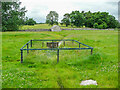
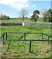
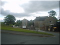
Anne T visited on 11th Sep 2016 - their rating: Cond: 2 Amb: 3 Access: 5 St Helen's Well, Newbeggin-on-Lune, Cumbria: After seeing the Loki Stone at Kirby Steven, we followed the A685 south and west to Newbeggin-on-lune. St Helen’s Well is about 50 metres to the north of the A685 (called Fell Lane at this point). It sits almost at the junction where Chapel Butt Lane splits into two. There is parking for about three cars at this junction.
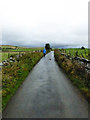
We initially took the left hand fork, walking down to where a footpath sign pointed right over the field containing the well, just before a field gate. Climbing the small stile, walking over the footbridge, we were confused as to where the well was. We understood this well was supposed to be the source of the River Lune, but there are small streams which run to the north/north east which carried a strong flow of water (there must have been a large amount of rain here recently, as the ground was incredibly boggy with large puddles across the paths, as opposed to being dry where we live). Wading through the puddles through the field gate, there was a large boggy area (complete with bull) which appeared to be the lowest point in the area, and the source of the water flow.
Retracing our steps, we asked a local lady who was walking her dog. Despite having visited this area for 34 years, she hadn’t heard of this well. Walking down the right hand lane, the well can be found by walking down the right hand side of Chapel Butt Lane (heading towards Friar Bottom Lane), with the pool becoming visible just after the first bend.
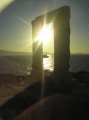
 (PID:117691)")
The source of the River Lune.
You may be viewing yesterday's version of this page. To see the most up to date information please register for a free account.
 (PID:157982)")
 (PID:157983)")
Do not use the above information on other web sites or publications without permission of the contributor.
Nearby Images from Geograph Britain and Ireland:
©2021(licence)
©2019(licence)
©2020(licence)
©2010(licence)
©2017(licence)
The above images may not be of the site on this page, they are loaded from Geograph.
Please Submit an Image of this site or go out and take one for us!
Click here to see more info for this site
Nearby sites
Key: Red: member's photo, Blue: 3rd party photo, Yellow: other image, Green: no photo - please go there and take one, Grey: site destroyed
Download sites to:
KML (Google Earth)
GPX (GPS waypoints)
CSV (Garmin/Navman)
CSV (Excel)
To unlock full downloads you need to sign up as a Contributory Member. Otherwise downloads are limited to 50 sites.
Turn off the page maps and other distractions
Nearby sites listing. In the following links * = Image available
1.5km N 352° Bent's Hill Round Cairn* Round Cairn (NY7060206780)
1.6km NE 44° Crosby Garrett Ancient Village or Settlement (NY719064)
3.0km E 89° Rasett Hill* Round Cairn (NY73780531)
3.1km NW 309° Raiset Pike* Long Barrow (NY68400725)
3.6km NNW 333° Little Asby Scar Round Cairn* Round Cairn (NY6920808493)
4.1km NW 318° Howes Well ring cairn* Ring Cairn (NY6804908373)
5.5km S 181° Adamthwaite Standing Stone* Marker Stone (SD7062899794)
5.6km SSE 155° Fell End Stone Circle* Modern Stone Circle etc (NY73160023)
5.6km NW 311° Little Kinmond Cairn* Cairn (NY66540899)
5.8km NW 320° Muddygill Plain, Great Asby Scar* Cairn (NY6704309747)
6.5km ENE 68° Croglam Castle Ancient Village or Settlement (NY768077)
6.6km NNW 328° Asby Common Ancient Village or Settlement (NY673109)
6.6km WNW 303° Raisbeck Wood* Round Cairn (NY65260896)
6.8km ENE 68° The Loki Stone* Early Christian Sculptured Stone (NY77130774)
6.9km E 97° Round Hill, Birkett Common Round Cairns* Round Cairn (NY7764004444)
7.1km NW 321° Ling Bank South Prehistoric Settlement/Enclosures* Ancient Village or Settlement (NY6639910793)
7.1km NW 305° Castle Folds* Ancient Village or Settlement (NY64990936)
7.3km NW 320° Ling Bank North Settlement/Enclosures* Ancient Village or Settlement (NY6616310906)
7.4km WNW 293° Gamelands* Stone Circle (NY64010816)
7.4km SSE 167° Uldale, Black Moss Marker Stone (SD7237398039)
7.5km S 175° Rawthey Bridge (Fell End)* Stone Circle (SD714978)
7.5km NNW 339° Holborn Hill Ancient Village or Settlement (NY682123)
8.0km S 172° Rawthey Cave Cave or Rock Shelter (SD718973)
8.3km S 178° Rawthey Bridge Stone Circle (SD710970)
8.3km SSW 196° Cautley Spout Cairn Cairn (SD685973)
View more nearby sites and additional images


 We would like to know more about this location. Please feel free to add a brief description and any relevant information in your own language.
 Wir möchten mehr über diese Stätte erfahren. Bitte zögern Sie nicht, eine kurze Beschreibung und relevante Informationen in Deutsch hinzuzufügen.
 Nous aimerions en savoir encore un peu sur les lieux. S'il vous plaît n'hesitez pas à ajouter une courte description et tous les renseignements pertinents dans votre propre langue.
 Quisieramos informarnos un poco más de las lugares. No dude en añadir una breve descripción y otros datos relevantes en su propio idioma.