


<< Our Photo Pages >> Ventner's Hall Cairn (1) - Cairn in England in Northumberland
Submitted by Anne T on Monday, 30 May 2016 Page Views: 1282
Neolithic and Bronze AgeSite Name: Ventner's Hall Cairn (1) Alternative Name: Ventner's Hall Robbed CairnCountry: England
NOTE: This site is 2.479 km away from the location you searched for.
County: Northumberland Type: Cairn
Nearest Town: Haltwhistle Nearest Village: Once Brewed
Map Ref: NY71696841
Latitude: 55.009436N Longitude: 2.444187W
Condition:
| 5 | Perfect |
| 4 | Almost Perfect |
| 3 | Reasonable but with some damage |
| 2 | Ruined but still recognisable as an ancient site |
| 1 | Pretty much destroyed, possibly visible as crop marks |
| 0 | No data. |
| -1 | Completely destroyed |
| 5 | Superb |
| 4 | Good |
| 3 | Ordinary |
| 2 | Not Good |
| 1 | Awful |
| 0 | No data. |
| 5 | Can be driven to, probably with disabled access |
| 4 | Short walk on a footpath |
| 3 | Requiring a bit more of a walk |
| 2 | A long walk |
| 1 | In the middle of nowhere, a nightmare to find |
| 0 | No data. |
| 5 | co-ordinates taken by GPS or official recorded co-ordinates |
| 4 | co-ordinates scaled from a detailed map |
| 3 | co-ordinates scaled from a bad map |
| 2 | co-ordinates of the nearest village |
| 1 | co-ordinates of the nearest town |
| 0 | no data |
Be the first person to rate this site - see the 'Contribute!' box in the right hand menu.
Internal Links:
External Links:
I have visited· I would like to visit
SolarMegalith visited on 18th Jul 2016 - their rating: Cond: 2 Amb: 4 Access: 4
 (PID:149662)")
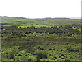
This oval cairn, recorded as HER ID 24608, measures approximately 5 metres by 4 metres, with a depression in the centre, indicating it may have been robbed at some time in the past.
Sitting just to the south of Pont Gallon Burn, it is listed as a prehistoric funerary cairn. We had the honour of walking to this site on a field day with archaeologist Tim Gates, who carried out extensive aerial photography on the Hadrian's Wall landscape from Chesters to Greenhead back in 1999. Tim thinks the cairn was robbed for stone for building. Nearby there is a recently discovered rock art stone with a number of cup marks, the location of which needs to remain under wraps until it is officially recorded.
To the south, near Ventner's Hall, there are clear outlines of two pairs of timber built round houses with associated field systems, first identified from Tim's aerial photographs. To the north west, we believe we may have found another pair of roundhouses, which will be looked at in further detail in a Level 3 survey later this year. A Roman Aqueduct also wends it way across this landscape, clearly visible in some parts, completely hidden in others.
A very interesting place to walk.
You may be viewing yesterday's version of this page. To see the most up to date information please register for a free account.
 (PID:155699)")
Do not use the above information on other web sites or publications without permission of the contributor.
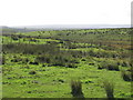
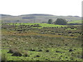
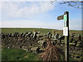
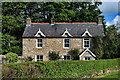
Nearby Images from Geograph Britain and Ireland:
©2010(licence)
©2010(licence)
©2012(licence)
©2011(licence)
©2010(licence)
The above images may not be of the site on this page, they are loaded from Geograph.
Please Submit an Image of this site or go out and take one for us!
Click here to see more info for this site
Nearby sites
Key: Red: member's photo, Blue: 3rd party photo, Yellow: other image, Green: no photo - please go there and take one, Grey: site destroyed
Download sites to:
KML (Google Earth)
GPX (GPS waypoints)
CSV (Garmin/Navman)
CSV (Excel)
To unlock full downloads you need to sign up as a Contributory Member. Otherwise downloads are limited to 50 sites.
Turn off the page maps and other distractions
Nearby sites listing. In the following links * = Image available
290m E 85° Ventner's Hall Cairn (2)* Cairn (NY7198068434)
1.7km S 181° Cawfield Roman Fort Stone Fort or Dun (NY71666667)
2.1km SW 219° Aescia Roman Fort* Stone Fort or Dun (NY7036566800)
2.2km SSE 158° Mare and Foal* Standing Stones (NY72536633)
2.4km SW 218° Aesica Vallum Round Barrow* Round Barrow(s) (NY70196650)
3.8km ENE 63° Chatley Crags Ring Cairn (NY75077012)
3.9km ESE 113° The Sill* Museum (NY7527566896)
3.9km WSW 244° Hadrian's Wall (Turret 44b)* Misc. Earthwork (NY6813866704)
4.0km WSW 244° King Arthur's Well (Walltown Gap)* Holy Well or Sacred Spring (NY68066664)
4.4km E 98° Hadrian's Wall - Milecastle 39* Stone Fort or Dun (NY76066773)
4.5km ESE 119° Smith's Shield Milestone* Marker Stone (NY7561766242)
5.3km E 95° Hadrian's Wall* Misc. Earthwork (NY770679)
5.7km ESE 111° Vindolanda Roman Fort* Stone Fort or Dun (NY7705266352)
5.9km E 79° Greenlee Lough A* Rock Art (NY7751669468)
6.1km ENE 77° Ridley Common Enclosure* Ancient Village or Settlement (NY77676979)
6.2km ENE 77° Ridley Common* Stone Circle (NY77756977)
6.4km SSW 194° Broomhouse (Haltwhistle)* Ancient Village or Settlement (NY70126222)
6.5km ESE 107° Long Stone (Barcombe Hill)* Ancient Cross (NY77896646)
6.5km ENE 76° Greenlee Lough B* Rock Art (NY7806069988)
6.8km ESE 103° Barcombe Hill Settlement* Ancient Village or Settlement (NY78306682)
6.8km E 87° Hadrian's Wall - Milecastle 37* Stone Fort or Dun (NY78506869)
7.3km E 87° Housesteads Roman Fort* Stone Fort or Dun (NY78986880)
7.7km E 90° Housesteads Tumulus* Artificial Mound (NY7938268330)
7.7km E 92° Housesteads Mound* Misc. Earthwork (NY79386815)
7.9km WNW 296° Standingstone Rigg Standing Stone (Cumbria) Standing Stone (Menhir) (NY6458271969)
View more nearby sites and additional images


 We would like to know more about this location. Please feel free to add a brief description and any relevant information in your own language.
 Wir möchten mehr über diese Stätte erfahren. Bitte zögern Sie nicht, eine kurze Beschreibung und relevante Informationen in Deutsch hinzuzufügen.
 Nous aimerions en savoir encore un peu sur les lieux. S'il vous plaît n'hesitez pas à ajouter une courte description et tous les renseignements pertinents dans votre propre langue.
 Quisieramos informarnos un poco más de las lugares. No dude en añadir una breve descripción y otros datos relevantes en su propio idioma.