 with our Megalithic Portal iPhone app")


<< Text Pages >> Cawfield Roman Fort - Stone Fort or Dun in England in Northumberland
Submitted by Antonine on Friday, 08 September 2023 Page Views: 115
Iron Age and Later PrehistorySite Name: Cawfield Roman Fort Alternative Name: Milecastle 42Country: England County: Northumberland Type: Stone Fort or Dun
Nearest Town: Haltwhistle
Map Ref: NY71666667
Latitude: 54.993799N Longitude: 2.444483W
Condition:
| 5 | Perfect |
| 4 | Almost Perfect |
| 3 | Reasonable but with some damage |
| 2 | Ruined but still recognisable as an ancient site |
| 1 | Pretty much destroyed, possibly visible as crop marks |
| 0 | No data. |
| -1 | Completely destroyed |
| 5 | Superb |
| 4 | Good |
| 3 | Ordinary |
| 2 | Not Good |
| 1 | Awful |
| 0 | No data. |
| 5 | Can be driven to, probably with disabled access |
| 4 | Short walk on a footpath |
| 3 | Requiring a bit more of a walk |
| 2 | A long walk |
| 1 | In the middle of nowhere, a nightmare to find |
| 0 | No data. |
| 5 | co-ordinates taken by GPS or official recorded co-ordinates |
| 4 | co-ordinates scaled from a detailed map |
| 3 | co-ordinates scaled from a bad map |
| 2 | co-ordinates of the nearest village |
| 1 | co-ordinates of the nearest town |
| 0 | no data |
Be the first person to rate this site - see the 'Contribute!' box in the right hand menu.
Internal Links:
External Links:
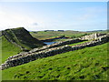
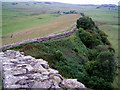
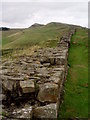
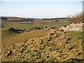
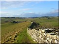
Cawfield Roman Wall and Milecastle 42 can be reached from the car park at Cawfield Quarry. The Milecastles of Hadrian’s Wall can be dated back to 122AD.
A sentry named Lucius fell in love with a Briton girl whose brother was a smuggler. The girl would tease secrets out of Lucius and take them back to her brother. When the brother was caught and implicated Lucius, the sentry realised he had been used by the woman he loved. Lucius killed himself out of shame and doomed himself to eternally stand sentry over the wall he had failed to protect in life. His spectre can be seen hovering 16 feet in the air above Milecastle 42.
A Roman pillar still lies in situ on the Roman Military Way just south of Cawfield Milecastle.
You may be viewing yesterday's version of this page. To see the most up to date information please register for a free account.
Do not use the above information on other web sites or publications without permission of the contributor.
Nearby Images from Geograph Britain and Ireland:
©2009(licence)
©2006(licence)
©2006(licence)
©2019(licence)
©2008(licence)
The above images may not be of the site on this page, they are loaded from Geograph.
Please Submit an Image of this site or go out and take one for us!
Click here to see more info for this site
Nearby sites
Key: Red: member's photo, Blue: 3rd party photo, Yellow: other image, Green: no photo - please go there and take one, Grey: site destroyed
Download sites to:
KML (Google Earth)
GPX (GPS waypoints)
CSV (Garmin/Navman)
CSV (Excel)
To unlock full downloads you need to sign up as a Contributory Member. Otherwise downloads are limited to 50 sites.
Turn off the page maps and other distractions
Nearby sites listing. In the following links * = Image available
932m ESE 111° Mare and Foal* Standing Stones (NY72536633)
1.3km W 275° Aescia Roman Fort* Stone Fort or Dun (NY7036566800)
1.5km W 263° Aesica Vallum Round Barrow* Round Barrow(s) (NY70196650)
1.7km N 1° Ventner's Hall Cairn (1)* Cairn (NY71696841)
1.8km N 10° Ventner's Hall Cairn (2)* Cairn (NY7198068434)
3.5km W 270° Hadrian's Wall (Turret 44b)* Misc. Earthwork (NY6813866704)
3.6km W 269° King Arthur's Well (Walltown Gap)* Holy Well or Sacred Spring (NY68066664)
3.6km E 86° The Sill* Museum (NY7527566896)
4.0km E 96° Smith's Shield Milestone* Marker Stone (NY7561766242)
4.5km ENE 76° Hadrian's Wall - Milecastle 39* Stone Fort or Dun (NY76066773)
4.7km SSW 199° Broomhouse (Haltwhistle)* Ancient Village or Settlement (NY70126222)
4.8km NE 44° Chatley Crags Ring Cairn (NY75077012)
5.4km E 93° Vindolanda Roman Fort* Stone Fort or Dun (NY7705266352)
5.5km ENE 77° Hadrian's Wall* Misc. Earthwork (NY770679)
6.2km E 92° Long Stone (Barcombe Hill)* Ancient Cross (NY77896646)
6.5km ENE 64° Greenlee Lough A* Rock Art (NY7751669468)
6.6km E 88° Barcombe Hill Settlement* Ancient Village or Settlement (NY78306682)
6.8km ENE 62° Ridley Common Enclosure* Ancient Village or Settlement (NY77676979)
6.8km ENE 63° Ridley Common* Stone Circle (NY77756977)
7.1km ENE 73° Hadrian's Wall - Milecastle 37* Stone Fort or Dun (NY78506869)
7.2km ENE 62° Greenlee Lough B* Rock Art (NY7806069988)
7.6km ENE 73° Housesteads Roman Fort* Stone Fort or Dun (NY78986880)
7.7km ESE 111° St Cuthbert's Church, Beltingham* Early Christian Sculptured Stone (NY789639)
7.8km E 79° Housesteads Mound* Misc. Earthwork (NY79386815)
7.9km ENE 77° Housesteads Tumulus* Artificial Mound (NY7938268330)
View more nearby sites and additional images


 We would like to know more about this location. Please feel free to add a brief description and any relevant information in your own language.
 Wir möchten mehr über diese Stätte erfahren. Bitte zögern Sie nicht, eine kurze Beschreibung und relevante Informationen in Deutsch hinzuzufügen.
 Nous aimerions en savoir encore un peu sur les lieux. S'il vous plaît n'hesitez pas à ajouter une courte description et tous les renseignements pertinents dans votre propre langue.
 Quisieramos informarnos un poco más de las lugares. No dude en añadir una breve descripción y otros datos relevantes en su propio idioma.