


<< Our Photo Pages >> Bitton Camp - Misc. Earthwork in England in Gloucestershire
Submitted by 4clydesdale7 on Friday, 07 September 2012 Page Views: 5111
Multi-periodSite Name: Bitton CampCountry: England
NOTE: This site is 1.141 km away from the location you searched for.
County: Gloucestershire Type: Misc. Earthwork
Nearest Town: Bath Nearest Village: Bitton
Map Ref: ST68276968
Latitude: 51.425233N Longitude: 2.457751W
Condition:
| 5 | Perfect |
| 4 | Almost Perfect |
| 3 | Reasonable but with some damage |
| 2 | Ruined but still recognisable as an ancient site |
| 1 | Pretty much destroyed, possibly visible as crop marks |
| 0 | No data. |
| -1 | Completely destroyed |
| 5 | Superb |
| 4 | Good |
| 3 | Ordinary |
| 2 | Not Good |
| 1 | Awful |
| 0 | No data. |
| 5 | Can be driven to, probably with disabled access |
| 4 | Short walk on a footpath |
| 3 | Requiring a bit more of a walk |
| 2 | A long walk |
| 1 | In the middle of nowhere, a nightmare to find |
| 0 | No data. |
| 5 | co-ordinates taken by GPS or official recorded co-ordinates |
| 4 | co-ordinates scaled from a detailed map |
| 3 | co-ordinates scaled from a bad map |
| 2 | co-ordinates of the nearest village |
| 1 | co-ordinates of the nearest town |
| 0 | no data |
Internal Links:
External Links:
I have visited· I would like to visit
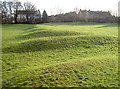
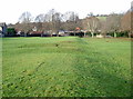
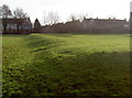
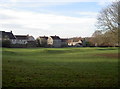
4clydesdale7 visited on 6th Sep 2012 - their rating: Cond: 2 Amb: 4 Access: 5 No evidence yet for this being a Roman Camp but the Local Authority do seem to take a lot of care of the site - nice spot
")
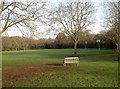
Alas and alack in 1952 a sturdy archaeologist named GC Boon shocked the members of the Bristol and Gloucestershire Archaeological Society when he reported that his excavations had brought nothing to light earlier than artifacts of medieval date from the site - the shape of the camp is correct - the earthworks are somewhat slight for the Romans but the position is good - the SW side has been destroyed by a farmyard and more modern building - still it is a nice pleasant stroll - could it be a 'defended' farmstead? -
Mentioned in the Transactions of BAGAS 1953 Vol 72 pp 45-48 and on the pastscape website South Gloucestershire; Bitton; 200847 - Bitton also has a nice Tollhouse (on the road to Oldland Common) and some attractive roadsigns - The White Hart gives a warm welcome
You may be viewing yesterday's version of this page. To see the most up to date information please register for a free account.
")
")
")
Do not use the above information on other web sites or publications without permission of the contributor.
Nearby Images from Geograph Britain and Ireland:
©2016(licence)
©2016(licence)
©2016(licence)
©2016(licence)
©2016(licence)
The above images may not be of the site on this page, they are loaded from Geograph.
Please Submit an Image of this site or go out and take one for us!
Click here to see more info for this site
Nearby sites
Key: Red: member's photo, Blue: 3rd party photo, Yellow: other image, Green: no photo - please go there and take one, Grey: site destroyed
Download sites to:
KML (Google Earth)
GPX (GPS waypoints)
CSV (Garmin/Navman)
CSV (Excel)
To unlock full downloads you need to sign up as a Contributory Member. Otherwise downloads are limited to 50 sites.
Turn off the page maps and other distractions
Nearby sites listing. In the following links * = Image available
522m WSW 244° Bitton Round Barrow* Round Barrow(s) (ST67806945)
2.7km ESE 107° North Stoke Promontory Fort* Promontory Fort / Cliff Castle (ST70886888)
3.0km ESE 104° Lansdown Tumuli* Barrow Cemetery (ST7114968962)
3.2km NE 46° Wick Burial Chamber (Gloucestershire)* Burial Chamber or Dolmen (ST70587188)
3.3km ESE 103° Lansdown Camp* Misc. Earthwork (ST71446892)
4.1km ENE 64° Freezing Hill Camp* Misc. Earthwork (ST72007148)
4.6km ESE 109° St Alphages Well* Holy Well or Sacred Spring (ST72606815)
5.0km E 81° Cold Ashton Round Barrows* Round Barrow(s) (ST73257045)
5.3km N 4° St Anne’s well (Siston)* Holy Well or Sacred Spring (ST68697494)
5.5km ENE 59° Labourer's Stone* Marker Stone (ST73057251)
5.6km NNE 23° Abson Church* Sculptured Stone (ST70557485)
6.1km S 189° Stantonbury Camp* Hillfort (ST67256366)
6.3km N 1° Shortwood Hill barrow* Round Barrow(s) (ST68457600)
6.7km WNW 295° St Ann's Well (Brislington)* Holy Well or Sacred Spring (ST6217472515)
6.8km N 351° Shortwood Circle* Modern Stone Circle etc (ST67277642)
6.9km ESE 110° St Mary's Well (Charlcombe)* Holy Well or Sacred Spring (ST748673)
8.2km SE 124° Bath Postal Museum* Museum (ST7504564998)
8.4km SE 126° Sacred Spring, Bath* Holy Well or Sacred Spring (ST7505364726)
8.6km ESE 115° Kensington Meadows Holed Megalith Holed Stone
8.7km E 101° Solsbury Hill* Hillfort (ST76876797)
8.8km NW 325° Oldbury Court Camp Ancient Village or Settlement (ST633769)
9.0km WNW 297° Armoury Square Standing Stone (Menhir) (ST60287386)
9.0km WSW 246° Maes Knoll* Hillfort (ST600660)
9.1km NE 39° Dyrham Camp* Hillfort (ST741767)
9.4km N 352° The Beeracres Stone* Modern Stone Circle etc (ST6779)
View more nearby sites and additional images


 We would like to know more about this location. Please feel free to add a brief description and any relevant information in your own language.
 Wir möchten mehr über diese Stätte erfahren. Bitte zögern Sie nicht, eine kurze Beschreibung und relevante Informationen in Deutsch hinzuzufügen.
 Nous aimerions en savoir encore un peu sur les lieux. S'il vous plaît n'hesitez pas à ajouter une courte description et tous les renseignements pertinents dans votre propre langue.
 Quisieramos informarnos un poco más de las lugares. No dude en añadir una breve descripción y otros datos relevantes en su propio idioma.