Featured: How and why the ancients enchanted Great Britain and Brittany

How and why the ancients enchanted Great Britain and Brittany

Random Image


Flagstaff Hill

A Little History of Astro-Archaeology £4.99+p&p

A Little History of Astro-Archaeology £4.99+p&p

Who's Online

There are currently, 256 guests and 3 members online.

You are a guest. To join in, please register for free by clicking here

Sponsors

<< Our Photo Pages >> Devil's Ring and Finger - Holed Stone in England in Staffordshire

Submitted by PaulM on Sunday, 18 December 2022  Page Views: 31400

Neolithic and Bronze AgeSite Name: Devil's Ring and Finger Alternative Name: Devil's Ring & Finger
Country: England
NOTE: This site is 1.833 km away from the location you searched for.

County: Staffordshire Type: Holed Stone
 Nearest Village: Mucklestone
Map Ref: SJ7072737783  Landranger Map Number: 127
Latitude: 52.936639N  Longitude: 2.436989W
Condition:
5Perfect
4Almost Perfect
3Reasonable but with some damage
2Ruined but still recognisable as an ancient site
1Pretty much destroyed, possibly visible as crop marks
0No data.
-1Completely destroyed
3 Ambience:
5Superb
4Good
3Ordinary
2Not Good
1Awful
0No data.
3 Access:
5Can be driven to, probably with disabled access
4Short walk on a footpath
3Requiring a bit more of a walk
2A long walk
1In the middle of nowhere, a nightmare to find
0No data.
2 Accuracy:
5co-ordinates taken by GPS or official recorded co-ordinates
4co-ordinates scaled from a detailed map
3co-ordinates scaled from a bad map
2co-ordinates of the nearest village
1co-ordinates of the nearest town
0no data
4

Internal Links:
External Links:

I have visited· I would like to visit

rldixon BrownEdger cappy would like to visit

Andrewnturner visited on 16th Dec 2022 - their rating: Cond: 3 Amb: 4 Access: 3 Visited in December so undergrowth has died back helping to make access and visibility easier. I am guessing it would be trickier in the summer. The stones are just visible from the footpath, and from there access is down a slight dip and up a bank to the field boundary wall where the stones are placed.

Marko visited on 30th Mar 2018 - their rating: Cond: 2 Amb: 3 Access: 3 Easier to find than I thought. The fact that the stones had been moved from their original location to the field boundary some time in the distant past kind of reflected in the lack of ambience but was still worth the walk to it.. Pleased to say that the barbed wire fences mentioned on other members site logs are now 'down'.

whitemere visited on 2nd Jan 2011 - their rating: Cond: 4 Amb: 4 Access: 3

TimPrevett have visited here

Average ratings for this site from all visit loggers: Condition: 3 Ambience: 3.67 Access: 3

Devil's Ring and Finger
Devil's Ring and Finger submitted by Andrewnturner : December 2022 (Vote or comment on this photo)
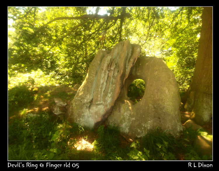
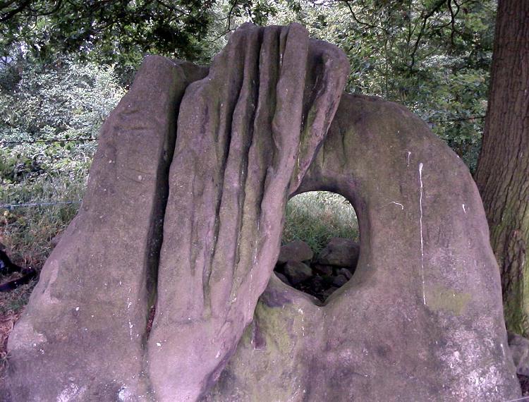
These two stones, one holed, and believed to have come from a chambered tomb, lie close to the village of Mucklestone in Staffordshire. To find them take the footpath marked to Norton in Hales - the stones are located in the field boundary to the right of the line of this path (to the north-east) on private land. The field boundary is orientated north-west/south-east. Follow the boundary for approx 300m and you will find the stones next to a big oak tree.

Both of the stones show sign of wear, the 'finger' is very rilled, while the ring has some old graffiti on it. When we visited there were lots of flies around and electric fences to beware of.

We also found some good candidates for mound material at SJ70703776 and SJ70703776. Please note this site is on private land and permission should be sought before visiting.
You may be viewing yesterday's version of this page. To see the most up to date information please register for a free account.

Devil's Ring and Finger
Devil's Ring and Finger submitted by Paul Morgan : This site is all that remains of a long cairn. The Devil's Ring is a perforated septal stone similar to the one at the Bridestones in Cheshire. The Finger was, perhaps, a portal stone. Neither are in their original position. Located near Mucklestone, Staffordshire and marked on OS map 127. (8 comments - Vote or comment on this photo)

Devil's Ring and Finger
Devil's Ring and Finger submitted by rldixon : Devil's Ring & Finger soft and warm up filter taken 3-6-2011 (Vote or comment on this photo)

Devil's Ring and Finger
Devil's Ring and Finger submitted by rldixon : Devil's ring & finger taken 3-6-2011 at 12-53 pm nice stones a bit difficult to photograph as the sun was behind them (Vote or comment on this photo)

Devil's Ring and Finger
Devil's Ring and Finger submitted by rldixon : Devils ring & finger taken with a soft warm up filter 3-6-2011 (2 comments - Vote or comment on this photo)

Devil's Ring and Finger
Devil's Ring and Finger submitted by Andrewnturner : Taken in December 2022

Devil's Ring and Finger
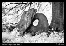
Devil's Ring and Finger submitted by rldixon : Devil's Ring & Finger taken in Infra Red 3-6-2011

Devil's Ring and Finger
Devil's Ring and Finger submitted by rldixon : Devil's Ring & Finger taken in Infra Red 3-6-2011

Devil's Ring and Finger
Devil's Ring and Finger submitted by rldixon : Devils ring & Finger taken from the back into the light 3-6-2011

Devil's Ring and Finger
Devil's Ring and Finger submitted by rldixon : Devils Ring & Finger taken 3-6-2011

Devil's ring and finger
Devil's ring and finger submitted by jackdaw1 : An incumbered peeps in this shot to help to portay a sense of scale. (3 comments)

Devil's Ring and Finger
Devil's Ring and Finger submitted by Humbucker : The Devils Ring & Finger from the copse behind the stones. Lots of stone here which could belong to a mound, if the stones haven't been moved from an original location. (1 comment)

Devil's Ring and Finger
Devil's Ring and Finger submitted by Bladup : The Devil's Ring and Finger, Think how famous it would be if it was in Cornwall.

Devil's Ring and Finger
Devil's Ring and Finger submitted by rldixon : Devil's ring & finger from the other side into the light 3-6-2011

Devil's Ring and Finger
Devil's Ring and Finger submitted by rldixon : Devils ring & Finger taken 3-6-2011

Devil's ring and finger
Devil's ring and finger submitted by jackdaw1 : A slightly abstract study of the devil's ring and finger in Staffordshire. (2 comments)

Devil's Ring and Finger
Devil's Ring and Finger submitted by TimPrevett : A profile of the stones' angle. Finger on right, Ring on left.

Devil's Ring and Finger
Devil's Ring and Finger submitted by Humbucker : The Devils Ring & Finger - view from the edge of the cropline. I took the route along Forge Lane from Norton in Hale, a pleasant walk.

Devil's Ring and Finger
Devil's Ring and Finger submitted by Bladup : The Devil's Ring and Finger, Think how famous it would be if it was in Cornwall.

Devil's Ring and Finger
Devil's Ring and Finger submitted by postman : And lo, or isit 'ol ?

Devil's Ring and Finger
Devil's Ring and Finger submitted by postman : Looking down on the finger

Devil's Ring and Finger
Devil's Ring and Finger submitted by TimPrevett : With my young assistant for scale... yes the stones are big!

Devil's Ring and Finger
Devil's Ring and Finger submitted by Humbucker : The Devils Ring & Finger nestled under the Oak Tree at the edge of the copse.

Devil's Ring and Finger
Devil's Ring and Finger submitted by Bladup : The Devil's Ring and Finger.

Devil's Ring and Finger
Devil's Ring and Finger submitted by postman : That tree is a nice, big, old stone dwarver

These are just the first 25 photos of Devil's Ring and Finger. If you log in with a free user account you will be able to see our entire collection.

Do not use the above information on other web sites or publications without permission of the contributor.
Click here to see more info for this site

Nearby sites

Click here to view sites on an interactive OS map

Key: Red: member's photo, Blue: 3rd party photo, Yellow: other image, Green: no photo - please go there and take one, Grey: site destroyed

Download sites to:
KML (Google Earth)
GPX (GPS waypoints)
CSV (Garmin/Navman)
CSV (Excel)

To unlock full downloads you need to sign up as a Contributory Member. Otherwise downloads are limited to 50 sites.


Turn off the page maps and other distractions

Nearby sites listing. In the following links * = Image available
 815m SSW 196° The Blew Stone Standing Stone (Menhir) (SJ705370)
 882m SW 215° The Ineaz Stone Standing Stone (Menhir) (SJ70223706)
 944m NNW 335° Bradling Stone* Standing Stone (Menhir) (SJ70333864)
 1.8km WSW 240° Betton Standing Stone (Menhir) (SJ69193691)
 5.6km SE 138° Bishop's Wood Hillfort (SJ745336)
 7.5km NW 321° The Bear Stone* Natural Stone / Erratic / Other Natural Feature (SJ66004365)
 7.5km NW 321° St James the Great, Audlem* Round Barrow(s) (SJ66004365)
 8.2km E 80° Berth Hill* Hillfort (SJ788391)
 11.5km SE 128° St. Catherine's Well (Sugnall)* Holy Well or Sacred Spring (SJ798306)
 14.2km E 100° Swynnerton bowl barrow* Barrow Cemetery (SJ8474635109)
 14.8km SE 125° Holy Trinity Church, Eccleshall* Ancient Cross (SJ82752917)
 15.7km NNW 338° Old Biot* Holy Well or Sacred Spring (SJ64965243)
 16.1km ENE 78° St Mary and All Saints (Trentham)* Ancient Cross (SJ8654640940)
 16.3km ENE 59° Market Cross (Newcastle-under-Lyme) Ancient Cross (SJ8485745979)
 16.6km SW 231° Bury Walls* Hillfort (SJ577275)
 16.8km E 93° Saxon's Lowe* Round Barrow(s) (SJ8750136662)
 17.0km NNW 333° Church of St Mary the Virgin (Acton)* Ancient Cross (SJ63175308)
 17.6km E 96° Bury Bank (Staffordshire)* Hillfort (SJ883359)
 17.7km WSW 247° Soulton Long Barrow* Modern Stone Circle etc (SJ5441330922)
 17.8km ESE 121° All Saints (Chebsey)* Ancient Cross (SJ85982856)
 18.6km SE 133° St Anne's Well (nr Lawnhead) Holy Well or Sacred Spring (SJ84262498)
 18.6km ENE 66° Stoke Minster* Ancient Cross (SJ8788745169)
 18.8km SSW 208° Ellerdine Heath* Standing Stone (Menhir) (SJ6191821168)
 19.8km ENE 61° Potteries Museum & Art Gallery* Museum (SJ8815147308)
 20.1km S 187° Wall Camp* Hillfort (SJ681178)
View more nearby sites and additional images

<< Brow Moor - Rock 79

Le Rempart >>

Please add your thoughts on this site

Robin Heath's Alexander Thom: Cracking the Stone Age Code

Robin Heath's Alexander Thom: Cracking the Stone Age Code

Sponsors

Auto-Translation (Google)

Translate from English into:

"Devil's Ring and Finger" | Login/Create an Account | 7 News and Comments
  
Go back to top of page    Comments are owned by the poster. We aren't responsible for their content.
Re: Devil's Ring and Finger by tantrictrick on Thursday, 22 December 2022
(User Info | Send a Message)
Lovely atmospheric and evocative black and white photograph Andrew :)
[ Reply to This ]

Re: Devil's Ring & Finger by Lorret on Monday, 19 December 2022
(User Info | Send a Message)
Does anyone know if these stones had other names ?
It seems ancient places that would have been significant, have been given these disrespectful names
[ Reply to This ]

Re: Devil's Ring and Finger by Marko on Saturday, 31 March 2018
(User Info | Send a Message)
Visited on 3003/18..Pleased to report that the barbed wire fences mentioned elsewhere are now down flat on the grass and look like they have been for some time.So now the site is easily reached in a matter of moments (through the copse) from the footpath.
[ Reply to This ]

Re: Ancient Stones of Oakley Park, walk, 25th January by cooper on Monday, 23 February 2009
(User Info | Send a Message)
Visited the site on wednesday feb 18th 2009 to investigate whether the site of these stones originated elsewhere nearby. I found a christianised stone and several other stones in a small copse nearby. One of the stones had what appeared to be a couple of hand mark positions carved on its face, we also observed two other large stones in the field of the access path away from the block constructed wall and can only assume that they had been moved of the field.

The stones themselves in the copse would normally be hidden by undergrowth, but the recent heavy snowfalls have flattened the area revealing several possible circle alignments, I doubt there integrity, but the stones within the copse are mor than likely something to do with ring and finger. The stones in the wall were almost certainly cut during the Roman occupation of the area
[ Reply to This ]

Re: Devil's Ring and Finger aka Whirl Stones by geoffss on Friday, 13 July 2007
(User Info | Send a Message)
This submission was of great use to me but I have some reservations about the site and ideas relating to it:
1. I have an Oakley Park estate map C17th pre-emparkment (and all that usually entailed for quoits!) and whereas standing stones of interest are detailed there is no stone circle or Devil's Ring/Finger.
2. Is it not true that the two stones are 'over the fence' from Oakley Park and on land called 'The Arbour' (site of a Roman military camp and on Roman Leominche)?
3. There is mention of another quoit further down (and now missing/moved) and by the estate major track - which is dead straight and pointing at Stoke (Chesterton) - ?Leominche? This was called the Blew Stone. I'll post details at missing quoits.

geoffss
[ Reply to This ]

Re: Devil's Ring & Finger by TimPrevett on Thursday, 14 June 2007
(User Info | Send a Message)
Walking along the footpath to Norton In Hales tonight, we were actually forced to take the field past these stones. The footpath was obstructed by a load of brown, horned sheep, who on seeing us actually charged towards us. I don't want to disagree with a bunch of horned sheep!
[ Reply to This ]

Re: Devil's Ring & Finger by Vicky on Tuesday, 27 August 2002
(User Info | Send a Message)
When we visited we were told by the young couple who live in the western gatehouse that the wife had conceived their baby after crawling through the ring!
[ Reply to This ]

Your Name: Anonymous [ Register Now ]
Subject:


Add your comment or contribution to this page. Spam or offensive posts are deleted immediately, don't even bother

<<< What is five plus one as a number? (Please type the answer to this question in the little box on the left)
You can also embed videos and other things. For Youtube please copy and paste the 'embed code'.
For Google Street View please include Street View in the text.
Create a web link like this: <a href="https://www.megalithic.co.uk">This is a link</a>  

Allowed HTML is:
<p> <b> <i> <a> <img> <em> <br> <strong> <blockquote> <tt> <li> <ol> <ul> <object> <param> <embed> <iframe>

We would like to know more about this location. Please feel free to add a brief description and any relevant information in your own language.
Wir möchten mehr über diese Stätte erfahren. Bitte zögern Sie nicht, eine kurze Beschreibung und relevante Informationen in Deutsch hinzuzufügen.
Nous aimerions en savoir encore un peu sur les lieux. S'il vous plaît n'hesitez pas à ajouter une courte description et tous les renseignements pertinents dans votre propre langue.
Quisieramos informarnos un poco más de las lugares. No dude en añadir una breve descripción y otros datos relevantes en su propio idioma.