


<< Our Photo Pages >> Southdown (Dorset) - Barrow Cemetery in England in Dorset
Submitted by JimChampion on Saturday, 28 October 2006 Page Views: 6946
Neolithic and Bronze AgeSite Name: Southdown (Dorset)Country: England
NOTE: This site is 1.717 km away from the location you searched for.
County: Dorset Type: Barrow Cemetery
Nearest Town: Weymouth Nearest Village: Upton
Map Ref: SY749825
Latitude: 50.641643N Longitude: 2.356329W
Condition:
| 5 | Perfect |
| 4 | Almost Perfect |
| 3 | Reasonable but with some damage |
| 2 | Ruined but still recognisable as an ancient site |
| 1 | Pretty much destroyed, possibly visible as crop marks |
| 0 | No data. |
| -1 | Completely destroyed |
| 5 | Superb |
| 4 | Good |
| 3 | Ordinary |
| 2 | Not Good |
| 1 | Awful |
| 0 | No data. |
| 5 | Can be driven to, probably with disabled access |
| 4 | Short walk on a footpath |
| 3 | Requiring a bit more of a walk |
| 2 | A long walk |
| 1 | In the middle of nowhere, a nightmare to find |
| 0 | No data. |
| 5 | co-ordinates taken by GPS or official recorded co-ordinates |
| 4 | co-ordinates scaled from a detailed map |
| 3 | co-ordinates scaled from a bad map |
| 2 | co-ordinates of the nearest village |
| 1 | co-ordinates of the nearest town |
| 0 | no data |
Internal Links:
External Links:
I have visited· I would like to visit
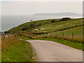
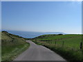
Ogham visited on 9th Aug 2008 - their rating: Cond: 2 Amb: 4 Access: 2 Stunning views of the area around the west Dorset coast.
JimChampion have visited here
 (PID:25533)")
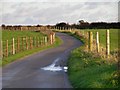
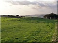
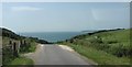
Access The barrows all lie within downland fields, close to the fenced lane from Upton to the South Down National Trust car park which crosses the middle of the cemetery line. The most westerly barrow can be seen from the gate at the top of the toll road down to Ringstead. The other three barrows can be seen from the lane, although the most easterly one has such a low profile that it is very difficult to see.
You may be viewing yesterday's version of this page. To see the most up to date information please register for a free account.
 (PID:25535)")
 (PID:25534)")
 (PID:25532)")
Do not use the above information on other web sites or publications without permission of the contributor.
Nearby Images from Geograph Britain and Ireland:
©2006(licence)
©2006(licence)
©2009(licence)
©2012(licence)
©2019(licence)
The above images may not be of the site on this page, they are loaded from Geograph.
Please Submit an Image of this site or go out and take one for us!
Click here to see more info for this site
Nearby sites
Key: Red: member's photo, Blue: 3rd party photo, Yellow: other image, Green: no photo - please go there and take one, Grey: site destroyed
Download sites to:
KML (Google Earth)
GPX (GPS waypoints)
CSV (Garmin/Navman)
CSV (Excel)
To unlock full downloads you need to sign up as a Contributory Member. Otherwise downloads are limited to 50 sites.
Turn off the page maps and other distractions
Nearby sites listing. In the following links * = Image available
1.1km NNW 340° Poxwell Cairn* Cairn (SY74518357)
3.4km ENE 59° Lord's Barrow* Round Barrow(s) (SY778842)
3.6km ESE 111° Chaldon Down* Barrow Cemetery (SY783812)
4.4km ENE 67° Five Marys* Barrow Cemetery (SY790842)
4.6km ESE 105° Wardstone Barrow* Round Barrow(s) (SY79338133)
4.7km WNW 299° Northdown (Dorset)* Barrow Cemetery (SY708848)
5.3km NNW 327° Little Mayne* Stone Circle (SY720870)
5.5km WNW 301° Broadmayne Bank Barrow* Long Barrow (SY702853)
5.5km WNW 283° Chalbury* Hillfort (SY695838)
6.0km WNW 303° Whitcombe 1* Long Barrow (SY699858)
6.4km WNW 290° Bincombe Barrows* Barrow Cemetery (SY689847)
6.6km NNW 331° Whitcombe* Standing Stone (Menhir) (SY717883)
6.9km NE 56° Blacknoll Hill* Barrow Cemetery (SY80638630)
7.0km ESE 108° Hambury Tout Barrows* Barrow Cemetery (SY81588029)
7.3km WNW 301° Came Down* Barrow Cemetery (SY687863)
7.7km WNW 294° Bincombe Down* Barrow Cemetery (SY679857)
7.7km WNW 297° Winterborne Came 18b (Bincombe) Cairn (SY680860)
8.2km NW 321° Conygar Hill Barrows* Barrow Cemetery (SY697889)
8.4km WNW 293° Ridgeway Hill* Barrow Cemetery (SY672858)
8.4km NNW 332° Mount Pleasant (Dorset)* Henge (SY710900)
8.5km ESE 105° Bindon Hill* Hillfort (SY831803)
8.6km WSW 239° Dripping Well (Weymouth) Holy Well or Sacred Spring (SY6750478079)
8.7km NNW 328° Flagstones Enclosure* Causewayed Enclosure (SY704899)
8.7km NW 313° Herringston Long Barrow* Long Barrow (SY68548844)
8.7km NW 312° Herringston Bowl Barrow* Round Barrow(s) (SY68478842)
View more nearby sites and additional images


 We would like to know more about this location. Please feel free to add a brief description and any relevant information in your own language.
 Wir möchten mehr über diese Stätte erfahren. Bitte zögern Sie nicht, eine kurze Beschreibung und relevante Informationen in Deutsch hinzuzufügen.
 Nous aimerions en savoir encore un peu sur les lieux. S'il vous plaît n'hesitez pas à ajouter une courte description et tous les renseignements pertinents dans votre propre langue.
 Quisieramos informarnos un poco más de las lugares. No dude en añadir una breve descripción y otros datos relevantes en su propio idioma.