

<< Text Pages >> St Mary's Church (Newent) - Ancient Cross in England in Gloucestershire
Submitted by Sunny100 on Monday, 09 August 2010 Page Views: 7574
Early Medieval (Dark Age)Site Name: St Mary's Church (Newent) Alternative Name: The Newent Cross, Edred's StoneCountry: England
NOTE: This site is 1.027 km away from the location you searched for.
County: Gloucestershire Type: Ancient Cross
Nearest Town: Gloucester Nearest Village: Newent
Map Ref: SO724260
Latitude: 51.931821N Longitude: 2.402823W
Condition:
| 5 | Perfect |
| 4 | Almost Perfect |
| 3 | Reasonable but with some damage |
| 2 | Ruined but still recognisable as an ancient site |
| 1 | Pretty much destroyed, possibly visible as crop marks |
| 0 | No data. |
| -1 | Completely destroyed |
| 5 | Superb |
| 4 | Good |
| 3 | Ordinary |
| 2 | Not Good |
| 1 | Awful |
| 0 | No data. |
| 5 | Can be driven to, probably with disabled access |
| 4 | Short walk on a footpath |
| 3 | Requiring a bit more of a walk |
| 2 | A long walk |
| 1 | In the middle of nowhere, a nightmare to find |
| 0 | No data. |
| 5 | co-ordinates taken by GPS or official recorded co-ordinates |
| 4 | co-ordinates scaled from a detailed map |
| 3 | co-ordinates scaled from a bad map |
| 2 | co-ordinates of the nearest village |
| 1 | co-ordinates of the nearest town |
| 0 | no data |
Internal Links:
External Links:
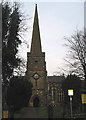
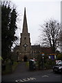
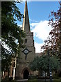
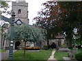
St Mary's Church at Newent, Gloucestershire. In the 13th century CE church of St Mary there is a late Anglo-Saxon cross-shaft and an 11th century stone. The church is famous for its 150 foot high spire. The church site is Anglo-Saxon but there was a Roman settlement here back in the 2nd century CE.
In the porch there is a 9th century cross shaft. The carvings on the front, although rather worn, depict Adam and Eve along with a serpent entwined round what is probably The Tree of Knowledge.
Inside the church a 10th-11th century slab-stone, or a stone tablet. This is similar to grave-slabs that are found in Northumbria; it may have been used as a portable altar-stone. This stone is often called Edred's Stone. This because when the stone was dug up from under the vestry in 1912, two skeletons were found with it, the skull of one of the skeletons resting on the stone had a faint inscription in memory of Edred. This person was possibly a priest.
You may be viewing yesterday's version of this page. To see the most up to date information please register for a free account.
 (PID:99194)")
Do not use the above information on other web sites or publications without permission of the contributor.
Nearby Images from Geograph Britain and Ireland:
©2007(licence)

©2009(licence)
©2010(licence)
©2010(licence)
©2010(licence)
The above images may not be of the site on this page, they are loaded from Geograph.
Please Submit an Image of this site or go out and take one for us!
Click here to see more info for this site
Nearby sites
Key: Red: member's photo, Blue: 3rd party photo, Yellow: other image, Green: no photo - please go there and take one, Grey: site destroyed
Download sites to:
KML (Google Earth)
GPX (GPS waypoints)
CSV (Garmin/Navman)
CSV (Excel)
To unlock full downloads you need to sign up as a Contributory Member. Otherwise downloads are limited to 50 sites.
Turn off the page maps and other distractions
Nearby sites listing. In the following links * = Image available
5.5km SSW 211° May Hill* Misc. Earthwork (SO69542128)
7.9km N 359° Haffield Camp* Hillfort (SO72303390)
8.9km NE 51° Gadbury Bank* Hillfort (SO793316)
11.3km NW 305° Oldbury Camp (Herefordshire)* Hillfort (SO632326)
11.4km SSW 203° Welshbury Cairn* Cairn (SO67831555)
11.4km SSW 204° Welshbury Camp* Hillfort (SO67751555)
11.5km SSW 203° Welshbury Hill Ancient Village or Settlement (SO678154)
11.6km SSW 207° St Anthony's Well (Cinderford)* Holy Well or Sacred Spring (SO67051574)
11.6km WNW 283° Holy Well (Hole in the wall)* Holy Well or Sacred Spring (SO6109028682)
12.1km NNE 17° Midsummer Hill* Hillfort (SO761375)
12.5km NNW 344° Redhill Wood Hillfort* Hillfort (SO690380)
12.6km SE 133° Lady's Well (Gloucestershire)* Holy Well or Sacred Spring (SO815173)
12.6km NNW 345° Wall Hills Camp* Hillfort (SO692382)
12.6km SE 133° Hempsted Camp* Hillfort (SO81551725)
12.7km WSW 253° Chase Wood Camp* Promontory Fort / Cliff Castle (SO602223)
13.1km SSW 203° Littledean Standing Stone* Marker Stone (SO6731713967)
13.8km NNE 15° Walms Well* Holy Well or Sacred Spring (SO76053927)
14.5km NNE 14° Herefordshire Beacon* Hillfort (SO75974003)
14.8km WNW 298° Capler Camp* Hillfort (SO593329)
15.5km SE 132° Well House (Gloucester)* Holy Well or Sacred Spring (SO84001561)
16.0km SE 133° Robins Wood Hill Standing Stones (SO841150)
16.1km S 183° The Awen Stone* Modern Stone Circle etc (SO7149809889)
16.4km SE 131° Red Well (Matson)* Holy Well or Sacred Spring (SO8479615289)
16.4km W 272° Picts Cross Stone (Sellack) Standing Stone (Menhir) (SO560266)
16.5km SSW 201° Dean Heritage Centre* Museum (SO664106)
View more nearby sites and additional images


 We would like to know more about this location. Please feel free to add a brief description and any relevant information in your own language.
 Wir möchten mehr über diese Stätte erfahren. Bitte zögern Sie nicht, eine kurze Beschreibung und relevante Informationen in Deutsch hinzuzufügen.
 Nous aimerions en savoir encore un peu sur les lieux. S'il vous plaît n'hesitez pas à ajouter une courte description et tous les renseignements pertinents dans votre propre langue.
 Quisieramos informarnos un poco más de las lugares. No dude en añadir una breve descripción y otros datos relevantes en su propio idioma.