 with our Megalithic Portal iPhone app")


<< Our Photo Pages >> Viana Menhir - Standing Stone (Menhir) in Spain in Navarra
Submitted by SolarMegalith on Tuesday, 24 June 2008 Page Views: 3235
Neolithic and Bronze AgeSite Name: Viana Menhir Alternative Name: Valverde MenhirCountry: Spain
NOTE: This site is 5.137 km away from the location you searched for.
Region: Navarra Type: Standing Stone (Menhir)
Nearest Town: Viana Nearest Village: Valverde
Latitude: 42.560468N Longitude: 2.383669W
Condition:
| 5 | Perfect |
| 4 | Almost Perfect |
| 3 | Reasonable but with some damage |
| 2 | Ruined but still recognisable as an ancient site |
| 1 | Pretty much destroyed, possibly visible as crop marks |
| 0 | No data. |
| -1 | Completely destroyed |
| 5 | Superb |
| 4 | Good |
| 3 | Ordinary |
| 2 | Not Good |
| 1 | Awful |
| 0 | No data. |
| 5 | Can be driven to, probably with disabled access |
| 4 | Short walk on a footpath |
| 3 | Requiring a bit more of a walk |
| 2 | A long walk |
| 1 | In the middle of nowhere, a nightmare to find |
| 0 | No data. |
| 5 | co-ordinates taken by GPS or official recorded co-ordinates |
| 4 | co-ordinates scaled from a detailed map |
| 3 | co-ordinates scaled from a bad map |
| 2 | co-ordinates of the nearest village |
| 1 | co-ordinates of the nearest town |
| 0 | no data |
Internal Links:
External Links:
I have visited· I would like to visit
SolarMegalith visited on 11th Jun 2006 - their rating: Cond: 3 Amb: 4 Access: 4 Archaeologists whom I met at Longar Arazuri showed me this site.
")
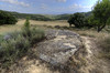
This monument is considered as a standing stone by archaeologists. Now it is fallen, however the condition of the stone itself is good. Probably its from the same period as the nearby Hipogeo De Longar (around 2500 - 2000 BCE).
This standing stone lies just a few meters of the signed road to Hipogeo De Longar, but you need to be carefull - its several meters downhill (be prepared for a steep slope) and you might miss it.
You may be viewing yesterday's version of this page. To see the most up to date information please register for a free account.
Do not use the above information on other web sites or publications without permission of the contributor.
Nearby Images from Flickr

The above images may not be of the site on this page, but were taken nearby. They are loaded from Flickr so please click on them for image credits.
Click here to see more info for this site
Nearby sites
Click here to view sites on an interactive map of the areaKey: Red: member's photo, Blue: 3rd party photo, Yellow: other image, Green: no photo - please go there and take one, Grey: site destroyed
Download sites to:
KML (Google Earth)
GPX (GPS waypoints)
CSV (Garmin/Navman)
CSV (Excel)
To unlock full downloads you need to sign up as a Contributory Member. Otherwise downloads are limited to 50 sites.
Turn off the page maps and other distractions
Nearby sites listing. In the following links * = Image available
2.1km NNW 337° Longar Arazuri Hipogeo* Chambered Tomb
9.4km ESE 110° Sancho Martín Dolmen 1 Burial Chamber or Dolmen
11.2km S 190° Ruinas de Varea Ancient Village or Settlement
12.3km W 276° El Encinal Trikuharria* Burial Chamber or Dolmen
12.7km WNW 287° Los Llanos Trikuharria* Burial Chamber or Dolmen
13.9km W 273° Chabola De La Hechicera* Burial Chamber or Dolmen
15.0km W 274° Alto De La Huesera Trikuharria* Burial Chamber or Dolmen
15.0km SSE 152° Atalayuela Round Barrow(s)
16.6km W 272° La Hoya* Ancient Village or Settlement
17.2km W 271° San Martín Trikuharria* Burial Chamber or Dolmen
17.9km ENE 70° La Pene del Cuarto Castro or Chafurdão
19.6km W 274° El Sotillo Trikuharria* Burial Chamber or Dolmen
20.5km NNE 17° Mojón Largo Menhir Standing Stone (Menhir)
20.5km N 349° Portillo De Guesal Tumulua Round Barrow(s)
20.8km S 188° Unión (Clavijo) Burial Chamber or Dolmen
21.0km N 349° Arboro Eremu Tumularra Barrow Cemetery
21.2km N 349° Obi Eremu Tumularra Barrow Cemetery
22.2km W 276° Layaza Trikuharria* Burial Chamber or Dolmen
22.2km N 3° Bitigarra Eremu Tumularra Barrow Cemetery
22.9km N 5° Santa Teodosia 1 Trikuharria* Burial Chamber or Dolmen
23.0km N 6° Santa Teodosia Eremu Tumularra Barrow Cemetery
23.0km NE 41° Pista Viloria Campo Tumular Round Cairn
23.1km W 268° El Montecillo Trikuharria* Burial Chamber or Dolmen
23.2km N 5° Santa Teodosia 4 Trikuharria Burial Chamber or Dolmen
23.2km NE 41° Sima Campo Tumular Round Cairn
View more nearby sites and additional images


 We would like to know more about this location. Please feel free to add a brief description and any relevant information in your own language.
 Wir möchten mehr über diese Stätte erfahren. Bitte zögern Sie nicht, eine kurze Beschreibung und relevante Informationen in Deutsch hinzuzufügen.
 Nous aimerions en savoir encore un peu sur les lieux. S'il vous plaît n'hesitez pas à ajouter une courte description et tous les renseignements pertinents dans votre propre langue.
 Quisieramos informarnos un poco más de las lugares. No dude en añadir una breve descripción y otros datos relevantes en su propio idioma.