


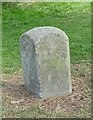
<< Our Photo Pages >> Dursley Merestone - Marker Stone in England in Gloucestershire
Submitted by 4clydesdale7 on Monday, 29 August 2011 Page Views: 5212
Multi-periodSite Name: Dursley MerestoneCountry: England
NOTE: This site is 1.237 km away from the location you searched for.
County: Gloucestershire Type: Marker Stone
Nearest Town: Dursley Nearest Village: Cam
Map Ref: ST748993
Latitude: 51.691881N Longitude: 2.365968W
Condition:
| 5 | Perfect |
| 4 | Almost Perfect |
| 3 | Reasonable but with some damage |
| 2 | Ruined but still recognisable as an ancient site |
| 1 | Pretty much destroyed, possibly visible as crop marks |
| 0 | No data. |
| -1 | Completely destroyed |
| 5 | Superb |
| 4 | Good |
| 3 | Ordinary |
| 2 | Not Good |
| 1 | Awful |
| 0 | No data. |
| 5 | Can be driven to, probably with disabled access |
| 4 | Short walk on a footpath |
| 3 | Requiring a bit more of a walk |
| 2 | A long walk |
| 1 | In the middle of nowhere, a nightmare to find |
| 0 | No data. |
| 5 | co-ordinates taken by GPS or official recorded co-ordinates |
| 4 | co-ordinates scaled from a detailed map |
| 3 | co-ordinates scaled from a bad map |
| 2 | co-ordinates of the nearest village |
| 1 | co-ordinates of the nearest town |
| 0 | no data |
Internal Links:
External Links:
I have visited· I would like to visit
4clydesdale7 visited on 28th Aug 2011 - their rating: Cond: 3 Amb: 3 Access: 5 How can Sullivan not have seen this - perhaps he never thought to check it out - it certainly is not 'old' - nice boundary stone but no more than that
")
It sits close to the sandpits at the point where Dursley and Cam meet at the end of a public footpath up to Stinchcombe Hill and is marked with an 'MS' on the OS Pathfinder map for Dursley - it could be described as a triangular section post - the inscription is just discernible.
The Pastscape website makes no mention of it - it only deserves a mention on this website so that its wrongly perceived ancient 'megalithic' status can be eliminated. Still it is a good example of a boundary stone and incredibly easy to get to.
You may be viewing yesterday's version of this page. To see the most up to date information please register for a free account.
")
")
Do not use the above information on other web sites or publications without permission of the contributor.
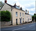
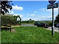
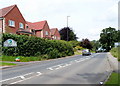
Nearby Images from Geograph Britain and Ireland:
©2013(licence)
©2012(licence)
©2013(licence)
©2019(licence)
©2013(licence)
The above images may not be of the site on this page, they are loaded from Geograph.
Please Submit an Image of this site or go out and take one for us!
Click here to see more info for this site
Nearby sites
Key: Red: member's photo, Blue: 3rd party photo, Yellow: other image, Green: no photo - please go there and take one, Grey: site destroyed
Download sites to:
KML (Google Earth)
GPX (GPS waypoints)
CSV (Garmin/Navman)
CSV (Excel)
To unlock full downloads you need to sign up as a Contributory Member. Otherwise downloads are limited to 50 sites.
Turn off the page maps and other distractions
Nearby sites listing. In the following links * = Image available
1.5km SE 142° The Broadwell* Holy Well or Sacred Spring (ST75749807)
1.7km SW 221° Drakestone Camp* Misc. Earthwork (ST73679801)
2.7km E 85° Cam Long Down Hillfort* Hillfort (ST7753399507)
3.5km SE 133° Folly Wood* Chambered Tomb (ST77339689)
3.7km E 96° Uley Bury* Hillfort (ST78459891)
3.8km SE 128° Rowden Wood* Chambered Tomb (ST77819692)
4.2km E 80° Hetty Pegler's Tump* Passage Grave (SO78960003)
4.5km S 181° Brackenbury Ditches* Promontory Fort / Cliff Castle (ST74709485)
5.0km ENE 66° Nympsfield* Long Barrow (SO79400132)
5.0km ENE 64° Soldier's Grave* Round Barrow(s) (SO79350150)
5.1km SE 126° Wotton Under Edge Cursus Cursus (ST789963)
5.5km ENE 65° Buckholt Wood* Chambered Tomb (SO79860157)
5.9km SE 124° Symonds Hall Farm* Long Barrow (ST79719599)
6.2km WNW 290° Wanswell Holy Well or Sacred Spring (SO68980139)
6.4km SW 219° Damery Camp* Hillfort (ST70749440)
6.6km SSE 156° Blackquarries Hill* Chambered Tomb (ST77529323)
6.8km ENE 67° Woodchester Beaker Barrow* Round Barrow(s) (SO81100198)
7.3km E 89° Lutheredge Earthworks* Misc. Earthwork (ST82089943)
7.4km SW 216° Tortworth Cross* Ancient Cross (ST7043393353)
7.4km ESE 103° Woodleaze Farm* Long Barrow (ST820976)
7.5km ENE 68° Kings Stanley Dyke* Misc. Earthwork (SO818021)
7.8km ENE 71° Bown Hill Bowl Barrow* Round Barrow(s) (SO82240184)
7.9km ESE 102° Woodleaze Bowl Barrow* Round Barrow(s) (ST82489757)
7.9km SE 126° Kingscote Standing Stones* Standing Stones (ST81189467)
7.9km ENE 71° Bown Hill Long Barrow* Long Barrow (SO82290179)
View more nearby sites and additional images


 We would like to know more about this location. Please feel free to add a brief description and any relevant information in your own language.
 Wir möchten mehr über diese Stätte erfahren. Bitte zögern Sie nicht, eine kurze Beschreibung und relevante Informationen in Deutsch hinzuzufügen.
 Nous aimerions en savoir encore un peu sur les lieux. S'il vous plaît n'hesitez pas à ajouter une courte description et tous les renseignements pertinents dans votre propre langue.
 Quisieramos informarnos un poco más de las lugares. No dude en añadir una breve descripción y otros datos relevantes en su propio idioma.