


<< Our Photo Pages >> Duns Mercat Cross - Ancient Cross in Scotland in Scottish Borders
Submitted by Anne T on Sunday, 04 November 2018 Page Views: 1949
Early Medieval (Dark Age)Site Name: Duns Mercat CrossCountry: Scotland
NOTE: This site is 2.282 km away from the location you searched for.
County: Scottish Borders Type: Ancient Cross
Nearest Town: Duns
Map Ref: NT7855253883
Latitude: 55.777791N Longitude: 2.343495W
Condition:
| 5 | Perfect |
| 4 | Almost Perfect |
| 3 | Reasonable but with some damage |
| 2 | Ruined but still recognisable as an ancient site |
| 1 | Pretty much destroyed, possibly visible as crop marks |
| 0 | No data. |
| -1 | Completely destroyed |
| 5 | Superb |
| 4 | Good |
| 3 | Ordinary |
| 2 | Not Good |
| 1 | Awful |
| 0 | No data. |
| 5 | Can be driven to, probably with disabled access |
| 4 | Short walk on a footpath |
| 3 | Requiring a bit more of a walk |
| 2 | A long walk |
| 1 | In the middle of nowhere, a nightmare to find |
| 0 | No data. |
| 5 | co-ordinates taken by GPS or official recorded co-ordinates |
| 4 | co-ordinates scaled from a detailed map |
| 3 | co-ordinates scaled from a bad map |
| 2 | co-ordinates of the nearest village |
| 1 | co-ordinates of the nearest town |
| 0 | no data |
Internal Links:
External Links:
I have visited· I would like to visit
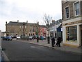
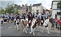
Anne T visited on 27th Oct 2018 - their rating: Cond: 3 Amb: 3 Access: 5 Duns Mercat Cross: Having set off after a snow storm this morning, we stopped off in Duns just after 12 noon for coffee and a scone.
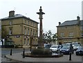
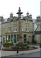
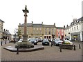
We went to the café we went to when we were here last (some 3-4 years ago), only to find the café open but no-one in, despite many cars in the town. Parking just round the corner from the market square, I realised that there was a market cross which I don’t think I’d photographed before. Whilst the base was ‘modern’ the top appears old.
The café had changed hands, reverting to the original owner, who admitted to being 76 years old and having run a gallery in Harrogate. “We don’t do lunches” we were told. By this time we were cold and hungry so opted for hot scones and tea. A great selection of very reasonably priced antiques to browse round, too, although the only thing I would really have liked to buy wasn't for sale!
The plaque on the cross base reads: “The Mercat Cross of Duns originally stood on the site of the present town hall and was removed when it was rebuilt in 1820. It was re-erected by Andrew Smith Esqr. of Whitchester AD 1897.”
")
The name 'Duns' is derived from either the Gaelic word 'Dun' meaning fort or hill top, which has been Anglicised by adding the 's' on the end or the Anglo Saxon word for a low hill with a flat summit. Originally, Duns was the county town of the county of Berwickshire; this latter became Berwick upon Tweed, which "ended up on the English side of the border in 1482."
Whilst Duns was granted a market in 1489, there was a market cross recorded in the 16th century. This cross was erected in 1792, but then taken down in 1816 to make way for the building of a new town hall, but not re-erected in its current location until 1897.
A small plaque on the base of the cross indicates the head of the cross could be much older.
The town of Duns has both a tourist trail, which can be obtained from the tourist information centre, and also hosts the Jim Clark Room, devoted to the famous Scottish Formula 1 racing driver.
For more information see Canmore ID 58686.
You may be viewing yesterday's version of this page. To see the most up to date information please register for a free account.
")
Do not use the above information on other web sites or publications without permission of the contributor.
Nearby Images from Geograph Britain and Ireland:
©2010(licence)
©2013(licence)
©2013(licence)
©2014(licence)
©2019(licence)
The above images may not be of the site on this page, they are loaded from Geograph.
Please Submit an Image of this site or go out and take one for us!
Click here to see more info for this site
Nearby sites
Key: Red: member's photo, Blue: 3rd party photo, Yellow: other image, Green: no photo - please go there and take one, Grey: site destroyed
Download sites to:
KML (Google Earth)
GPX (GPS waypoints)
CSV (Garmin/Navman)
CSV (Excel)
To unlock full downloads you need to sign up as a Contributory Member. Otherwise downloads are limited to 50 sites.
Turn off the page maps and other distractions
Nearby sites listing. In the following links * = Image available
798m N 356° Duns Law Hillfort* Hillfort (NT78505468)
2.7km N 352° Cumledge Cist* Cist (NT782566)
3.0km NNE 14° Primrose Hill Fort* Hillfort (NT79285682)
3.1km ENE 57° Manderston cist* Cist (NT81125555)
3.2km NE 41° Broomhouse Souterrain* Souterrain (Fogou, Earth House) (NT80675629)
4.2km W 265° Raecleughhead* Hillfort (NT74355351)
4.6km ENE 65° Edrom Sculptured Stone (NT828558)
5.6km N 10° Preston Cleugh Fort* Hillfort (NT79555941)
6.0km NNW 344° Cockburn Law Settlement* Ancient Village or Settlement (NT76915969)
6.2km NNW 341° Cockburn Law Hillfort* Hillfort (NT76565975)
6.6km NNW 348° Edin's Hall* Broch or Nuraghe (NT7724060310)
6.6km N 1° Elba copper mines* Ancient Mine, Quarry or other Industry (NT787605)
7.0km NNE 18° Drakemire hillforts* Hillfort (NT80726051)
7.5km NE 54° The Pech Stane* Standing Stone (Menhir) (NT84685831)
8.3km SW 229° Herriot's Dyke* Misc. Earthwork (NT722485)
9.2km SW 224° Piersknowe Plantation* Cairn (NT72174726)
9.7km NNW 339° Shannabank Hill Hillfort (NT75096292)
11.4km NNE 12° Grantshouse Rock Art* Rock Art (NT8165)
11.9km SSW 192° Crosshall Cross* Ancient Cross (NT76064223)
12.4km SE 126° Monk's Well (Upsettlington)* Holy Well or Sacred Spring (NT8849646471)
12.4km SE 126° St Mary's Well (Upsettlington)* Holy Well or Sacred Spring (NT8865846592)
12.4km SE 125° Nun's Well (Upsettlington)* Holy Well or Sacred Spring (NT8870446652)
12.8km ESE 120° St Cuthbert's Church (Norham)* Ancient Cross (NT8968447411)
13.1km ESE 120° Norham Cross* Ancient Cross (NT8992447329)
13.1km NNE 12° Harelawside Rock Art (NT814667)
View more nearby sites and additional images


 We would like to know more about this location. Please feel free to add a brief description and any relevant information in your own language.
 Wir möchten mehr über diese Stätte erfahren. Bitte zögern Sie nicht, eine kurze Beschreibung und relevante Informationen in Deutsch hinzuzufügen.
 Nous aimerions en savoir encore un peu sur les lieux. S'il vous plaît n'hesitez pas à ajouter une courte description et tous les renseignements pertinents dans votre propre langue.
 Quisieramos informarnos un poco más de las lugares. No dude en añadir una breve descripción y otros datos relevantes en su propio idioma.