


<< Our Photo Pages >> St. Peter's Pump - Holy Well or Sacred Spring in England in Wiltshire
Submitted by kernunos on Sunday, 24 April 2005 Page Views: 10979
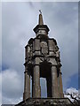
Springs and Holy WellsSite Name: St. Peter's PumpCountry: England County: Wiltshire Type: Holy Well or Sacred Spring
Nearest Town: Mere Nearest Village: Stourton
Map Ref: ST761354
Latitude: 51.117385N Longitude: 2.342834W
Condition:
| 5 | Perfect |
| 4 | Almost Perfect |
| 3 | Reasonable but with some damage |
| 2 | Ruined but still recognisable as an ancient site |
| 1 | Pretty much destroyed, possibly visible as crop marks |
| 0 | No data. |
| -1 | Completely destroyed |
| 5 | Superb |
| 4 | Good |
| 3 | Ordinary |
| 2 | Not Good |
| 1 | Awful |
| 0 | No data. |
| 5 | Can be driven to, probably with disabled access |
| 4 | Short walk on a footpath |
| 3 | Requiring a bit more of a walk |
| 2 | A long walk |
| 1 | In the middle of nowhere, a nightmare to find |
| 0 | No data. |
| 5 | co-ordinates taken by GPS or official recorded co-ordinates |
| 4 | co-ordinates scaled from a detailed map |
| 3 | co-ordinates scaled from a bad map |
| 2 | co-ordinates of the nearest village |
| 1 | co-ordinates of the nearest town |
| 0 | no data |
Internal Links:
External Links:
I have visited· I would like to visit
Jansold visited on 4th Nov 2020 - their rating: Cond: 5 Amb: 4 Access: 4
hevveh have visited here
")
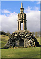
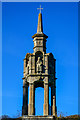
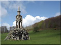
St. Peter's Pump once stood on the corner of Dolphin Street and Peter Street in Bristol.
It was originally erected in the 1470s and stood above St. Edith's Well. The building was removed in the 1760s and placed on a Gothic base in the gardens at Stourhead. Interestingly, the relocated 15th Century structure was placed over an exististing shaft well.
You may be viewing yesterday's version of this page. To see the most up to date information please register for a free account.
")
")
")
")
Do not use the above information on other web sites or publications without permission of the contributor.
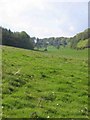
Nearby Images from Geograph Britain and Ireland:
©2005(licence)
©2011(licence)
©2018(licence)
©2012(licence)
©2012(licence)
The above images may not be of the site on this page, they are loaded from Geograph.
Please Submit an Image of this site or go out and take one for us!
Click here to see more info for this site
Nearby sites
Key: Red: member's photo, Blue: 3rd party photo, Yellow: other image, Green: no photo - please go there and take one, Grey: site destroyed
Download sites to:
KML (Google Earth)
GPX (GPS waypoints)
CSV (Garmin/Navman)
CSV (Excel)
To unlock full downloads you need to sign up as a Contributory Member. Otherwise downloads are limited to 50 sites.
Turn off the page maps and other distractions
Nearby sites listing. In the following links * = Image available
744m SSE 158° Park Hill Camp* Hillfort (ST76383471)
4.1km E 93° Whitesheet Hill* Ancient Village or Settlement (ST80163518)
4.4km E 100° Whitesheet Castle* Hillfort (ST804346)
4.4km SSE 163° Egbert's Stone Standing Stone (Menhir) (ST774312)
4.4km SSE 160° Bourton Monolith* Standing Stone (Menhir) (ST7757731221)
5.4km NE 47° Town Well (Maiden Bradley) Holy Well or Sacred Spring (ST8010039028)
6.0km E 85° Rodmead Hill Enclosure Ancient Village or Settlement (ST82123593)
6.2km E 88° Rodmead Barrow Cemetery Barrow Cemetery (ST823356)
6.5km NNW 341° Witham Friary I Round Barrow(s) (ST74014156)
6.6km N 352° Witham Friary 2 Round Barrow(s) (ST75264194)
7.7km W 266° Patwell* Holy Well or Sacred Spring (ST6843434863)
8.0km S 184° St Barbara's Well* Holy Well or Sacred Spring
8.1km N 6° Conquest Field Round Barrow(s) (ST77004347)
8.1km SW 214° Wincanton and District Museum* Museum (ST7149528680)
8.2km SSW 203° Physic Well (Wincanton) Holy Well or Sacred Spring (ST728279)
8.2km SW 217° Shad Well* Holy Well or Sacred Spring (ST711289)
9.9km SSE 152° Gillingham Vicarage (Dorset) Ancient Cross (ST80682656)
10.1km ESE 110° Puckwell* Holy Well or Sacred Spring (ST856319)
10.4km WNW 300° Evercreech 14-15 Bowl Barrows* Round Barrow(s) (ST67094063)
10.8km NNW 342° Nunney Artificial Mound (ST72734564)
10.8km WNW 298° Small Down Barrows* Barrow Cemetery (ST666406)
10.9km WNW 299° Small Down Camp* Hillfort (ST666407)
11.2km E 79° Pertwood Down Long Barrow Long Barrow (ST872374)
11.6km NE 44° Nutball Stone Standing Stone (Menhir) (ST842437)
12.3km NE 40° Cley Hill* Hillfort (ST840448)
View more nearby sites and additional images


 We would like to know more about this location. Please feel free to add a brief description and any relevant information in your own language.
 Wir möchten mehr über diese Stätte erfahren. Bitte zögern Sie nicht, eine kurze Beschreibung und relevante Informationen in Deutsch hinzuzufügen.
 Nous aimerions en savoir encore un peu sur les lieux. S'il vous plaît n'hesitez pas à ajouter une courte description et tous les renseignements pertinents dans votre propre langue.
 Quisieramos informarnos un poco más de las lugares. No dude en añadir una breve descripción y otros datos relevantes en su propio idioma.